This is the inaugural entry for “Buckeye Weather Buzz,” a weekday newsletter devoted to the weather happenings in the Columbus, Ohio and sharing other weather-y tidbits of interest.
Each newsletter will begin with a very brief summary of the next day’s weather forecast, followed by detail of two or three of the main upcoming weather themes in central Ohio. I’ll end it with an insight to our weather or something else happening in the weather world — sometimes something I’ve written, sometimes a link to another source that I feel is worthy of your time.
Tuesday’s tl;dr
🌤️ Mostly sunny and warm, high around 87.
Forecast highlights
🌡️ Midweek warmth
After a loooong stretch of below-average temperatures, we’ll actually be above our normal high on Tuesday. It’ll be the first time since May 16, more than two weeks ago!
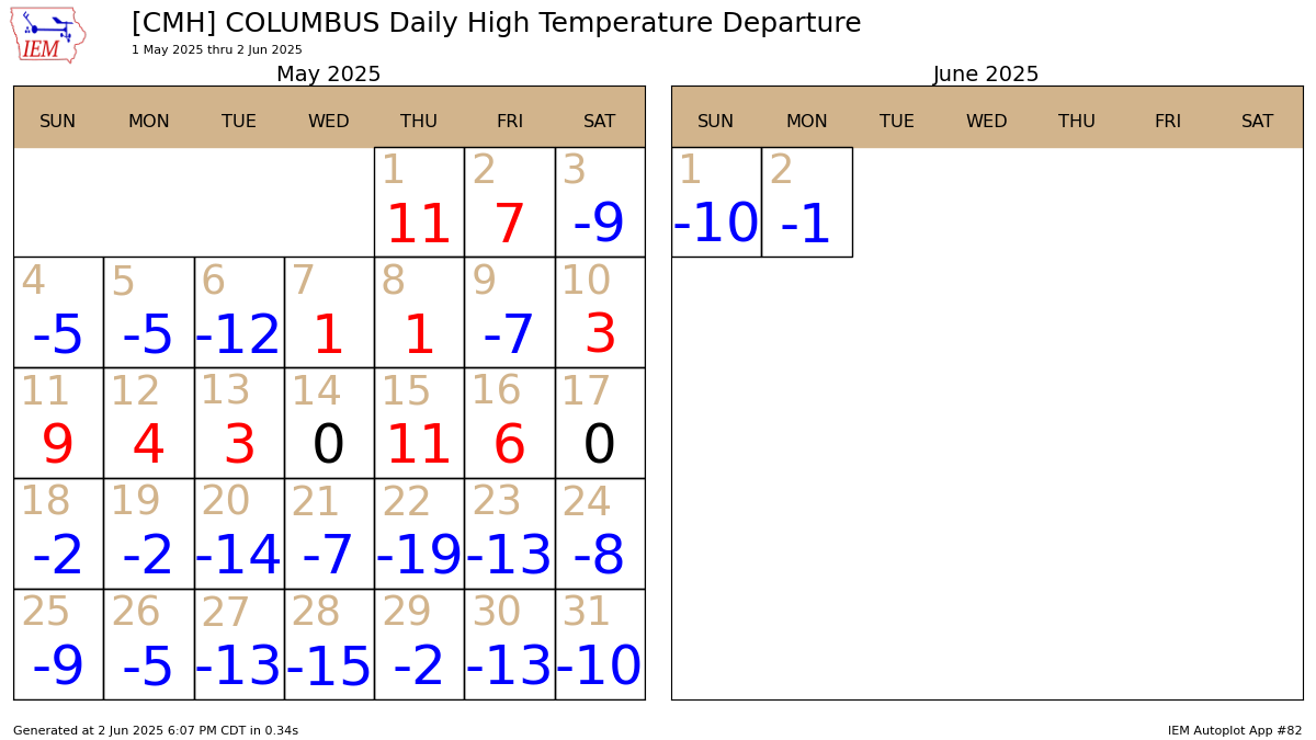
The warmest two days will be Tuesday and Wednesday, with highs in the middle to upper 80s both days. The mugginess also creeps up some on Wednesday. Dew points in the mid-60s will be noticeable, but a breeze out of the southwest should help take the edge off, at least.
☔ A couple of wetter days
Thursday and Friday feature occasional bouts of rain and a few thunderstorms as a weather system gets hung up in the region. I won’t be raining constantly both days, but it looks unsettled enough that I personally am not planning outdoor stuff. Yes, there’ll be dry time, but I have very little confidence on exactly when at this point.
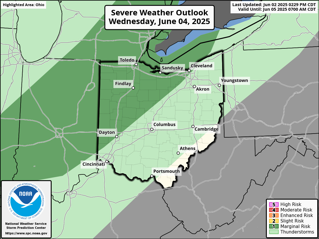
The severe weather threat looks quite low locally. The Storm Prediction Center is highlighting northwestern Ohio with a marginal risk (level 1/5) of severe storms Wednesday afternoon and evening. There’s a low-end chance of a couple of gusty storms. Thursday doesn’t currently hold a noteworthy severe weather potential, either.
🌎 Meteorologists say summer started on June 1. Why?
Most people consider June 20 the first day of summer. Or is it June 21? (Or even June 22, although that’s very rare.)
That’s the trouble with the astronomical seasons: They change. And for record-keeping purposes, like with climate data, you don’t want dates that shift.
So, to keep things simple, climatological summer always begins on June 1. As you might imagine, the other climatological seasons also begin on the first day of their corresponding month: September 1 for fall, December 1 for winter, and March 1 for spring. The only hiccup is that winter gets an extra day every leap year, but that’s small potatoes.
It also turns out that the three months of the year when the average warmest and coldest temperatures happen — at least in temperate mid-latitudes like Ohio — align more closely with climatological summer and winter. The start date of the warmest 91-day period of the year is right about June 8, and has been slowly trending earlier.
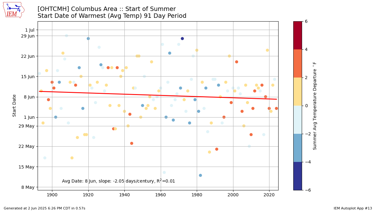
The dots for each year correspond to the start date of the warmest 91 days of that particular year, and how much warmer or cooler than normal the summer was as whole. If an early start to the warmest period always led to a warmer-than-average summer and a late start always led to a cooler-than-average summer, all the dots below the red line would have “warm” colors and the dots above the red line would have “cool” colors. That’s not the case, though.
Thanks for reading this first issue! If you haven’t subscribed, hit that button below:
I’d also appreciate if you share Buckeye Weather Buzz, whether it’s the newsletter (first button) or this post (second button).