The 614cast
Friday’s tl;dr
🌩️ Hit-or-miss showers and storms amongst many dry hours, high in the lower 80s.
Forecast highlights
💧 A little unsettled through early next week
Thanks to a front hanging around the region, we’re not quite done with the rain chance. Friday’s theme will be the same as Thursday’s: Lots of dry time with hit-or-miss activity at most.
Our best opportunity to see peeks of sun is later in the morning through midday. That could help fuel spotty showers and storms popping up again in the afternoon and evening. Again, these will not be widespread. Our house actually missed out on the narrow band of storms that affected most of the metro early Thursday afternoon, so I guess I might have to water again…
There’s another low-end chance that a storm or two might produce gusty winds. We’ll have enough moisture around that any storms could produce a pretty decent downpour, too.

Another disturbance will work across the Great Lakes early next week, so we’ll probably see scattered activity again Sunday and Monday. One of the main computer forecast models favors Monday in particular, so I’ll watch to see whether other guidance converges on that idea.
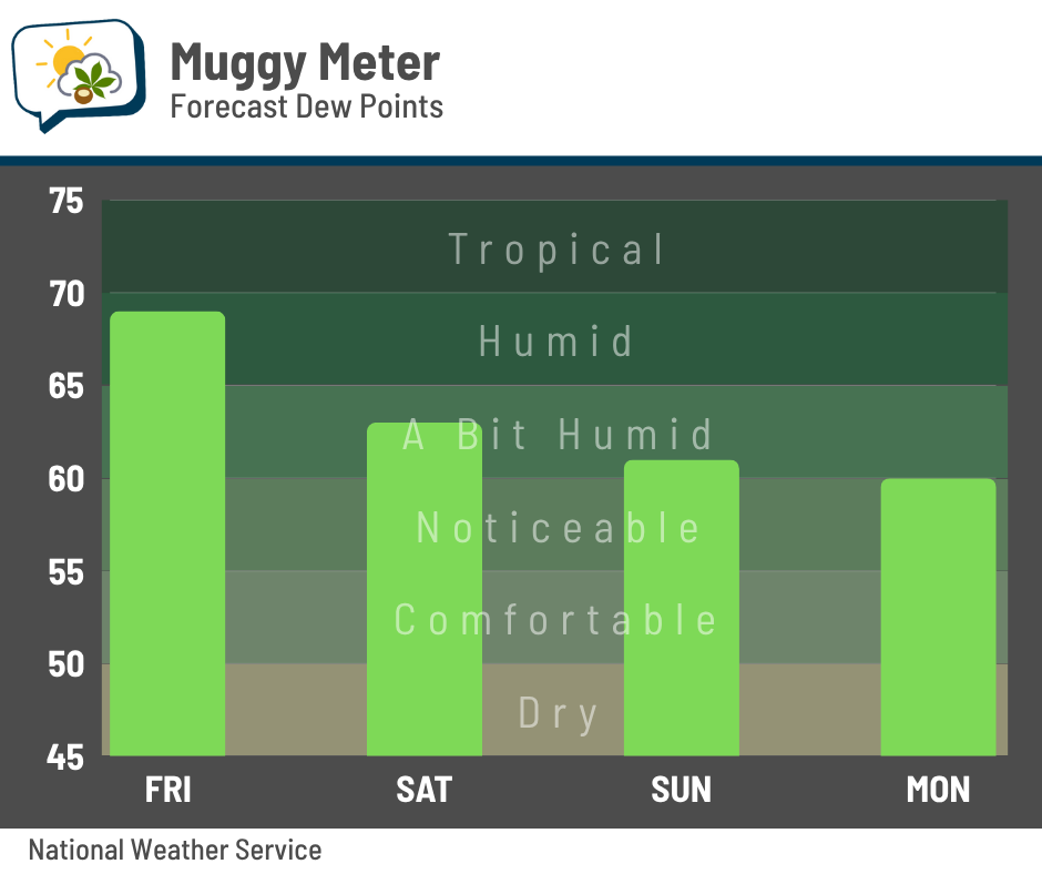
😀 Mugginess trends back down
This weather system pulled in more humid air the past couple of days, and that’ll continue into Friday. Dew points — a measure of moisture in the air — will be deep in the 60s again.
After this system passes, those readings will trend back downward for the weekend into early next week.
📅 Friday’s almanac
Normal low/high: 59 / 80
Record low/high: 43 (1894, 1945, 1993) / 95 (1925)
Sunrise/set: 6:03 a.m. / 8:58 p.m.
🌪️ Night of the Twisters
Tuesday was the 45th anniversary of the Grand Island, Nebraska tornado outbreak — also known as “The Night of the Twisters,” which inspired the book and TV movie of the same name.
You might notice that this tornado outbreak is named for one particular city, rather than a region or date. While this outbreak did affect several states over June 2–3, 1980, the remarkable part was that seven tornadoes hit in or near Grand Island in less than three hours the night of June 3.
Supercell thunderstorms slowly crawled across the city, dropping tornadoes that looped over their own paths and the paths of previous tornadoes. “Anticyclonic” tornadoes, or ones that spin clockwise, are rare; during this event, three of the seven were anticyclonic.
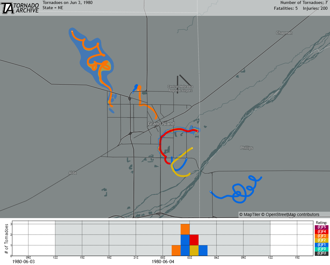
The tornado tracks and damage swaths come from the incredibly detailed survey map produced by renowned tornado researchers Ted Fujita and Roger Wakimoto.
The tornadoes killed five people, and the strongest of the seven was rated F4.
Additional reading and photos:
-
The Real Night of the Twisters (The Grand Island Independent)
-
45th anniversary of the ‘Night of the Twisters’ in Grand Island (Central Nebraska Today)
-
June 3rd, 1980 — A World Class Outbreak (National Weather Service)