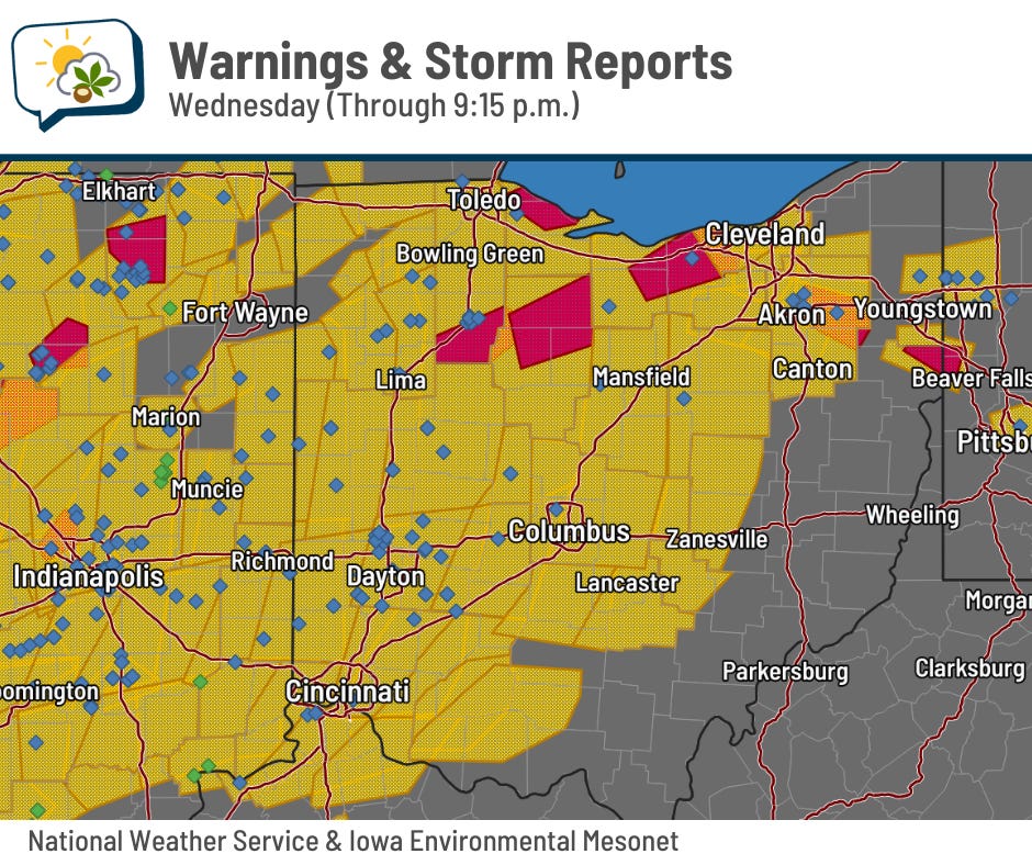
The line of storms last night produced a 56 mph wind gust at the OSU Airport at 7:59 p.m., just short of the official severe wind threshold of 58 mph.
Severe thunderstorm warnings (yellow) stretched across a good share of the state as of 9:15 p.m. last night, and a few places to our north even had tornado warnings (red). Blue diamonds are locations of wind damage or strong wind gusts; green diamonds are hail reports.
The 614cast
Thursday tl;dr
☁️ Isolated lingering showers eventually diminish, clearing late, high near 80.
Forecast highlights
💧 Few more showers possible
A cold front pushes through the area today. That, along with a weak disturbance gliding across the Great Lakes, keeps us in a chance of spotty showers and perhaps a rumble of thunder, mainly through the first part of the afternoon.
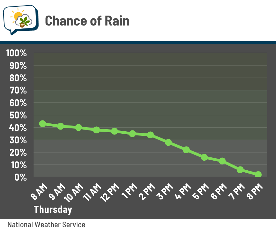
Even when you don’t have rain, quite a few clouds hang around until later in the afternoon and evening. We should see enough clearing to provide a nice sunset to finish off the day.
The mugginess will also drop a bit later today and Friday. Enjoy the break, because…
🌡️ It’s gonna be hotttttt
Yeah, there’s no two ways about it. We’re going to have all the summer feels for a good chunk of next week: hot, humid, and sunny.
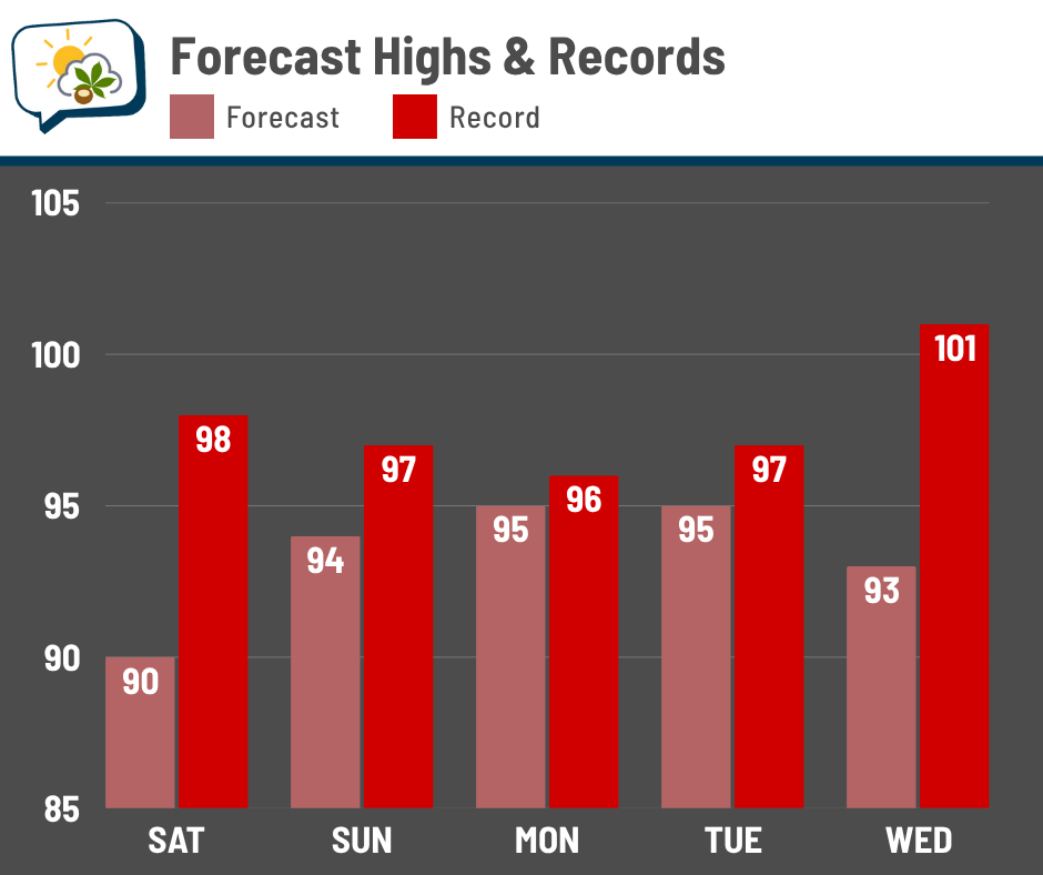
We might hit 90 already on Saturday, but it ought to be a slam dunk Sunday through at least Wednesday. As far as records go, we’ll be pushing them Monday and Tuesday.
Heat indices, or the “feels like” temperature, should peak around 100 degrees Sunday through Tuesday.
One of the problems with this upcoming heat is the very warm morning lows. Because it’ll be humid, they’ll only drop into the lower to middle 70s — hardly enough to provide any real relief or break. When you have several straight days of hot and humid afternoons, plus very warm mornings, the effects add up. Heat-related illness will be something to be very mindful of next week.
📊 Today’s almanac
Normal low/high: 63 / 83
Record low/high: 47 (1959) / 98 (1994)
Sunrise/set: 6:03 a.m. / 9:03 p.m.
🏖️ Summer begins tomorrow
The longest day of the year is tomorrow!
… but that means we start losing daylight on Saturday.

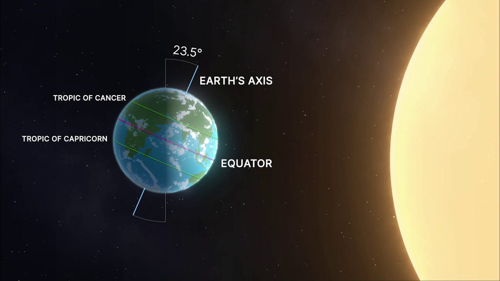
The summer solstice is not actually a full day, though: it’s but a brief moment in time when the sun’s direct rays reach their northernmost point on the Earth, the Tropic of Cancer. This will happen at 10:42 p.m. ET on Friday.
We’ll have 15 hours and 40 seconds of daylight, which is more than five-and-a-half hours longer than the first day of winter.
If you want an entire day of light, head north of the Arctic Circle.
As we continue our journey around the sun, its direct rays will slide back south because the Earth is tilted on its axis. Those direct rays will reach the equator on the first day of fall, then the Tropic of Capricorn at 10:03 a.m. ET on December 21.
🌭 Bonus weather weenie content
-
Climate Station launches on PS5 and PS VR2 (PlayStation)
-
A look at the first artificial solar eclipses created by two European satellites (Associated Press)