Rain since the middle of last week has really added up in spots. Some places south of Columbus have picked up an estimated 5”+, which was enough to cause road closures.
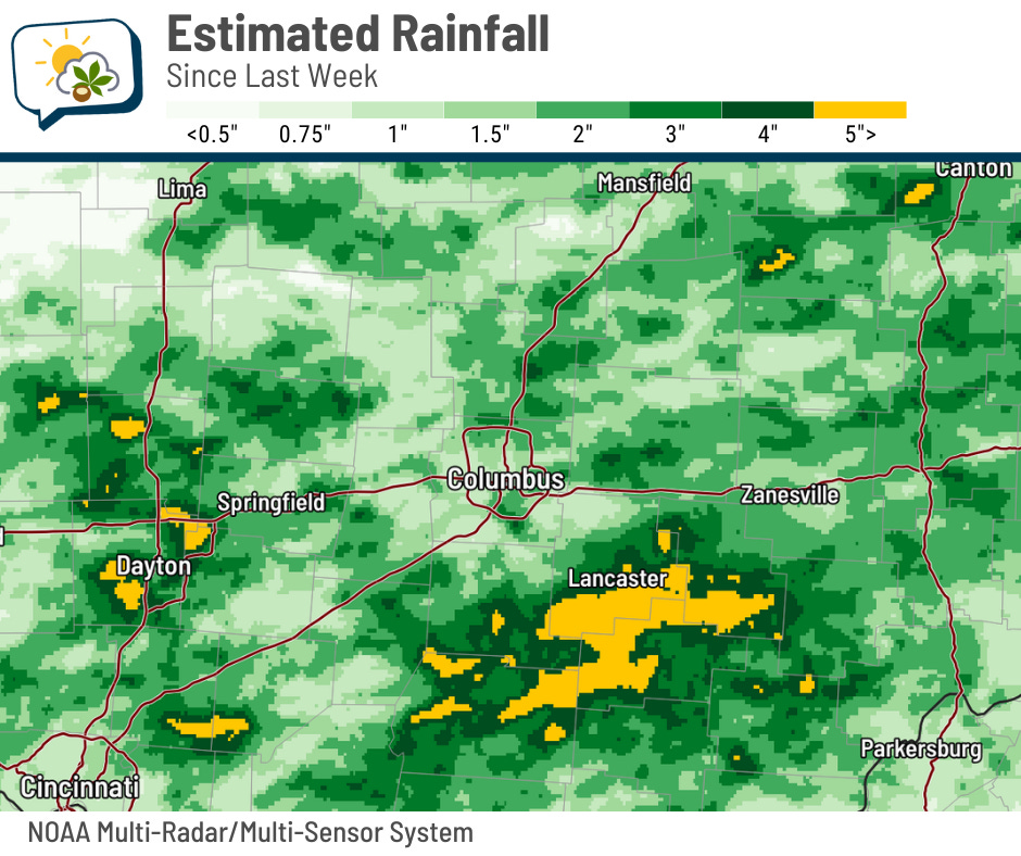
One person died in Hocking Hills when a tree fell and struck them.
The 614cast
Wednesday tl;dr
🕶️ Patchy fog early then mostly sunny, high in the upper 80s.
Forecast highlights
☀️ Feeling like July
Highs reach the upper 80s the next couple of days, then push to 90 and above for the Fourth and the holiday weekend. Below is an animation of how the temperatures about a mile above our heads compare to average; warm colors are, of course, warmer than normal. You can see the warmth gradually spread and increase here as high pressure shifts.
The silver lining is that the humidity won’t be quite as high as it was during last week’s heat. Dew points should remain in the 60s… yes, you’ll feel the mugginess, but it won’t be the tropical stuff.
🚫 Minimal rain chances
I was admittedly surprised at how widespread and persistent the rain was yesterday. There’s not much opportunity for rain surprises in the weather pattern that’s around the next several days. There’s a very slim chance of a shower popping up Thursday through Saturday, but I’d put those odds around 10% or maybe 20%, max.
The next noteworthy opportunity comes early next week as a more organized weather system approaches.
📊 Today’s almanac
Normal low/high: 65 / 85
Record low/high: 48 (1988) / 98 (1911)
Sunrise/set: 6:07 a.m. / 9:04 p.m.
✅ June recap: Warm, wet, and humid
If you felt soggier than usual last month, either from rain or from sweat… or from both… you’re not imagining it. Here’s how last month stacked against other Junes:
-
Average high: 84.3 (2.1 above normal, tied for 27th warmest)
-
Average low: 65.3 (3.7 above normal, 4th warmest)
-
Average overall: 74.8 (2.9 above normal, 8th warmest)
-
Rainfall: 6.19” (1.86” above normal, 19th wettest)
-
Hours with a dew point of at least 70: 198 (2nd most)

-
Hours at or above 90: 32 (just outside the top 10, well above the average of about 14 hours)

-
Hours with a heat index of at least 95: 37 (4th most)
-
Warmest high: 95 (June 24)
-
Coldest low: 44 (June 1 and 2)
-
Number of days with at least 0.10” of rain: 13 (2nd most)