If you follow me on Bluesky, you already saw this tidbit (which is a preview of tomorrow’s “Plus” section):
The 614cast
Wednesday tl;dr
⛈️ Periods of rain/storms, especially in the afternoon and evening. Humid, high in the mid-80s.
Forecast highlights
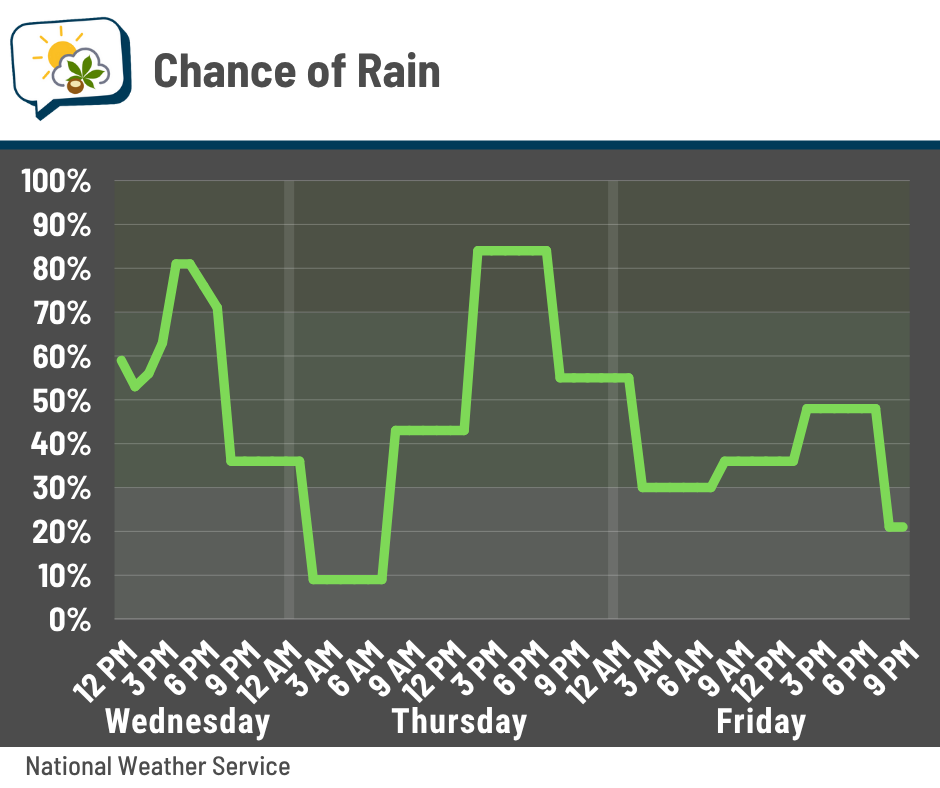
⏰ Tricky rain timing
The front that’s been dangling around the state lifts north today, and a series of disturbances scoot through over the next few days. Each of these impulses may touch off scattered showers and storms… the problem is that they’re small disturbances that can be tricky to time out.
At this point, it looks like we’ll have a decent chance of rain this morning (keep in mind I’m writing this Tuesday afternoon, so I can’t nowcast the situation in the morning when this gets published 🙃), followed by greater odds this afternoon and evening.
Odds go down tonight, with some stuff possibly popping up mostly in the afternoon again tomorrow. Friday’s and Saturday’s chances look more iffy as the next cold front should have pushed far enough south to keep most of the action away from here… but if anything pops, it would favor the afternoon and evening.
💧 More soakers possible
Thunderstorms have had no trouble dumping downpours lately, and that won’t change over the next few days. The atmosphere is laden with moisture, and storms will be able to efficiently tap into that.
While widespread flooding isn’t expected, we could see localized nuisance issues arise for a time as thunderstorms pass by. The Weather Prediction Center’s excessive rainfall outlook, as of Tuesday afternoon, favors parts of eastern Ohio.
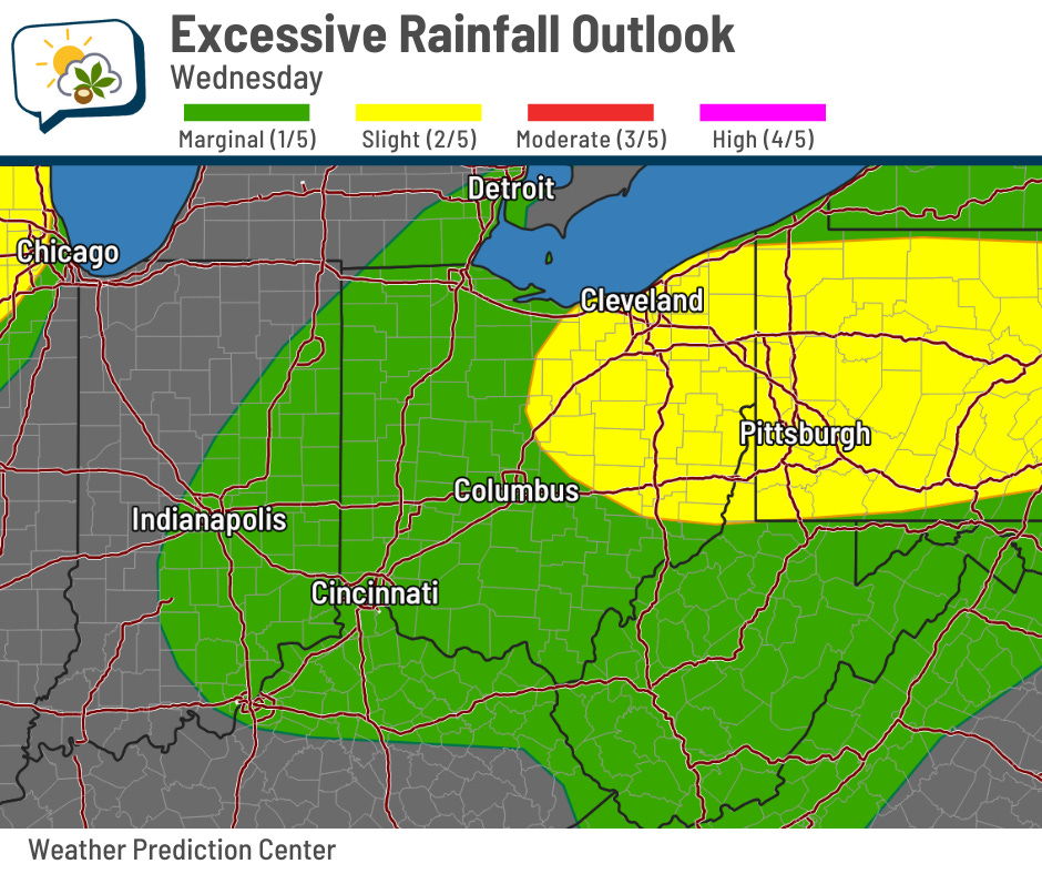
Some neighborhoods here in central Ohio could certainly pick up over an inch on any given day, but exactly where that might happen is just a matter of luck (good or bad, depending on your view).
Through Friday morning, the Weather Prediction Center says we have a:
-
99% chance of getting at least 0.25”
-
94% chance of at least 0.5”
-
53% chance of at least 1”
-
1% chance of at least 2”
📊 Today’s almanac
Normal low/high: 66 / 86
Record low/high: 52 (1967) / 100 (1988)
Sunrise/set: 6:16 a.m. / 8:58 p.m.
🚨 What is a ‘flash flood emergency’?
You’re probably familiar with watches and warnings, but what is this “emergency” that sometimes is mentioned?
The National Weather Service uses flash flood emergencies (and tornado emergencies, for that matter) when they feel a warning situation has an especially significant threat to life and/or property.
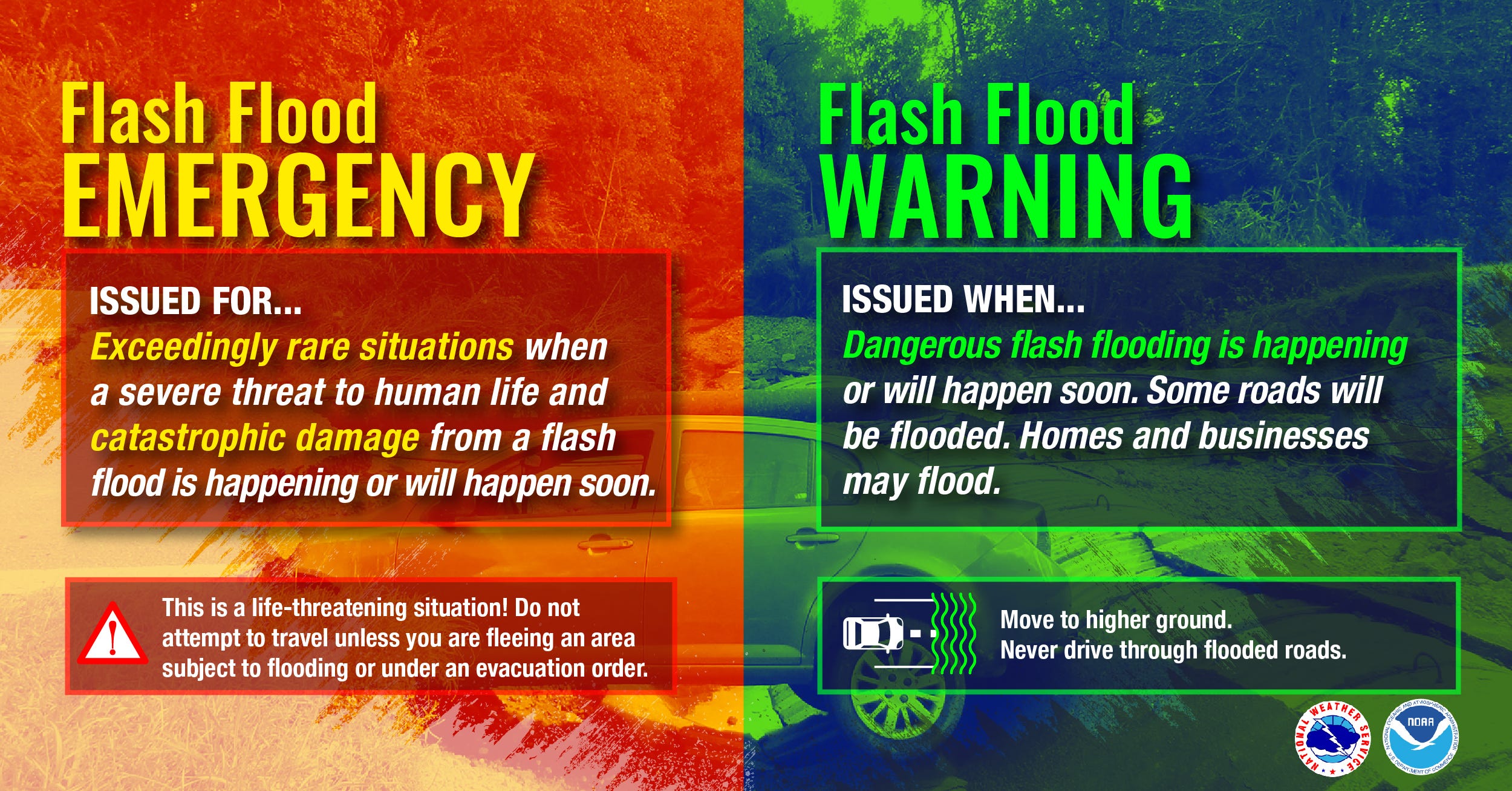
Any flash flooding can become deadly — for example, somebody driving across a flooded road and their car gets carried away — but some situations put many more people in immediate danger.
Flash flood emergencies will trigger smartphones to go off as part of the Wireless Emergency Alert (WEA) system. (Make sure you have weather WEAs turned on!)
Emergencies, by their extreme nature, don’t get issued very often in any particular area. However, several have been issued around the U.S. this summer, and a handful of NWS offices issued at least one just within the past couple of weeks.

The NWS in Wilmington hasn’t issued one in over 3,200 days, or nearly nine years. Northern Ohio has never been under one… yet.
🌭 Bonus weather weenie content
-
We’ve dammed so much water, Earth’s poles have shifted (Scientific American)
-
2 people dead in flash flooding in NJ; storms batter NYC and Tri-State area (ABC7 New York City)