The 614cast
Today’s tl;dr
⛅ Areas of fog early, then partly cloudy. Humid, high in the lower 90s with a heat index near 100.

Forecast highlights
🏁 Almost to the finish line
Whoo boy, the end is in sight… but we have to get through a couple more really humid days to get there.
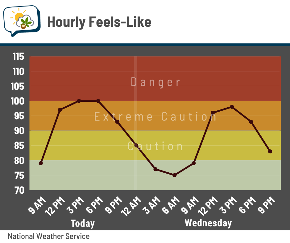
Today should be the warmest day of the week with highs in the lower 90s and heat indices pushing 100 this afternoon. Tomorrow won’t be much better with highs around 90 and a heat index peaking in the upper 90s.
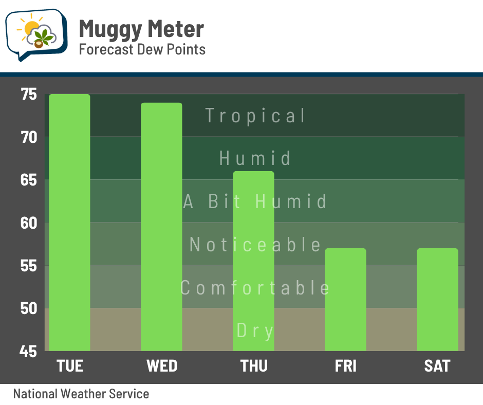
A cold front pushes across the state Wednesday through Wednesday night. Behind it, a change in our weather gradually takes over. After tropical dew points in the 70s the next couple of days, they’ll slowly fall during the day Thursday and eventually settle into much more pleasant 50s Friday and Saturday.
The less humid air, along with more enjoyable highs around 80 or into the lower 80s, will last through early next week.
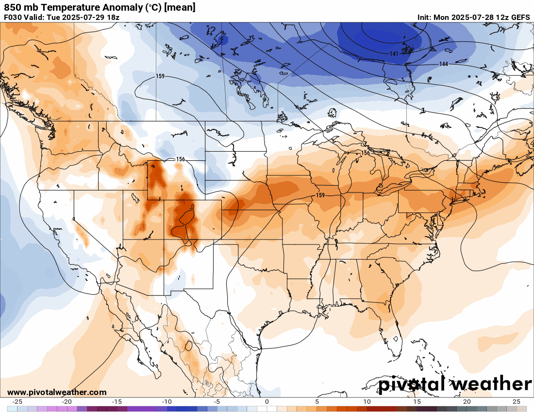
Here’s a look at the temperature anomalies in the upper-level pattern; orange is relatively warm, blue is relatively cool. You’ll see we’re in the warm pattern for now, but Canadian high pressure will send in nicer air for several days. The return of warmer, humid weather trying to edge back in may wait until closer to the second week of August.
🌩️ Storm chances are mostly tomorrow and Thursday
A handful of slow-moving storms popped up in the heat of the day yesterday. There’s a slim chance of one or two developing again today, but it’s very unlikely.
Better odds are here tomorrow afternoon into Thursday in association with the weather system that brings the cooler, drier air.
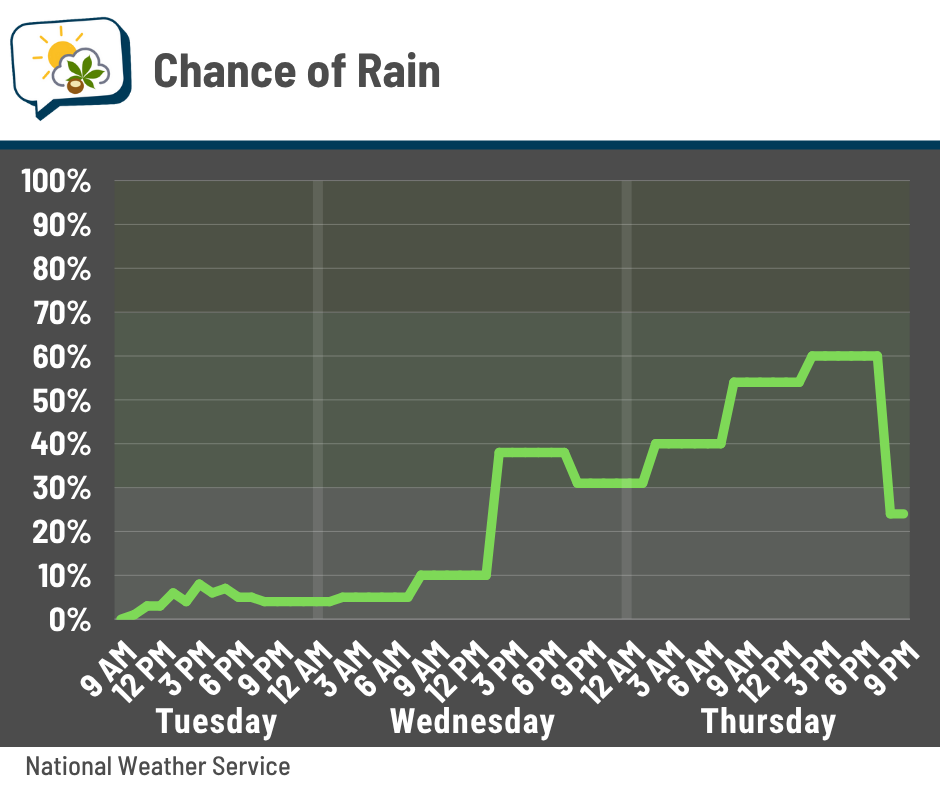
These generally look scattered in nature again. And at the risk of sounding like a broken record, stuff on Wednesday afternoon/evening could produce locally heavy downpours. But that’s kind of a given at this point, isn’t it?
📊 Today’s almanac
Normal low/high: 65 / 85
Record low/high: 51 (1968) / 98 (1940)
Sunrise/set: 6:28 a.m. / 8:48 p.m.
☔ Rainiest summer ever?
Once again, a Reddit thread got my attention. The poster felt like it’s been unusually rainy this summer — not necessarily the amount of rain, but how often it’s rained.
They were absolutely right.

From June 1 through July 27, Columbus officially had:
-
27 days with measurable rain (0.01” or more), which is tied for 10th place. Or, if you care about the number of days rather than ranking by the years, it’s the 5th most.
-
Top spot is 31 days in 1928 and 1892.
But what if you consider days that would have had more than just a light, passing shower? Let’s bump it up to a tenth of an inch.
-
That’s 25 days this summer, the most to-date on record!
-
It beats 1989’s 22 days.
The most days in an entire summer (June 1–August 31) with measurable rain:
-
45, set in 1915 and 1891.
For at least a tenth of an inch:
-
32 days in 2018.
Remarkably, we’re just seven days from tying that and have a whole month to go. We’ll see what happens there.
As far as the amount of rain…
-
We’ve had 10.58” so far.
-
The most through July 27 is 16.67” in 1958.
-
1958 also had the most for an entire summer, logging a total of 22.02”.
🌭 Bonus weather weenie content
-
Uptick in tropical development possible in Atlantic Basin as we head into first part of August (Fox Weather)
-
Researchers quietly planned a test to dim sunlight. They wanted to ‘avoid scaring’ the public (Politico)