The 614cast
Today’s tl;dr
🌦️ Partly to mostly cloudy with a chance of showers. High near 80.

Forecast highlights
🥳 Celebrate! Nicer weather has arrived
Lower temperatures? Check.
Less humid? Check.
As we wrap up July and head into August, much more tolerable weather is here. Most of the next week features highs of 80 to 85, and the next few will be on the low end of that range.
But I think it’s the lower mugginess that’ll raise spirits. Dew points in the mid-60s today will feel pretty reasonable, and they’ll continue dropping tomorrow.
Dew points dip all the way to the lower 50s on Saturday. They rebound somewhat thereafter, but we’re only talking the neighborhood of 60 — still very nice.
Also coming up tomorrow and Saturday, we’ll have sunshine and a nice breeze from the northeast. Top-notch weather compared to what we’ve had most of the summer.
Temperatures and humidity creep back up toward the middle of next week, but it doesn’t look excessive or particularly long-lasting at this point.
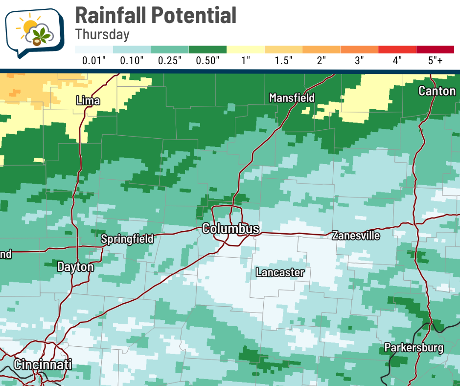
🤔 Uncertainty with today’s rain
While today is less humid, the atmosphere is still laden with moisture. But because the cold front has passed, there’s not much energy to work with to really tap into that moisture and cause big downpours.
Some of our forecast guidance has us practically missing out on rain entirely. While I’m not quite willing to fully bite on that scenario, I do believe that today’s rain will be limited in both coverage and amounts.
If this blend of models is right, only the northern metro would get over a quarter-inch. Indeed, much of what I’ve seen favors totals lower than that for most of us.
📊 Today’s almanac
Normal low/high: 65 / 85
Record low/high: 52 (1895) / 100 (1999)
Sunrise/set: 6:29 a.m. / 8:46 p.m.
🌻 What’s ‘normal’ for August?
Summer’s grip typically starts to loosen in August, allowing the smallest of glimpses of fall. NOAA’s Climate Prediction Center updates their August outlook today, and I’ll feature that in this space tomorrow.
In the meantime, let’s see what August has brought in the past.
Starting off with the normal lows, highs, and rainfall…
-
August 1: 65 / 85
-
August 31: 62 / 82
-
Rainfall: 3.74”
Of course, there’s a lot of variability in our actual daily highs. What’s the average number of days each August with a high falling in a given range?1
-
90s: 5.5 days
-
80s: 19.0
-
70s: 6.2
-
60s: 0.3
What about records?
-
Warmest daily high: 103 in 1918
-
Coolest daily low: 39 in 1965
-
Wettest August: 11.46” in 2003
-
Driest August: 0.33” in 1924
We also lose over an hour of daylight. Here are our sunrise and sunset times, along with the length of day:
-
August 1: 6:30 a.m. / 8:45 p.m. / 14 hours, 15 minutes
-
August 31: 6:59 a.m. / 8:04 p.m. / 13 hours, 5 minutes
🌭 Bonus weather weenie content
-
Animated map of seismic waves from Russia earthquake (WeatherMatrix/Bluesky)
-
NOAA teams up with Zignal Labs to advance storm weather reporting with AI-powered intelligence (NOAA Research)
-
NOAA will maintain vital satellite data used for hurricane forecasting (Axios)
I’m using the 1991–2020 climate period, rather than the entire period of record going back to the 1800s.