🌀 Hurricane Erin continues churning northward off the East Coast. While it won’t directly hit the U.S., it’s brushing the Outer Banks with stiff winds and sending waves and dangerous rip currents along much of the East Coast. Here are the latest updates from the National Hurricane Center.
The 614cast
Today’s tl;dr
🌥️ Mostly cloudy for most of the day, high near 80.
Forecast highlights
🎢 Briefly up, then right back down again
Today looks reasonably similar to yesterday with more clouds than sunshine, but decent temperatures and tolerable humidity.
With more sun tomorrow and Saturday, we should see highs at least hit the middle 80s, slightly above average for the latter half of August. A cold front crosses the state early Sunday, and we will certainly notice some changes behind it… especially starting Monday.
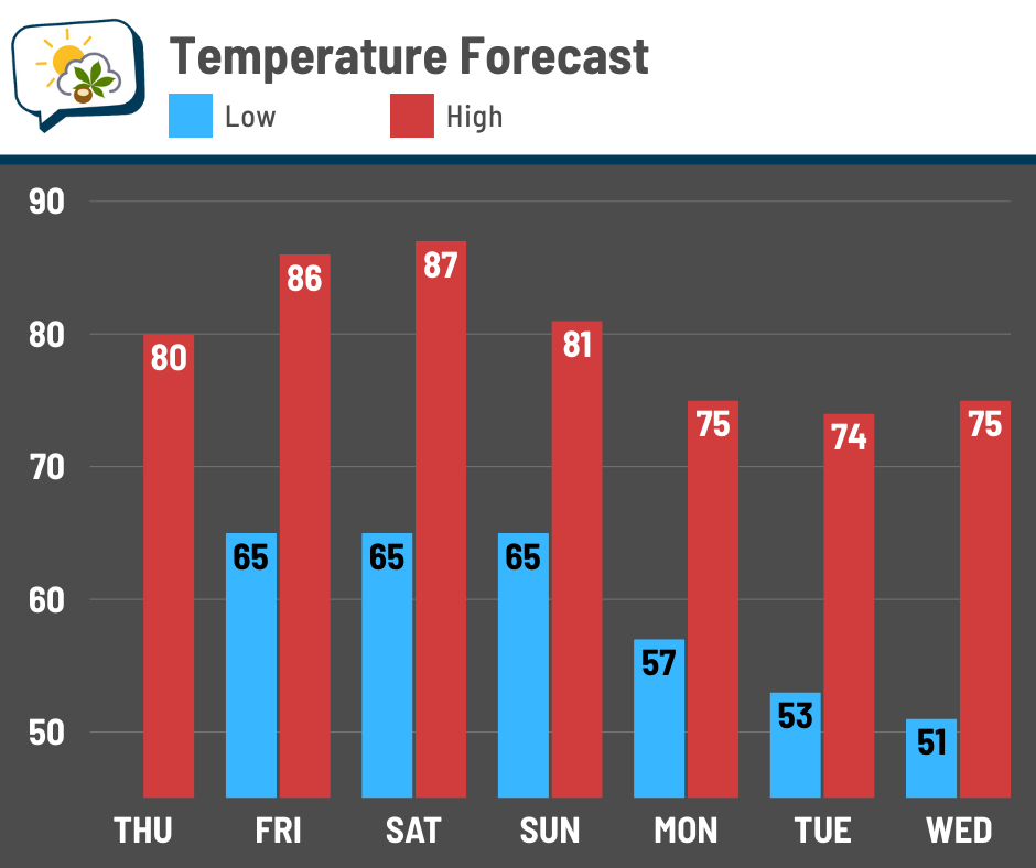
Highs will fall below normal, and for several days! Not only that, but the seasonable mugginess will be scoured out. Dew points stay in the mid-60s through Sunday morning, then fall and stay low deep into next week.
Early signs suggest we may have some northwest breezes at times next week, too, making it feel even more refreshing.
❌ Dry for a while
Some were lucky enough to get a passing thundershower Tuesday evening, although amounts were generally around a tenth of an inch or less. Southern Delaware County was the winner with several spots reporting roughly a half-inch.
We won’t see numbers like that again anytime soon.
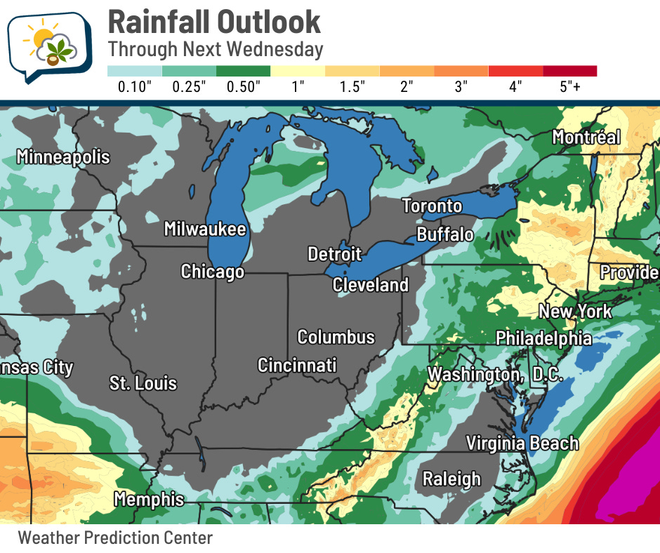
Aside from a slight chance that this weekend’s cold front could produce an isolated light shower, we have almost no opportunity for rain over at least the next week.
Beyond next Wednesday (the ending day for the map above), I don’t see much promise for rain as strong Canadian high pressure will remain in control. It’ll block moisture and prevent any noteworthy systems from coming through.
Some little pockets of dry conditions scattered about the state showed up in last week’s Drought Monitor update. This week’s update comes out this morning, and I’ll be curious to see if the authors expanded any of those.
📊 Today’s almanac
Normal low/high: 64 / 84
Record low/high: 44 (1950) / 99 (1936)
Sunrise/set: 6:49 a.m. / 8:19 p.m.
👋 Goodbye to warm, humid weather soon
The depths of summer are behind us — at least based on climatology. The graph below shows the daily frequency of having a high of at least 85, a dew point of at least 70, or both. (A value of 0.5 means it’s happened half of the years on record.)
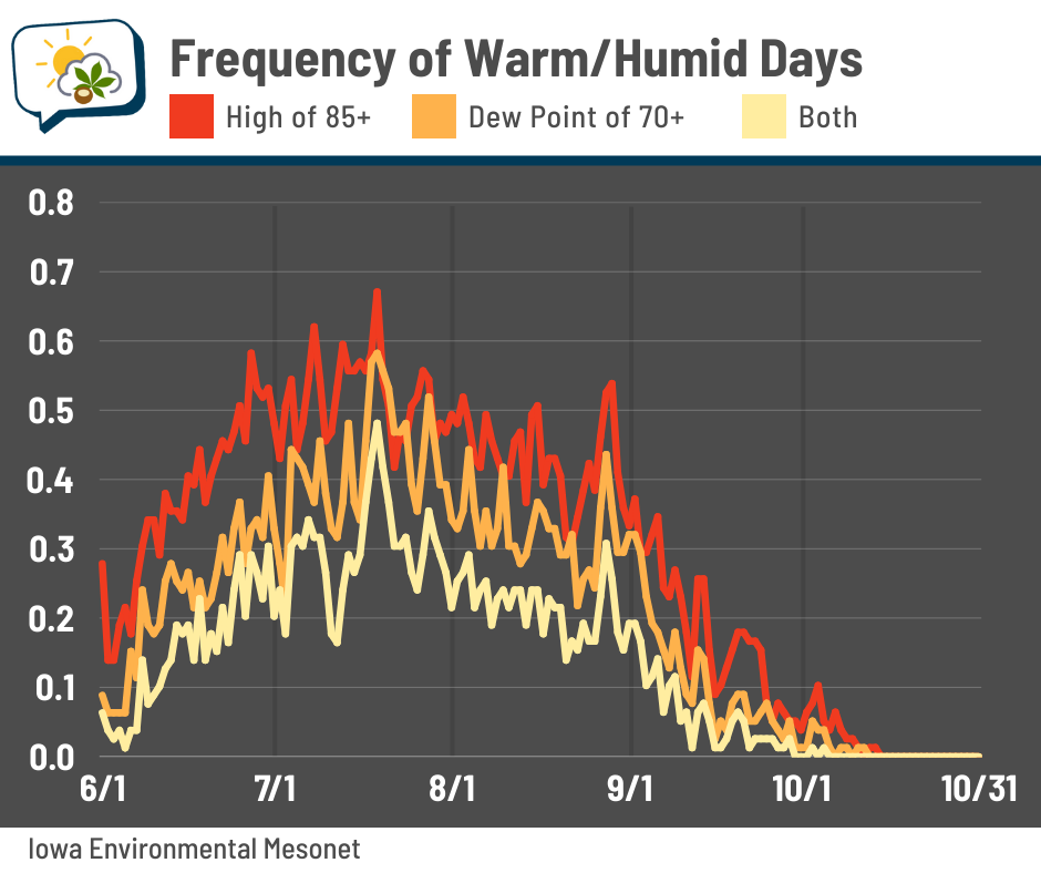
You can see that the odds of warm days, not surprisingly, peak during July; most days hit 85 at least 50–60% of the time. Super muggy days with dew points in the 70s happen roughly 40% of the time. Days when both conditions are met are also most frequent in July.
The daily odds gradually diminish a bit through August. Then look what happens in September — they tank. That’s especially true of super muggy days. The frequency of having both a warm and tropical day drops to less than 10% after about the first week of September.
🌭 For the weather weenies
-
Hurricane Katrina by the numbers, 20 years later (AccuWeather)
-
AI vs. wildfire: How tech is fighting flames before they spread (Climate Central/YouTube)
-
Trump admin strips ocean and air pollution monitoring from next-gen weather satellites (CNN)