The 614cast
Today’s tl;dr
☀️ Sunny, high near 80.

Forecast highlights
⬆️ Warm(ish) weather

After pushing to the neighborhood of 80 today, we’ll cross that threshold each day the rest of the week and into the weekend.
Here’s a “box and whisker” plot of the National Blend of Models temperature forecast. The gist here is that, when the boxes are short, there’s good agreement among the model output; when they’re taller, there’s less agreement and a bigger range of expected outcomes.
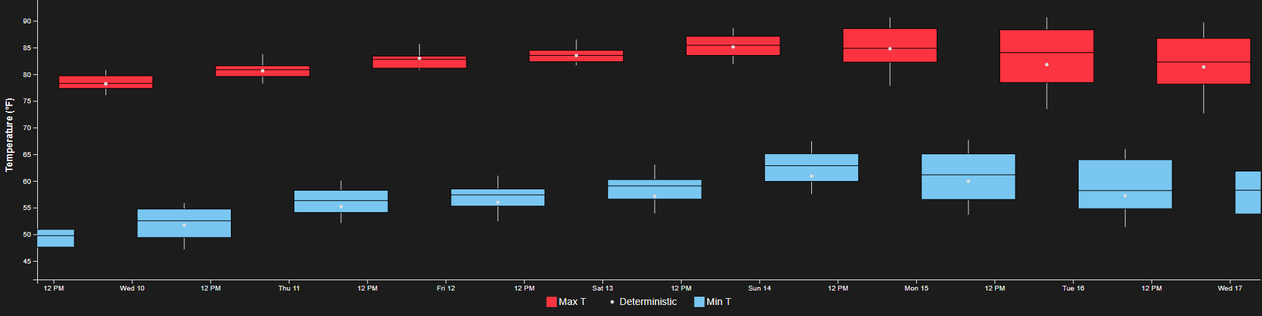
You can see the good agreement over the next few days as temperatures gradually rise. By early next week, there’s less agreement — although that’s typical, since we’re talking about weather that’s five-plus days away.
It’s still useful to see what that wider “reasonable” range is, though. The bottom of the boxes early next week are in the upper 70s, indicating that even if readings come down then, they’ll probably still be near or more likely a bit above normal.
What’s driving the warmer weather? A ridge of high pressure aloft. Here’s the forecast weather pattern for about halfway up the atmosphere:
Oranges/reds indicate the height of that layer is higher/deeper than average, which often translates to warmer temperatures.
We’re not in the epicenter of it, though. So while highs will indeed be above normal for several days, they won’t be exceptionally warm. Plus, dew points will only rise into the 50s later this week, which is still very comfortable.
It’ll be a touch of summer but with fall humidity.
📊 Today’s almanac
Normal low/high: 59 / 80
Record low/high: 39 (1883) / 95 (1939)
Sunrise/set: 7:07 a.m. / 7:49 p.m.
🌀 Peak of hurricane season
September 10 is the climatological peak of hurricane season, although the Atlantic is crickets right now.
This graph below shows how the average activity really picks up in August, peaks in September, and gradually diminishes as fall goes on.

This season has had six named storms; on average, an eighth would have formed by now. One of those tropical storms became a hurricane, behind the average of three hurricanes by this date.
Does the relatively slow start to the season portend a fairly inactive one overall? Not necessarily! You only have to go back three years to find a season that was considerably more active in the second half. At this point in 2022, we’d had only five named storms, but ended up with 14!
🌭 For the weather weenies
-
It’s the peak of Atlantic hurricane season, so why is it so quiet? (The Weather Channel)
-
125 years later, the Galveston hurricane is still the deadliest U.S. storm (AccuWeather)
-
Video of a glory while flying (Katie Mack/Bluesky)