Yesterday’s rain was the first since August 4, two and a half weeks ago. And over the previous month (and then some), we’ve had measurable rain twice… and one of those was a measly 0.01”.
CMH officially logged 0.27” from the late-afternoon storms, which prompted a Severe Thunderstorm Warning for parts of the eastern metro, the first in Franklin County since July 25. CMH recorded a 48 mph wind gust.
The 614cast
Today’s tl;dr
⛈️ Mostly cloudy with occasional showers/storms, high in the lower 80s.
Forecast highlights
☔ Periods of rain and storms
The ridiculous dry weather of late makes this week’s forecast all the more exciting.
First, though… Sherman, set the Wayback Machine to last week. Here’s the trend of average forecast rainfall for this week from the morning run of the National Blend of Models starting last Monday and going through yesterday:
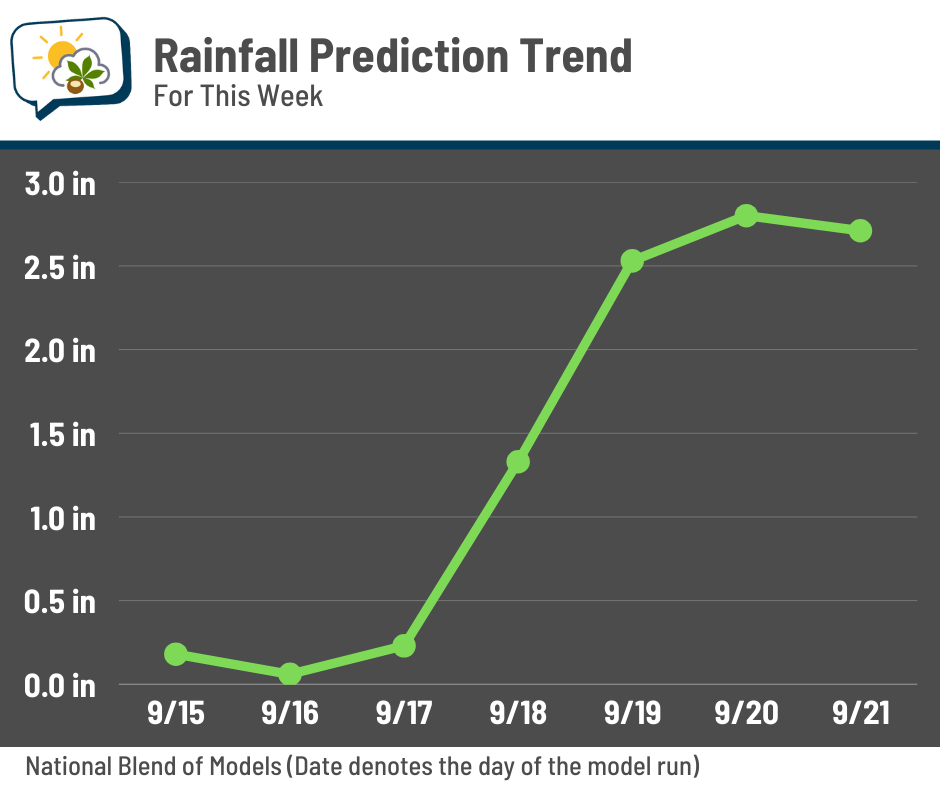
You can see that, through the middle of last week, it wasn’t much. Then the forecast jumped on Thursday (when I made my post for Friday, prompting me to consider being more optimistic about the rain prospects), and went even higher thereafter.
Thankfully, it still looks like we’ll have a good week. I still hesitate to get super on board with getting more than a couple of inches since I’ve seen drought situations lead to disappointing rain… but I’d rather undersell and be wrong a good direction. 🤣
Anywho, here’s the outlook from the Weather Prediction Center:
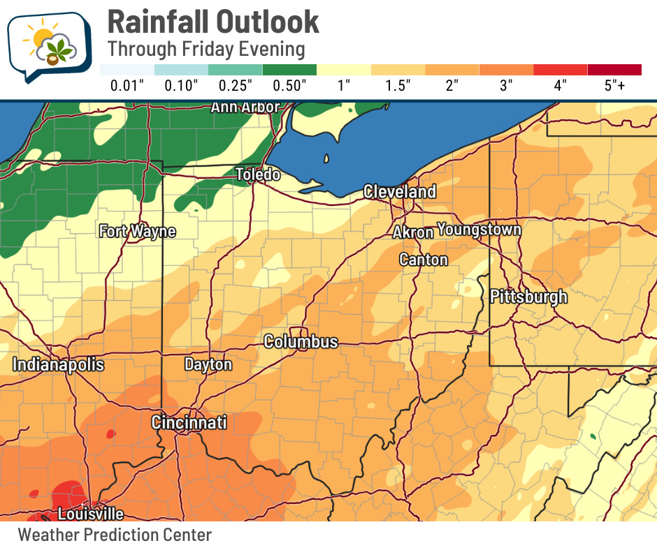
They’re painting about two inches in total this week. Bear in mind that’s spread out over a multiple days with occasional bouts of rain. Those rounds of rain will come as little impulses aloft ripple through the region, which are notoriously tricky to time out. But if your neighborhood gets underneath multiple thunderstorms, soak it in! You’ll have the best shot at exceeding a couple of inches.
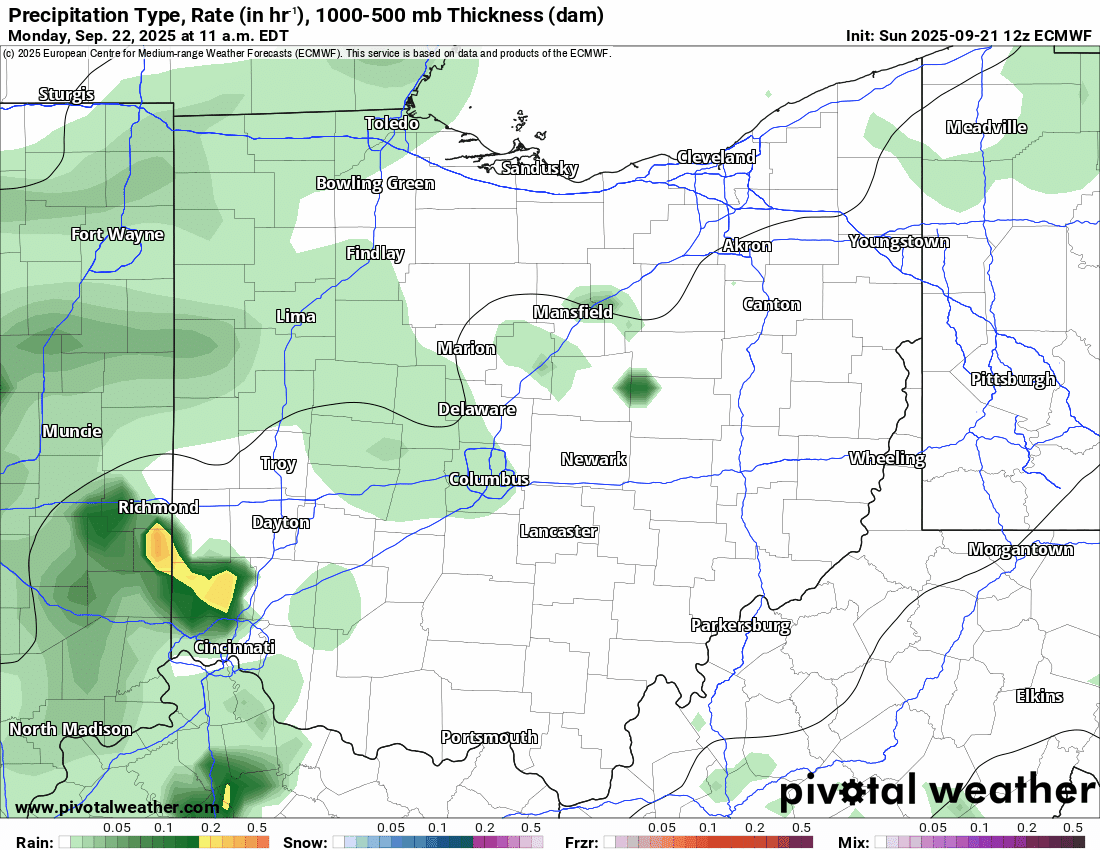
Here’s what things look like from the European forecast model at three-hour timesteps. Don’t expect for things to end up exactly as this shows, but instead use it to understand the overall theme of occasional activity. It looks like the bulk happens today and tomorrow, followed by a midweek lull, then perhaps a final hurrah late in the week.
💨 Gusty storms possible
A couple of storms this afternoon and evening could manage to produce gusty winds. As of yesterday, the Storm Prediction Center had most of the state in a marginal (level 1/5) risk of severe storms.
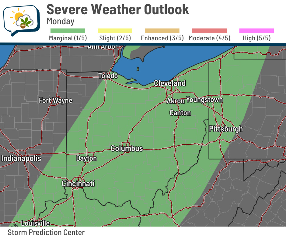
Go here for the latest outlook.
📊 Today’s almanac
Normal low/high: 54 / 76
Record low/high: 37 (1995) / 95 (1895)
Sunrise/set: 7:19 a.m. / 7:28 p.m.
🍁 First day of fall
Even though I contend that fall began on September 1, most normal people would say it begins today. Yeah, yeah, astronomical seasons are more popular than climatological seasons…
The equinox occurs at 2:19 p.m. ET this afternoon. That will be when the sun’s direct rays pass over the equator.
On the equinox, somebody standing at the equator would see the sun directly overhead at noon.
The Northern Hemisphere will be tilted away from the sun for the next few months, so its light will be less direct as daylight shortens and temperatures cool. On the winter solstice on December 21, the sun’s direct rays will reach their southernmost point (the Tropic of Capricorn), giving us our shortest day.

By the way, if you try to balance an egg or broom today because it’s the equinox, have fun. But try it again any other day and you’ll find that you can do it those days, too. It’s just a myth that the equinox produces special balancing properties.
Then again, if you’re a parent and need to keep your kid(s) occupied for a little while today…
🌭 For the weather weenies
-
What happens when major storms hit toxic dumps? (Moving Day)
-
COSI’s Dr. B demonstrates 3 science experiments families can do at home (10TV WBNS/YouTube)