The 614cast
Today’s tl;dr
🌧️ Mainly cloudy with periods of rain and a few thunderstorms. High in the mid-70s.

Forecast highlights
☔ Wet today with a few storms
Rain is back in central Ohio! We have a bunch of moisture around, so we could have some efficient rain-producers again. Some guidance suggests that very localized amounts of near 2” are possible, although most of us will be well under that.
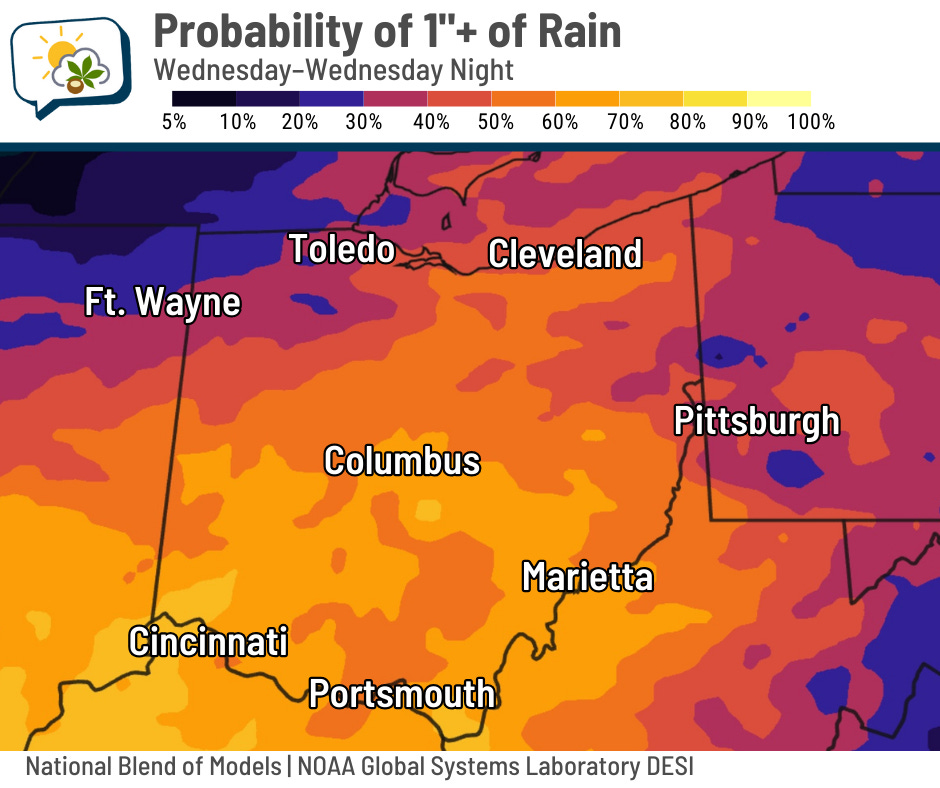
The National Blend of Models has about a 60% chance of getting at least 1” of rain.
NOAA’s Weather Prediction Center is forecasting about an inch of rain over the next few days, with the bulk of that happening today. I don’t foresee much tomorrow, and Friday will likely be dry.
If today’s activity trends farther south than anticipated, we’d come up short of this.
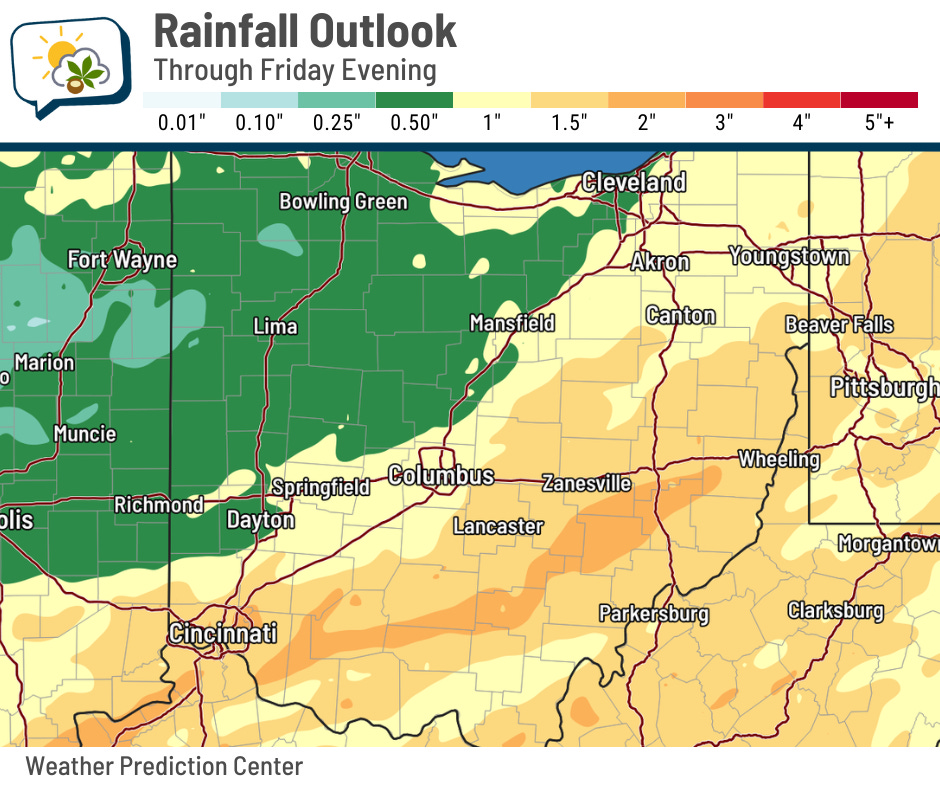
The better chance of higher rainfall is roughly south of I-70. A couple of inches is more likely there, which may lead to minor nuisance flooding in the usual trouble spots.
Our rain coverage ought to be greatest through about midday and generally lower thereafter.
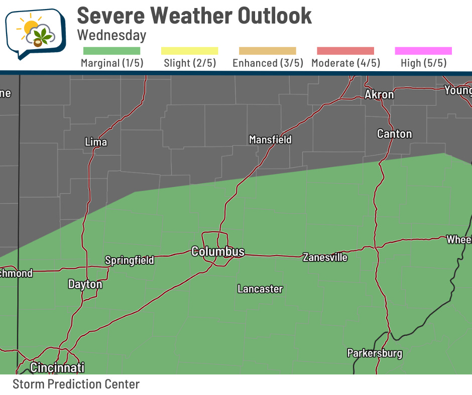
There’s also a low-end chance that a storm or two could produce gusty winds. The Storm Prediction Center’s afternoon update yesterday had us in a marginal (level 1/5) risk. Here’s the latest outlook.
🌡️ Relatively warm days ahead
Highs the next couple of days will be right about average, but we’ll warm up this weekend.

Highs near 80 will be several degrees above normal. We won’t have the same amount of mugginess by that point, though, as dew points will slip into the more comfortable 50s.
📊 Today’s almanac
Normal low/high: 53 / 75
Record low/high: 35 (1983) / 92 (2010)
Sunrise/set: 7:21 a.m. / 7:25 p.m.
💧 Precipitation breakdown
The official rainfall on Monday was 1.28”. Fall isn’t exactly known as a time when we have heavy rain, but it’s not exactly rare.
Check out this monthly chart of the number of times with at least an inch of precipitation (either rain or the liquid equivalent of snow) within a single calendar day.
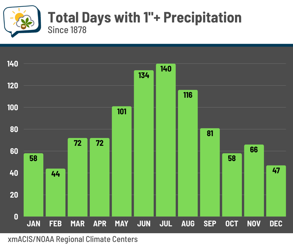
This includes nearly 150 years of records. You can see that days with a heavy rain are most common in the summer, averaging one nearly every year. Much of the reason is that warmer air “holds” more moisture, so it’s easier to get a bigger rain.
The flip side of that is that winter’s colder temperatures make it harder to get high amounts of precipitation. When you’re dealing with snow, it typically takes about 10–12” to get an inch of liquid equivalent (although wetter snows require less).
Normal monthly precipitation in the winter is less than in the summer, but the big difference is in how “bursty” that precipitation is. It’s far less so in winter compared to summer.
🌭 For the weather weenies
-
Hurricane Helene a year later: A long walk on Pinellas beaches (Axios)
-
Dust storms surprise the Midwest and raise worries about climate risks (Inside Climate News)
-
Purdue study uncovers why some hurricanes balloon in size and what that means for forecasting future storms (Purdue University Department of Earth, Atmospheric, and Planetary Sciences