The 614cast
Today’s tl;dr
☀️ Sunny, high in the mid-80s.

Forecast highlights
🌡️ Temperatures trend down as drier air filters in
Yesterday, I mentioned that reinforcing high pressure from Canada will dominate our weather later this week. It’s currently up toward James Bay, and will sink into the Northeast over the next few days.
Northeast flow will push drier air into our region, eventually knocking dew points back into the 40s. While we don’t really have noteworthy humidity right now (dew points in the 50s), that drier air will let morning lows cool a bit further… we should start off around 50 Thursday morning.
However, “return flow” on the west side of that high pressure will bring moisture back in from the south going into the weekend. Unfortunately, that doesn’t mean rain… but it does mean temperatures rise a bit again.
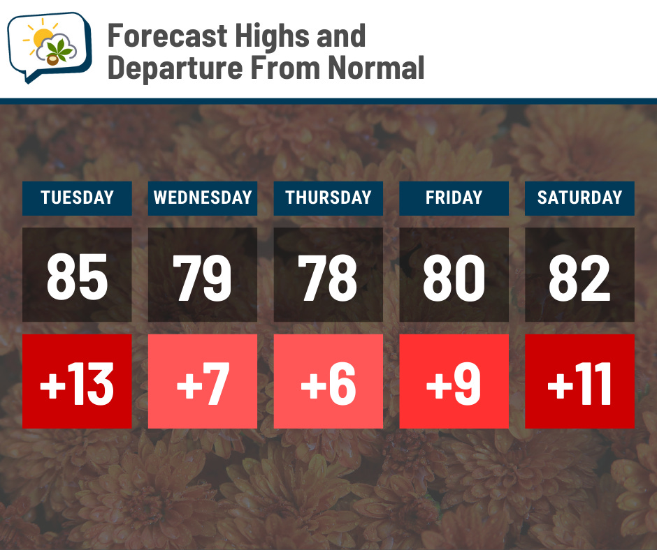
October is undoubtedly starting on a warm note.
🌵 Rain?
Instead of showing a map or graph with no rain on it, I figure I’ll change things up:
I clearly need a hobby other than writing this newsletter. 😆
📊 Today’s almanac
Normal low/high: 51 / 72
Record low/high: 31 (1963) / 92 (2019)
Sunrise/set: 7:27 a.m. / 7:15 p.m.
🎃 October normals
Yet another month has flown by… October begins tomorrow. Here’s a look at some of the stats for spooky szn.
🌡️ Normal high and low temperature
-
October 1: 72 / 51
-
October 31: 59 / 40
🌧️ Precipitation
-
Rain + melted snow: 2.90”
-
Snow: 0.2”
🌇 Sunrise and sunset
-
October 1: 7:28 a.m. / 7:13 p.m. (11 hours, 45 minutes of daylight)
-
October 31: 8:00 a.m. / 6:30 p.m. (10 hours, 30 minutes of daylight)
📊 Average number of days with highs…
-
80 or warmer: 3
-
70s: 8
-
60s: 11
-
50s: 7
-
Cooler than 50: 2
🌭 For the weather weenies
-
One-minute satellite imagery of Hurricane Humberto near peak intensity (Scott Bachmeier/Bluesky)
-
Atlantic hurricane season pulls off feat not seen in 90 years (FOX Weather)
-
FEMA is paralyzed. Disaster-torn communities are paying the price (Wall Street Journal)