➡️ Rainfall amounts on Sunday topped a half-inch throughout the metro and a handful of spots got near an inch. The top wind gust was 38 mph at the OSU Airport, with CMH not far behind at 36 mph.
The 614cast
Today’s tl;dr
☀️ Mainly sunny and a little breezy at times, high in the lower 60s.
Forecast highlights
🍂 Fall temperatures this week
Our daughter was born in late October eight years ago. When we left the hospital — the first time we’d been outside in only a couple of days — we were shocked at the very fall weather that had very abruptly arrived. It was like someone flipped a switch.
Jump forward to now. After having warmer-than-average temperatures with many 70s and 80s most of the past five-plus weeks, the switch flipped yesterday.
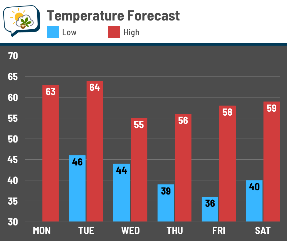
Nary a 70-degree high is in the forecast for the next week. In fact, it won’t even be that close, only peaking in the mid-60s tomorrow. Your eyes don’t deceive you; we have multiple days probably staying in the 50s later this week.
Friday morning should be the coolest of the bunch with lows in the mid-30s. We’ll certainly need to watch for frost risk that morning.
We’re between weather systems today, so it’ll overall be a nice fall day albeit a little breezy at times. Gusts top out around 15–20 mph, noticeable but lighter than yesterday. Occasionally windy weather continues through Thursday. It’ll certainly look and feel like fall this week.
🌧️ Couple of shower chances
We’ll be in a pattern that keeps some clouds around Tuesday onward… not overcast for days, but don’t plan on wall-to-wall blue sky, either.
A weak system passes through on Tuesday, bringing a chance of spotty showers. If we get anything, it’ll be light. I think the better chance of showery weather will be in northern Ohio.
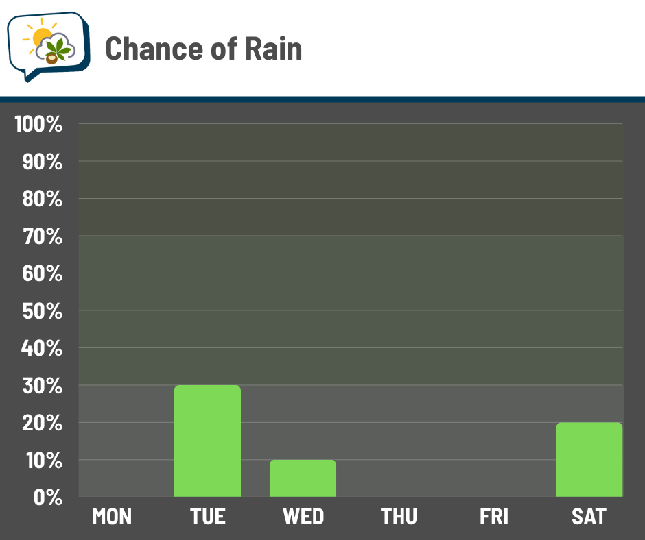
A little activity could bleed into Wednesday, but those odds are even lower.
For next weekend, rain chances could come up from my current forecast, but I don’t have much confidence in timing or the track of that weather system at this point. For now, though, it doesn’t look like it’d be a major rain producer for us.
📊 Today’s almanac
Normal low/high: 43 / 64
Record low/high: 24 (1972) / 84 (1953)
Sunrise/set: 7:48 a.m. / 6:44 p.m.
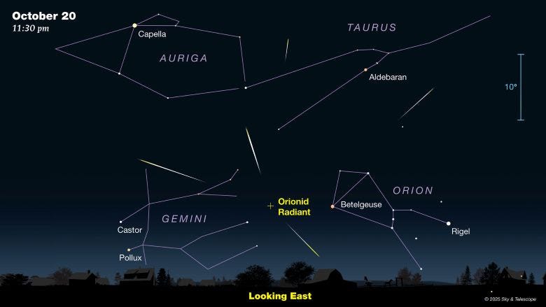
🌠 Orionid meteor shower peaks
You could see bits of debris from Halley’s Comet burn in our atmosphere this week as the Orionid meteor shower peaks. While the maximum occurs over the next few nights, tonight is your best shot from a weather perspective since we’ll be clouding up again soon.
In ideal conditions, up to 20 meteors per hour may be visible. Plan on the actual number being lower, though, even with no moon brightening the sky (since it’s a new moon, the opposite of full).
According to the American Meteor Society, you won’t be able to see anything until after 10 p.m. when the radiant — where the meteors appear to originate from — rises above the eastern horizon. The radiant, which is near the constellation Orion, will be higher in the sky between 1 a.m. and dawn, so meteors will be easier to spot then.
If you choose to take a gander, here’s a guide:
-
Keep expectations in check! Don’t plan to see a meteor every few minutes… it’ll likely be far less frequent.
-
Go to a rural location away from city lights.
-
Gaze toward the south or southeast, partway up from the horizon. Ideally, don’t have light pollution that direction.
-
Let your eyes adjust to the darkness for at least 10 minutes. Don’t look at your phone or other sources of bright light, because your eyes will have to reset if you do.
The Orionids are known for being zippy meteors, so keep your eyes peeled if you do try your luck. Dress for temperatures in the middle to upper 40s.
🌭 For the weather weenies
-
Columbus residents endure unpleasant smell amid dry weather conditions, aging sewer system (WBNS 10TV)
-
Deadly Alaska storm hit after a month of wider forecast errors (Bloomberg)
-
Alaska storm damage so bad many evacuees won’t go home for at least 18 months, governor says (NBC News)