I busted out the puffy coat yesterday.
… and a stocking cap.
Hey, I want to be comfortable when I go for my walk! This was our coolest day since April 11.
The 614cast
Today’s tl;dr
⛅ Partly to mostly cloudy and still somewhat breezy, high in the mid-50s.
Forecast highlights
🧊 Frosty mornings
As of me writing this Wednesday afternoon, central Ohio is in its first freeze watch of the season for Friday morning. I fully expect that’ll be upgraded to a freeze warning and/or frost advisory.
Winds will lighten enough tonight into tomorrow morning to allow areas of frost to develop, especially where readings dip closer to freezing. That’ll be most common in outlying areas, but even the city itself should get cold enough to allow for some patches of frost. (I consider 36 to be a good threshold for frost potential.)
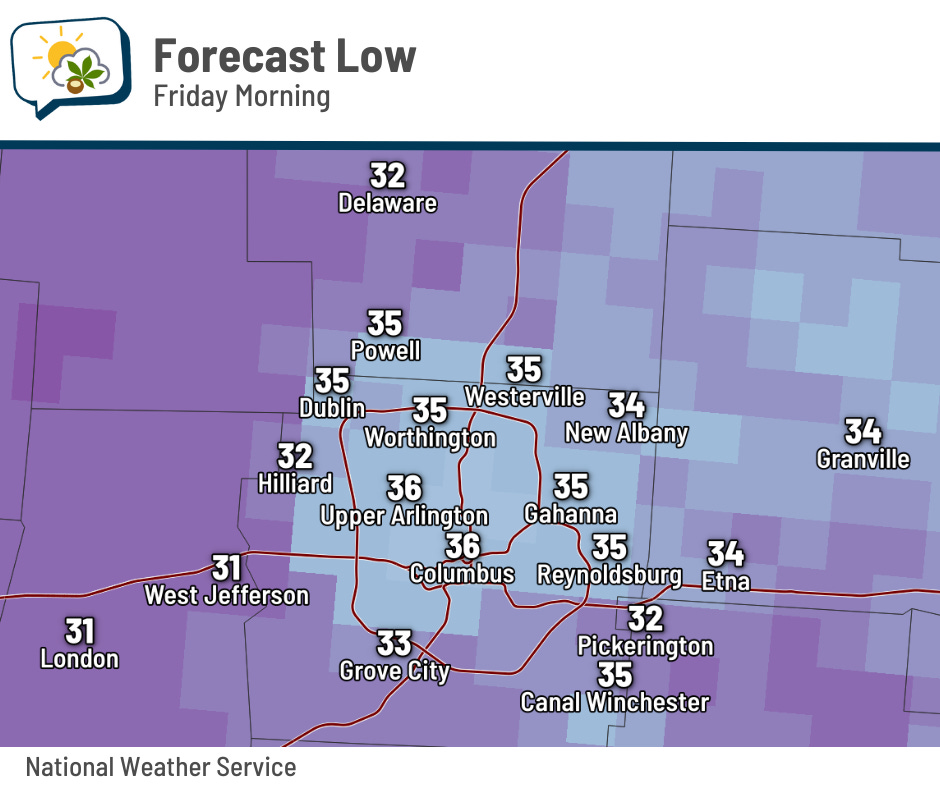
Saturday morning will host a similar situation, with lows in the lower 30s in outlying areas and mid-30s near and in the Outerbelt.
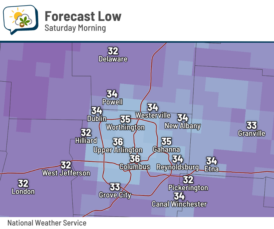
If you have sensitive plants that you want to live on, you’d be wise to protect them the next couple of nights. Move them inside or cover them with a light cloth sheet.
👆 Temps tick up
I know I was betting on the under for highs yesterday, but even my pessimistic expectation wasn’t enough. Temperatures essentially did not move all day… so much that the high of 51 was actually at 2:41 a.m. We were locked at 48 or 49 throughout the daytime.
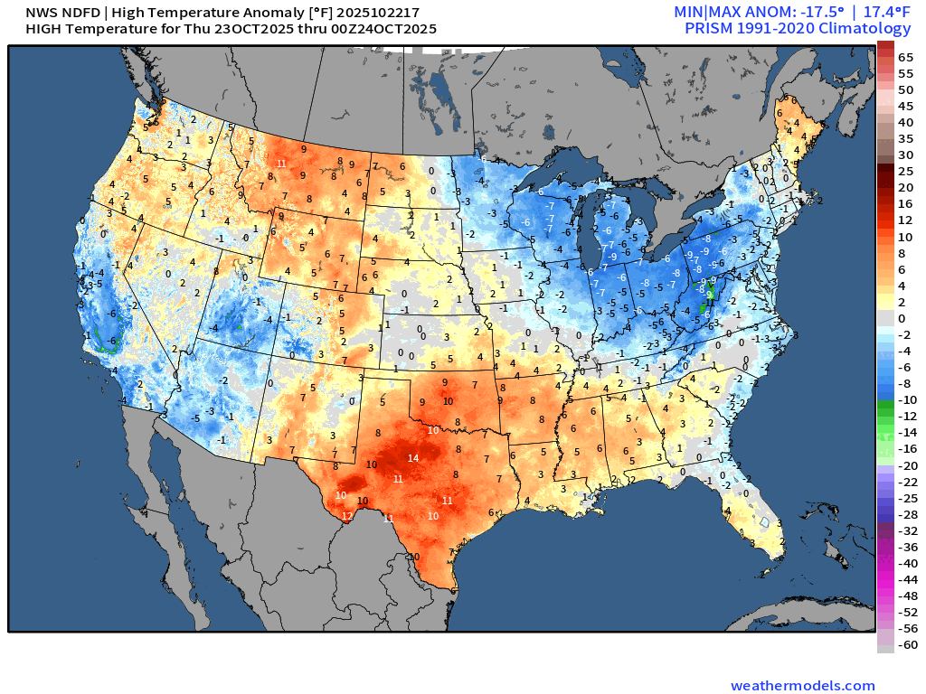
Temperatures will gradually warm, although the word “warm” is doing a heavy lift in this sentence. In this animation of daily high temperature anomalies, you can see the blues steadily be replaced by yellows in our neck of the woods.
This weekend’s highs should be in the upper 50s to around 60, unimpeded by the threat of rain. That shower chance has all but fizzled.
Odds favor above-average temperatures to finish out the month.
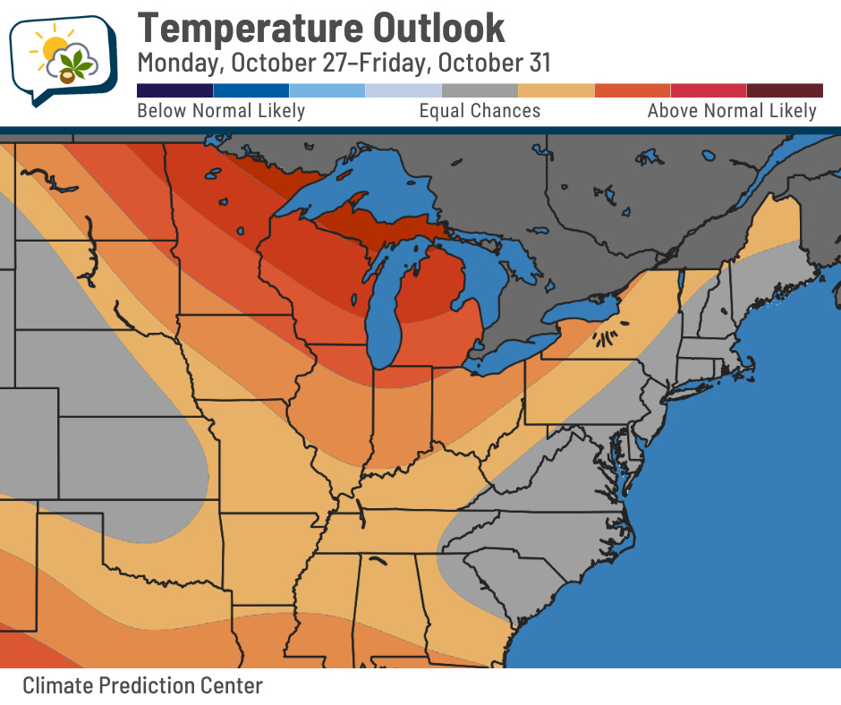
To reiterate a point I’ve made before, though: Warmer than average doesn’t necessarily mean “warm” anymore. Our normal high slips to 59 on October 30, so cracking 60 is technically above average! The warmest we’ll get is maybe the lower 60s early next week.
📊 Today’s almanac
Normal low/high: 42 / 63
Record low/high: 23 (1969) / 83 (1947)
Sunrise/set: 7:51 a.m. / 6:40 p.m.
⛄ Frosts and freezes
The threat of frosty weather is a sign of the season… and we’re actually running behind schedule a bit.
The average date for the first frost (36 degrees) is October 14. I’m using the 1991–2020 climate normal period for that… but the date has been shifting later and later over time. In the graph below, the line shows a loose downward trend, indicating the first frost trending deeper into October than it used to be.
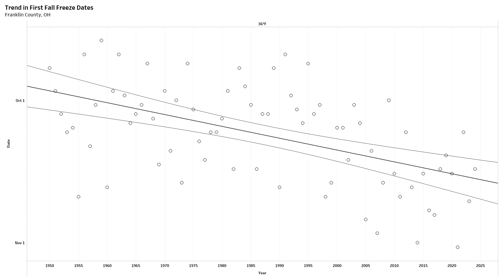
The earliest 36-degree low was September 18, 1959; the latest was November 5, 1927.
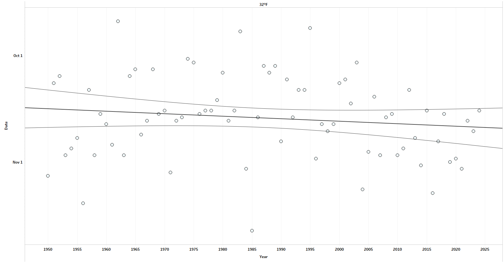
For a freeze of 32 degrees, the average first date is October 25. The earliest was September 21, 1962; the latest was November 27, 1902.
The date of the first freeze has also been trending later, although it’s not as pronounced.
You can nerd out with the Midwest Regional Climate Center’s Freeze Date Tool here.
🌭 For the weather weenies
-
Now at Climate Central: U.S. billion-dollar weather and climate disasters (Climate Central)
-
Weather balloon cracks United Airlines cockpit windshield (NBC News)