The 614cast
Today’s tl;dr
⛅ Partly cloudy and sometimes breezy, high in the upper 50s.

Forecast highlights
☔ Waiting for the wet
Enjoy today, because change is a-comin’.
A weather system is developing off to our west today and will hook north along the Appalachians Wednesday into Thursday, bringing rain and cool temperatures.
Here’s how the European forecast model plays things out, showing the low pressure system and the forecast radar.
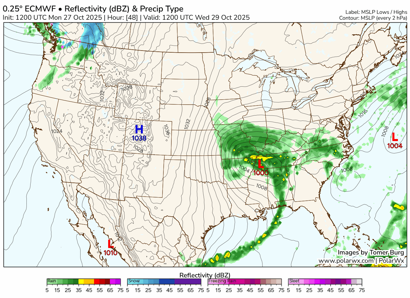
Rain spreads in from the south on Wednesday, with the best chance coming in the afternoon and especially evening. Rain remains likely on Thursday, perhaps starting to become lighter and somewhat more scattered in the evening… maybe. I hope it does, so I am not soaked carrying an umbrella over our trick-or-treater.
Regardless, much of Thursday’s going to be pretty wet. You can see high rain odds throughout the day.
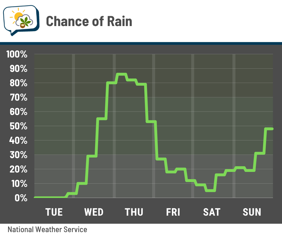
With cool air aloft, spotty showers could pop up again Friday, mostly in the afternoon.
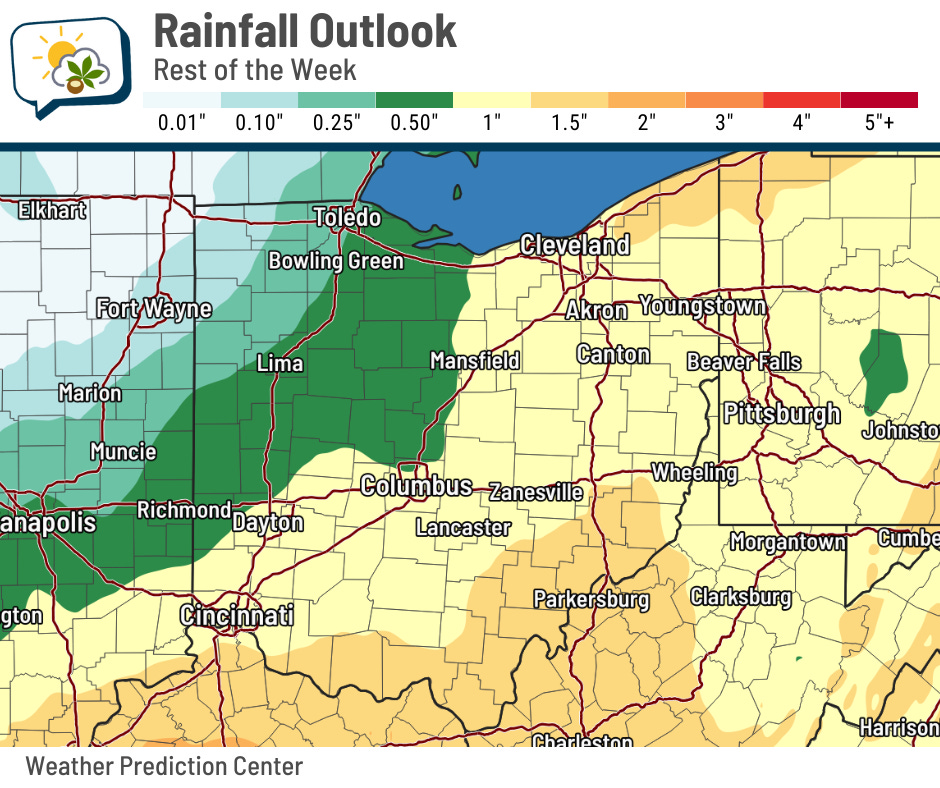
Chances are pretty good that we’ll see rainfall in the neighborhood of an inch. This will continue helping remove some of the lingering dry conditions in central Ohio. Unfortunately for the drought-stricken parts of northwestern Ohio, rainfall amounts will be less there.
🧥 Cool times ahead
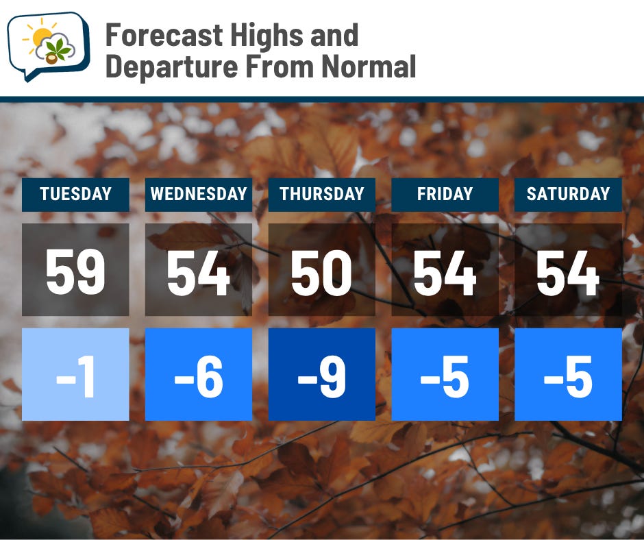
Today’s going to be pretty close to average. After that, cool air dominates. Thursday’s forecast of 50 could be a struggle to reach; I wouldn’t be surprised if I have to pull that down a little further.
It also won’t be unusual for winds to gust to at least 20 mph, especially starting tomorrow through Friday. That’ll add an extra chill, particularly on Thursday.
📊 Today’s almanac
Normal low/high: 41 / 60
Record low/high: 21 (1976) / 81 (1927)
Sunrise/set: 7:56 a.m. / 6:34 p.m.
🌀 Jamaica’s worst direct hit on record
Hurricane Melissa continued strengthening yesterday and even had estimated top sustained winds of 175 mph, putting it among some of the most powerful storms on record in the Atlantic basin.
And Jamaica is still in its crosshairs as the hurricane crosses the island today, producing destructive winds, incredible rainfall, and powerful storm surge. Here’s the latest from the National Hurricane Center.
This will undoubtedly be the most intense storm known to hit the island. Below are the paths of “major” hurricanes (Category 3 or stronger on the Saffir-Simpson Hurricane Wind Scale), from NOAA’s historical hurricane tracks tool. (Here’s the link for the map below.)
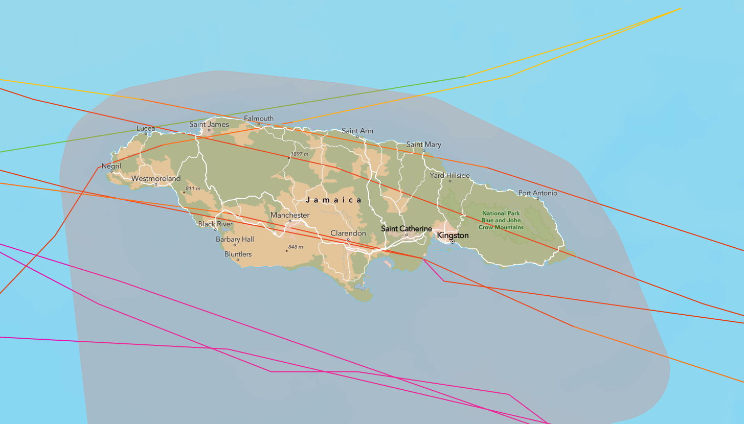
A few have made direct landfall on the island, while others had indirect impacts as they passed just to the south.
The strongest to make landfall was Hurricane Gilbert on September 12, 1988. It had top estimated sustained winds of 130 mph, and a weather station northeast of Kingston recorded a 121 mph wind and gusts approaching 150 mph. Over 30” of rain fell in some of the mountainous parts of the island.
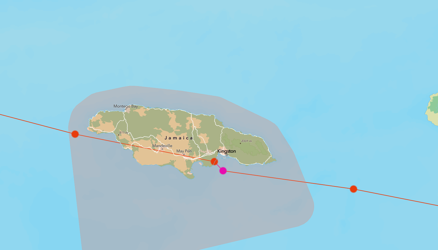
At least 45 people died and damage topped $2 billion, according to some estimates.
You can read a bit more about Gilbert’s impacts to Jamaica here.
🌭 For the weather weenies
-
Sunrise to sunset satellite loop of Hurricane Melissa on Monday (CIRA/Bluesky)
-
Hurricane Melissa and climate change (Climate Central)
-
Jamaica’s crazy mountains will make Hurricane Melissa even more dangerous (TheGeoModels/YouTube)
-
Jamaica has a rich hurricane history but has avoided most powerful storms (AccuWeather)