The 614cast
Today’s tl;dr
🌤️ Sunny morning, then increasing clouds. Much lighter wind, high in the mid-50s.

Forecast highlights
⛈️ Springlike(?) Friday
Since we have a quiet, seasonable early-November day today, let’s jump ahead to tomorrow.
I know it might seem a little odd to describe it as springlike (hence the question mark), but it’ll have that kind of feel. Breezy, high in the lower 60s, and relatively humid for the time of year.
Check it out — dew points jump into the mid-50s for the afternoon and evening.

That will fuel the showers, which ought to approach by late morning and continue into the afternoon, probably wrapping up in the evening.
Rainfall amounts have continued to trend downward, with most guidance settling toward a quarter-inch or a bit more.
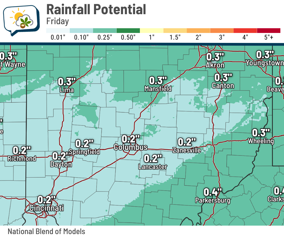
In hindsight, I should have expected such a trend. Despite a pretty good level of moisture drawn into the region, the amount of time we’ll actually have rain in the area will be limited compared to recent rounds.
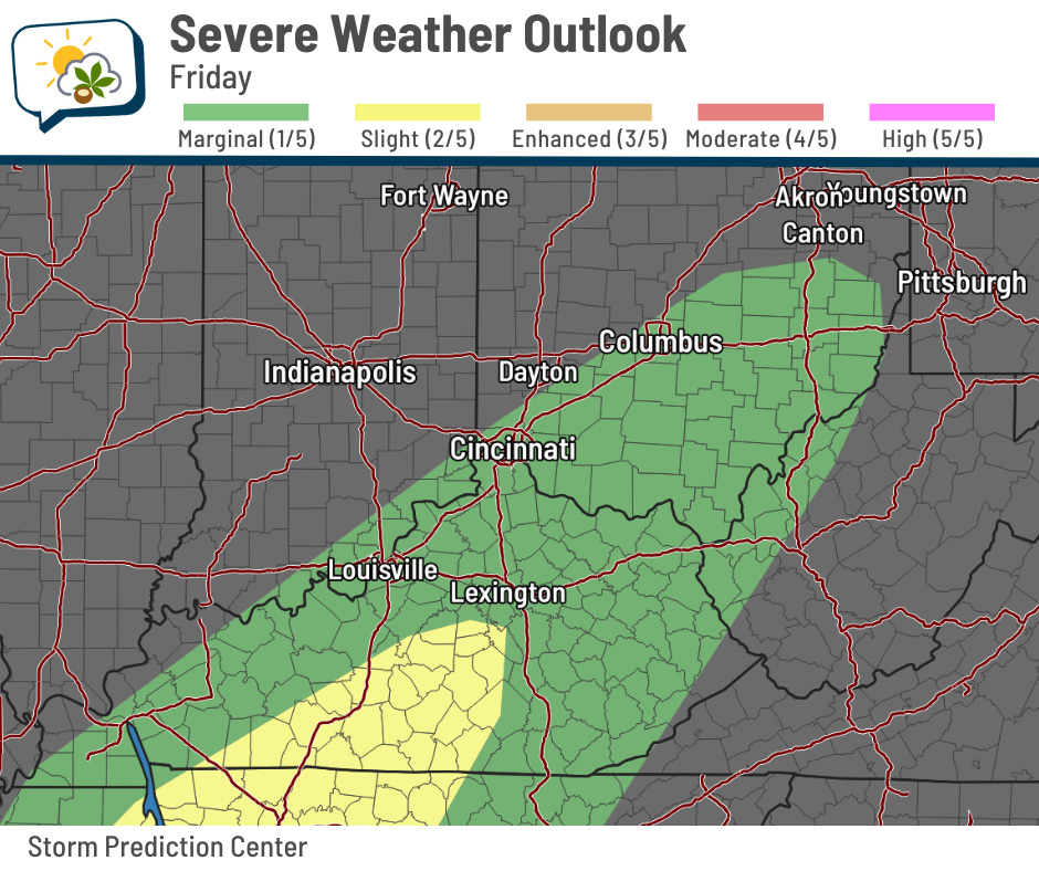
We could also manage a rumble or two of thunder. The Storm Prediction Center even had roughly the southeastern half of Ohio in its marginal risk (level 1/5) of severe weather in the outlook issued yesterday, with higher odds to our southwest in Kentucky and Tennessee. (Check the latest outlook here, since it’ll have been updated since I wrote this.)
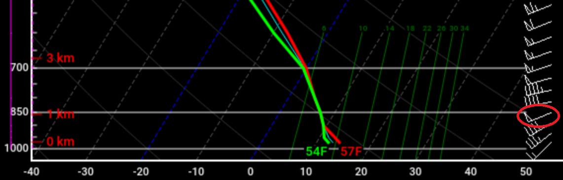
The potential for general storms is iffy, let alone for anything strong to severe. There’s a lack of unstable air to really give activity some “oomph.” But there’s plenty of another ingredient: shear. That’s the change in wind speed and/or direction with height.
And not far aloft — roughly 3,000 feet off the ground — wind speeds are forecast to be near 50 knots, or 58 mph. It wouldn’t take a lot to mix some of that wind down to the ground.
I’ve noted the 50 knot wind barb in the image below. 🤓 Nerd alert… this is a “forecast sounding.” It’s basically “what does the model think a plot of weather balloon data would look like at this time and place?” It shows temperature (red), dew point (green) and wind barbs (right-hand side) with height.
But even if there aren’t any robust showers or a thunderstorm that develop, it’ll still be windy. Similar to yesterday, expect sustained winds of 10–20 mph and gusts perhaps topping 30 mph.
⬇️ Here comes the cold
Uggggh I am not ready for this. Alas, it is November… doesn’t make the bitter pill any easier to swallow, though.
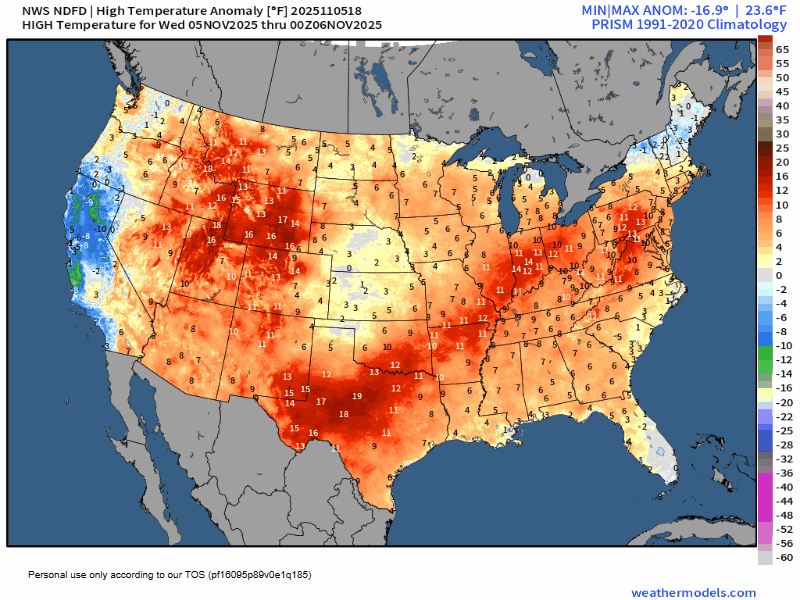
Here are the forecast high temperature anomalies through next Tuesday. You start to see the chill emerge in the Northern Plains and parts of the Upper Midwest on Saturday, then spill south and east. It’ll dominate essentially the entirety of the country east of the Rockies on Monday.
Monday is also when the core of this cold blast is right on top of us. Temperatures fall through the 40s during the day Sunday and may not reach back to 40 on Monday. Even if they do, it won’t matter because wind chills will struggle to get past the freezing mark.

The chunk of energy that drives the cold air will also generate some off-and-on precipitation Saturday night through early Monday, as it looks now. It’ll be light, but wet snowflakes are possible later Sunday and thereafter.
If you’re as not-thrilled as I am about this, don’t despair. Highs should return to more seasonable 50s for the back half of next week.
📊 Today’s almanac
Normal low/high: 38 / 56
Record low/high: 20 (1953) / 77 (1975)
Sunrise/set: 7:07 a.m. / 5:23 p.m.
🎃 October review
We finally got some good rain last month, which eliminated the drought conditions that had developed. Temperatures were also warmer than average, overall.
-
Average high: 67.7 (2.2° above normal)
-
Average low: 46.8 (2.0° above normal)
-
Average temperature: 57.2 (2.0° above normal)
-
Precipitation: 3.88” (0.98” above normal)
-
Snowfall: 0.0” (0.2” below normal)
The superlatives:
-
Warmest high: 85 on the 4th
-
Coolest high: 51 on the 22nd and 30th
-
Warmest low: 59 on the 7th
-
Coolest low: 34 on the 24th and 25th
-
Rainiest: 1.84” on the 7th
And a few other numbers…
-
Consecutive days of 80-degree highs: 5 — most since 2018
-
Highest wind gust: 42 mph on the 21st
-
Days with at least 1” of rain: 2
🌭 For the weather weenies
-
Philippines devastated by deadly flooding from typhoon, another is on its way (AccuWeather)
-
California surface water costs triple during drought (University of California, Davis)