Today’s newsletter is a little late… I ran out of time to finish it yesterday and was at Thursday night trivia a little later than usual. 🤓 (Come out to Endeavor Brewing on Thursday evenings! It’s a Family Feud-style game. Nobody’s giving me anything to say this, I just enjoy going out for it.)
The 614cast
Today’s tl;dr
⛅ Sun early then increasing clouds, high in the upper 50s.

Forecast highlights
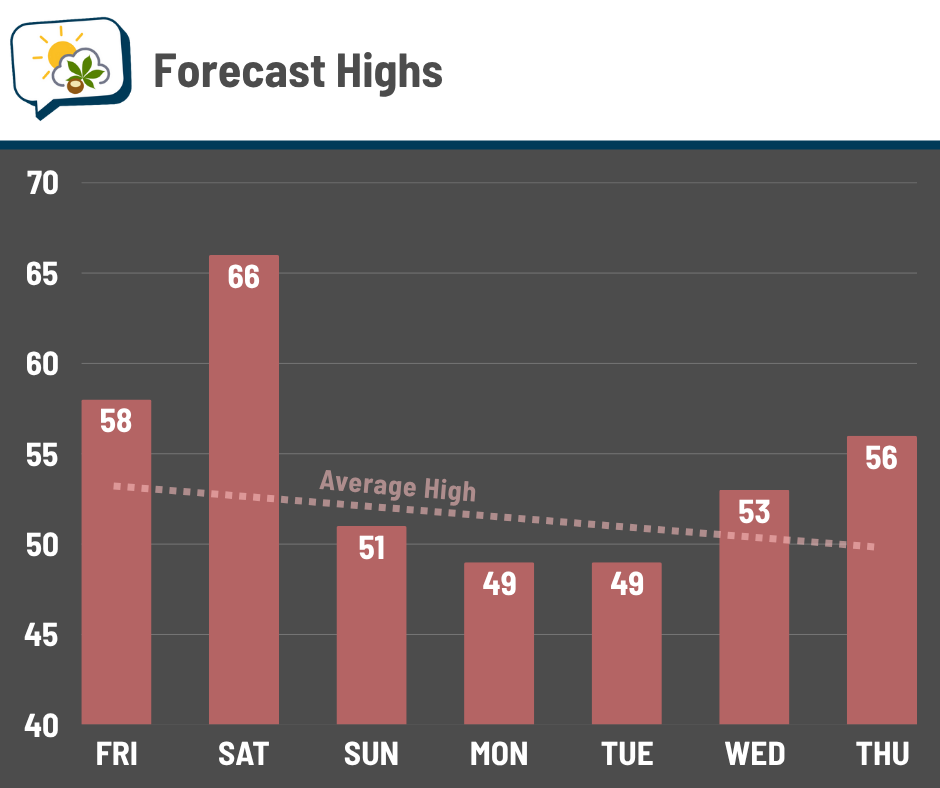
🎢 Mixed bag this weekend, unsettled next week
Today’s going to be another nice day with fairly light winds and highs in the upper 50s, although clouds will increase later on. Tomorrow’s even warmer — two Saturdays in a row with highs in the 60s! Not too shabby for November.
Gusty southwest winds will help drive the warmup. But the cold front timing allows cooler air to pour in with plenty of time for Sunday, so northwest winds into Sunday drop things right back down. Lower 50s will be about all we can muster, even with sunshine.
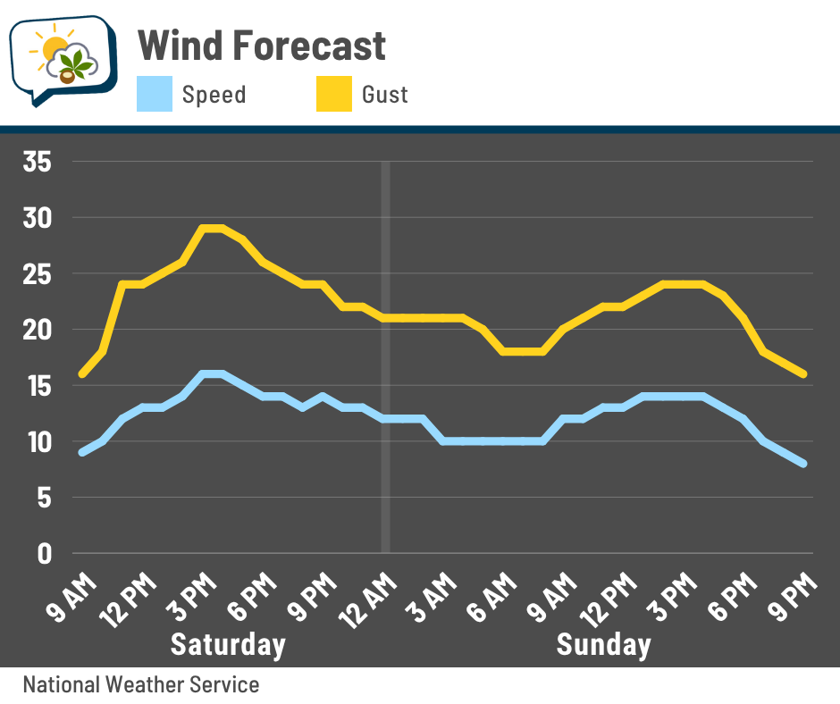
Ahead of the cold front that pushes through Saturday night, a handful of showers are possible. However, the ingredients are not great. If any activity happens, it looks isolated and short-lived.
The Buckeyes kick off at 7:30 Saturday night… stuff might very well be past by then, but if not, it should come through with little fanfare other than a quick shower and maybe an uptick in wind gusts as it passes.
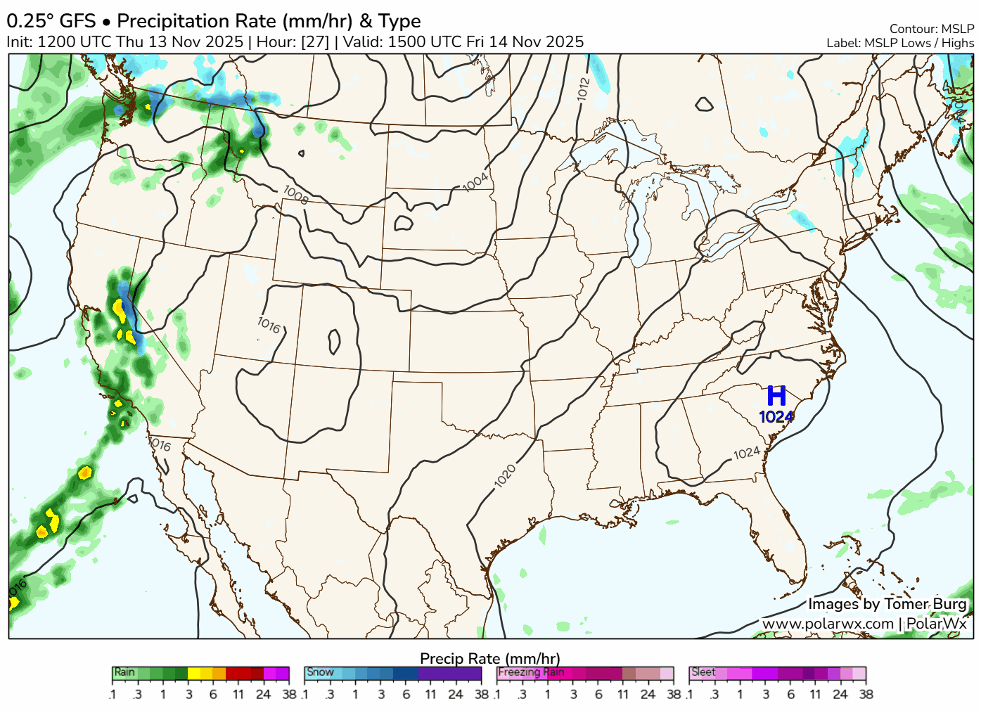
Below is the weather map through next Thursday evening. It starts this morning and takes a pause Saturday evening… you’ll see that most of the action is in southeastern Ohio.
Another disturbance passes to our south early Tuesday. We may be brushed by the northern edge of a rain/snow mix, but it won’t last very long. Then a warm front lifts our way Thursday, perhaps bringing a broader shield of rain ahead of it.
That’s a ways out, though, with time to refine the details.
📊 Today’s almanac
Normal low/high: 35 / 53
Record low/high: 12 (1986) / 74 (1909)
Sunrise/set: 7:16 a.m. / 5:16 p.m.
🌡️ Mild after cold
CMH fell to 24° on Monday morning, the coldest temperature of the season so far. How warm have we gotten in the past after having the first sub-25 low? Since I’m asking the question, you know there’s an answer. 😄

The top plot is showing the highest temperature to occur in each year after the first time falling to 24 or colder. In Columbus, that’s 82° in 1964. That might seem strangely warm, but that year had an early cold snap. The temp fell to 24° on October 11, followed by the 80-degree day on October 17.
The middle plot shows the highest temperature, but by date. You can get a sense of a little bit of a downward line from left to right, which makes sense. If such a cold temperature happens earlier, there’s more time to have a warm rebound. If it first happens in December… well, there’s not much temperature runway.
The bottom plot shows the number of days each year with a high of at least 60° after the first low of 24° or colder. 28 years had zero days, while the most was 1964 (again, that was the earliest) with 31 days. You can see how much of an outlier it was; second place is 19 days.
2025 is denoted in red. Of course, the stats for this year look pathetic since it just happened.
By the way, 122 years failed to hit 70° after the first time dropping to at least 24°.
🌭 For the weather weenies
-
Why home insurance is unaffordable, even in places without wildfires or hurricanes (NPR)
-
U.S. tsunami warning system, reeling from funding and staffing cuts, is dealt another blow (NBC News)
-
These cows could be dairy industry’s climate game-changer (The Weather Channel)