The 614cast
Today’s tl;dr
🌧️ Occasional rain, high in the mid-40s.
Forecast highlights
☔ Two rounds of wet this week
Blah.
That describes today’s weather. Here’s the forecast radar from one of the high-resolution models:
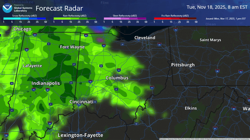
You’ll notice it’s all green here, indicating rain. It still looks unlikely that there’ll be much if any wet snow mixing in with the onset of precipitation, but I can’t completely rule out a short-lived slick spot or two (bridges/overpasses) in outlying areas if temperatures drop to freezing.
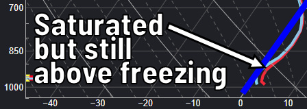
Let’s get nerdy about why… the following three images are forecast soundings, or what a model thinks a weather balloon’s data would look like. Light blue is dew point, red is temperature, and dark blue is the freezing mark. The bottom is the ground, and the top is about 10,000 feet up. Left is lower temperature, right is higher temperature.
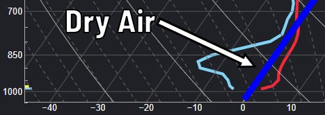
Earlier this morning, at 5 a.m., there was a big separation between the dew point and temperature. That indicates a wedge of dry air. That can delay the onset of precipitation, and it can also cool the air through a process called “evaporative cooling.” Think about when you hop out of the shower and feel chilly — same thing! It’s also how your body regulates its temperature through sweating.
You’ll notice the temperature is also to the right of, or warmer than, freezing for most of those 10,000 feet. Above freezing for that amount of atmosphere = too warm for snow, if there were to be any precipitation.
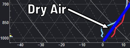
Let’s go forward a few hours to 8 a.m. That dryness has eroded somewhat as the shield of precipitation continues spreading into central Ohio, and the temperature aloft has cooled a little, too. But it’s still above freezing, so still rain.
Let’s end this little lesson at noon. We’ll be saturated by then, which means there’s no dry air left to do any further cooling. Yet we’re above freezing, so still solidly rain… a chilly rain, to be sure, but rain nonetheless.
Periods of rain come throughout the day, tapering off tonight. Unfortunately, cloudiness will reign supreme between then and our next weather system late this week.
It still appears we may avoid rain until at least after sunset Thursday, but that’s still not a for-sure. Friday and Friday night ought to be pretty wet, with showers winding down by early Saturday.
Here’s an early look at what the National Blend of Models’ average is spitting out.
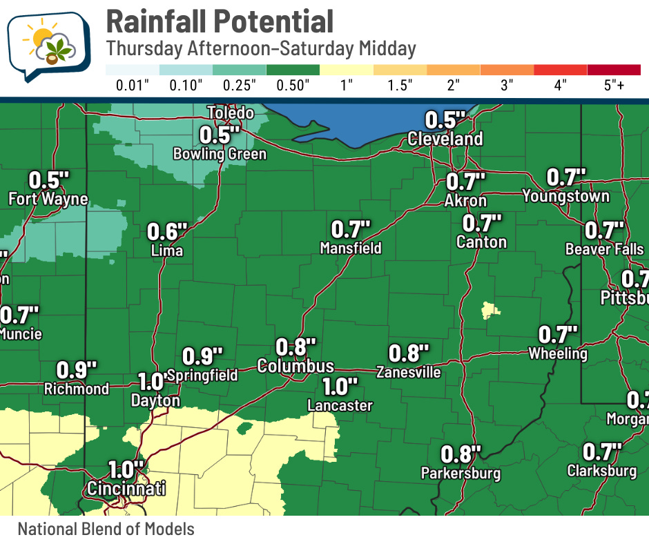
The path of the system will dictate how things go, but it appears that the higher amounts should be to our south, much like with today’s rain.
📊 Today’s almanac
Normal low/high: 34 / 51
Record low/high: 10 (1880) / 75 (2016)
Sunrise/set: 7:20 a.m. / 5:13 p.m.
🌇 Earliest sunset is less than 3 weeks away
Mark your calendar for Sunday, December 7. But only if you’re into putting things on a calendar that are really specific and weird, like “earliest sunset of the year.”
Sunset that day is 5:06 p.m., a mere seven minutes earlier than today! We’re almost there!
To be fair, sunset is 5:06 from December 3–11, but the 7th is the earliest earliest.
The 21st is the solstice and day with least daylight, and January 4 is the latest sunrise (7:53 a.m.).
If you’re wondering why the latest sunrise and earliest sunset don’t both land on the solstice… that’s a topic all unto itself. 😉
🌭 For the weather weenies
-
Acting FEMA head resigns (NBC News)
-
The dead zones: By mid-century, many places in the United States may be uninhabitable (The Atlantic/Instagram)