The 614cast
Today’s tl;dr
☁️ Cloudy, high in the lower to middle 50s.
Forecast highlights
🌧️ Still a tricky rain forecast
Friday’s rain situation is still clear as mud. There are still two camps: one wet, one mostly dry.
The American model has a weaker high pressure in the Upper Midwest compared to the European model, which allows the next weather system to take a more northerly route right through Ohio. The European model’s stronger high pressure shoves the system’s path across Kentucky and also funnels in some dry air aloft, helping to chew away the northward extent of the rain.
The video below starts with the American forecast model, followed by the European one. The differences in the overall pattern are subtle, yet the consequences are significant.
The European model gives us almost no rain, while the American model is well over a half-inch. The American model’s “ensemble” of rainfall forecasts, shown below, also shows a fair amount of clustering around a half-inch, give or take.
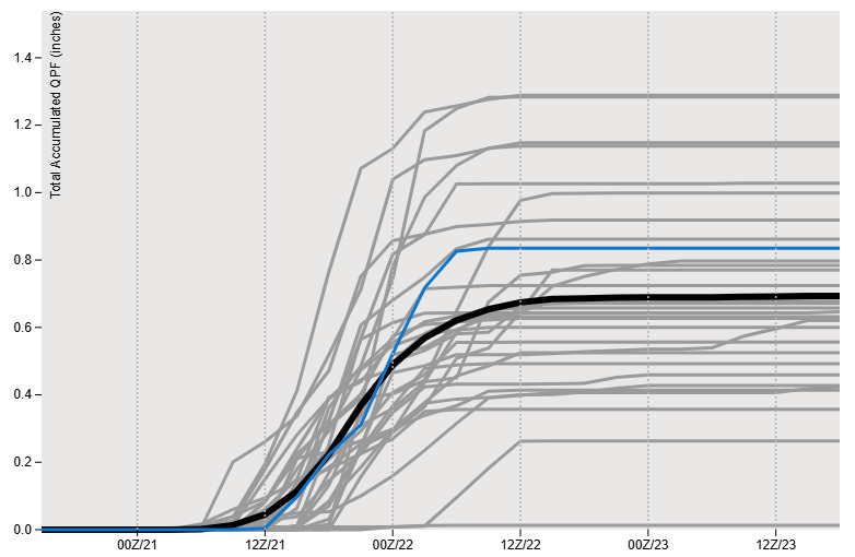
Unfortunately, I don’t have a similar breakdown for the European ensemble, but its the average rainfall is more than nothing. 😅
Something I found curious is that the AI flavor of the American model hedges toward the European model solutions. If that’s how things end up, it’d be a little feather in the cap for the AI model.
I’m surprised there’s still this much disagreement so close to an event. It looks to me like both models have a pretty good grasp of the current situation, so their deviation is a little frustrating. It also doesn’t help that the parent disturbance, currently located in the Southwest, kind of washes out as it slides toward us.
My position at this point is that rain is more likely than not on Friday, the heavier/steadier stuff will be to our south, and there could be a fairly sharp cutoff on the northern edge of the rain shield.
🌡️ Relatively mild for now
Biting cold isn’t in the cards in the near future. Highs will be near to above average straight into next week.
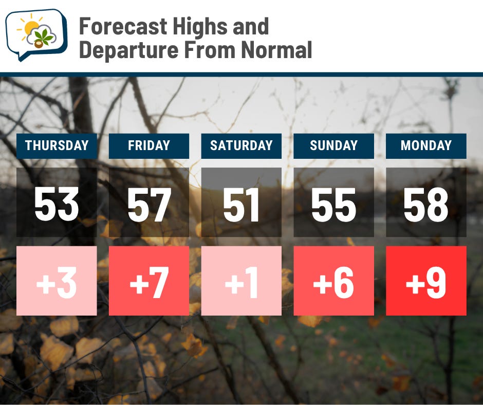
Things ought to change long about Thanksgiving as signs point to colder air sweeping in. Until then, enjoy the seasonably mild weather.
📊 Today’s almanac
Normal low/high: 34 / 50
Record low/high: 11 (1914) / 74 (1942)
Sunrise/set: 7:23 a.m. / 5:11 p.m.
🍂 Fall rainfall
Climatological fall ends in about a week and a half, and as far as precipitation goes, it’ll likely end up fairly close to average.
In the plot below, this year is plotted in red, and the average is the dotted line.

After the very dry start with hardly any rain for the first chunk of September, we finally got some relief… only to have another dry spell into early October. Over the past month or so, though, precipitation has been a bit more consistent and reliable, allowing our seasonal number to follow the average fairly closely.
So far, we’ve had 7.18” of precipitation this fall. The wettest was 1881, which had a total of 15.53”. You can see it had a couple of big spikes in early October and again in mid-November. 1963 had the driest fall with just 1.42″.
💬 Follow me on social:
🌭 For the weather weenies
-
Utqiagvik, Alaska, begins polar night: 65 days without sunlight (AccuWeather)
-
Record-breaking winds confirmed for Hurricane Melissa (NSF NCAR)
-
Summary of the unusual 2025 hurricane season (Brian McNoldy)