The 614cast
Today’s tl;dr
⛅ Gradually increasing clouds, high in the lower to middle 50s.

Forecast highlights
👍 Another nice day before the rain
High clouds will gradually stream back overhead and thicken during the afternoon. We’ll have enough time to get back into the 50s, making for another nice day before rain arrives tonight.
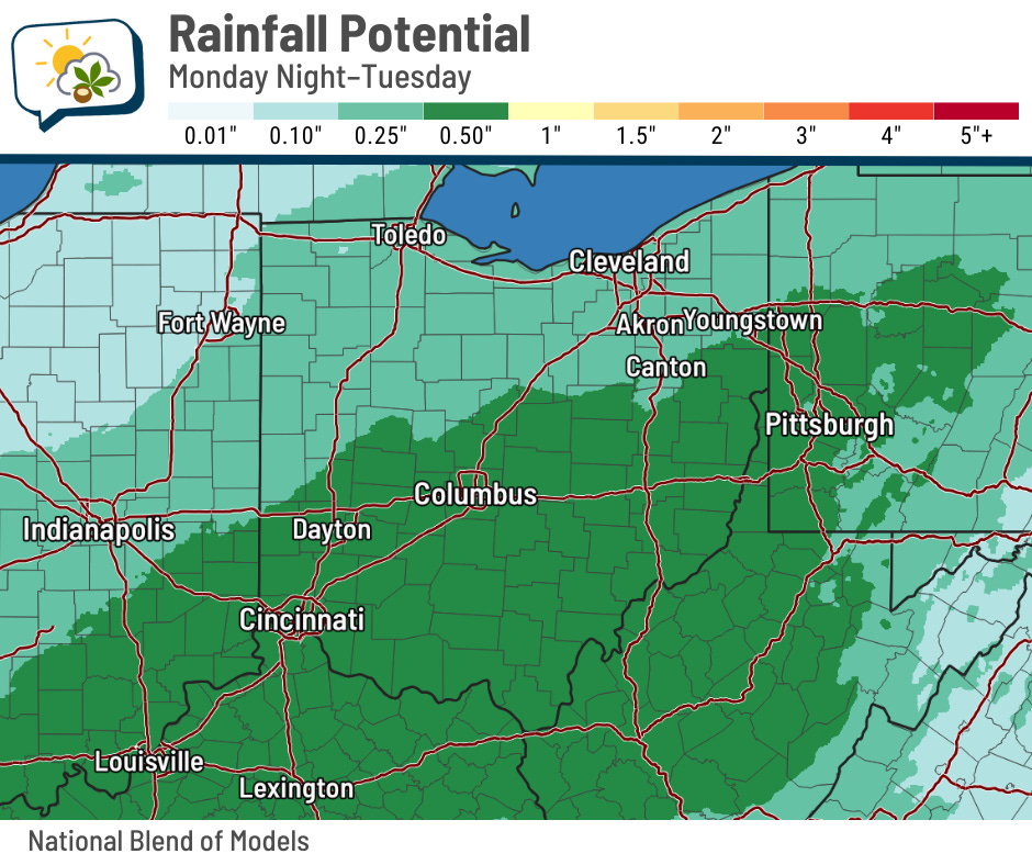
That weather system is in the Plains and ejects into our region tonight into tomorrow. It looks like showers should arrive after midnight and continue into Tuesday, with the highest chance in the morning.
Rainfall amounts could top a half-inch as the slug of moisture comes up from the southwest.
Quick on the heels of that system is another one swinging in from Canada on Wednesday. That brings the off-chance of a passing shower, but the much bigger impact will be on our temperatures…
🍗 Cold turkey
We’re in for a very noticeable temperature drop this week.

Even with clouds and showers tomorrow, highs will still reach to about 10 degrees above average. A cold front then blasts through early Wednesday, giving us a morning high around 50 before readings fall most of the day.
Thanksgiving’s going to be chilly. That high of 35 is already enough to get your attention, but blustery winds will keep wind chills in the 20s.

Temperatures moderate again early next week.
📊 Today’s almanac
Normal low/high: 33 / 49
Record low/high: 8 (1950) / 68 (1931)
Sunrise/set: 7:27 a.m. / 5:09 p.m.
✈️ Thanksgiving travel preview
The busy travel time is almost upon us… here’s a loop of the forecast radar from the main American model from Wednesday morning through Saturday evening.

The system that comes through here tomorrow will already be exiting the East Coast Wednesday, but it’ll have plenty of wind behind it. Thanksgiving itself doesn’t bring much for rain or snow across most of the country, and Friday doesn’t have a lot happening quite yet, either. However, more active weather takes shape on Saturday.
Here’s the nuts-and-bolts breakdown:
-
Wednesday: Spots of showers in New York and parts of the East Coast. Very windy across much of the Great Lakes region.
-
Thanksgiving: Lake-effect snow off Lake Erie and Ontario. Rain develops in the Pacific Northwest.
-
Friday: Bands of lake-effect snow continue in the same areas. Some snow spreads into the Northern Rockies and Northern Plains.
-
Saturday: Areas of snow in the Northern Plains and parts of the Upper Midwest, possibly extending as far east as Indiana/Michigan/Ohio late. Rain/storms develop from Missouri/Illinois southward toward Texas.
As always, timing and placement of the weather action will probably shift somewhat. If you’re traveling outside the area, check in on the forecast on the web or on mobile.
💬 Follow me on social
🌭 For the weather weenies
-
Alaska Native villages have few options and little US help as climate change devours their land (Associated Press)
-
Satellite composite of every Category 4 and 5 Atlantic hurricane since 2020 (CIRA/Bluesky)