📢 I started this newsletter back in June to give me a little something to do while unemployed. My position as a federal contractor supporting NOAA’s Weather Program Office was eliminated through a complicated set of circumstances, but I’m happy to report that, as of today, I am no longer unemployed. I’ll be… in the same role as before as a federal contractor supporting NOAA’s Weather Program Office. 😆
What does that mean for this newsletter? I’m not sure yet! I intend to continue it because I enjoy doing it, but obviously having a Real Job affects things. We’ll see how this week goes; if I need to adjust the posting cadence, I’ll wait until next week at the earliest.
Okay, without further delay…
The 614cast
Today’s tl;dr
🌥️ Increasing clouds, high in the mid-30s.

Forecast highlights
❄️ Quick-moving system brings accumulating snow
The powerhouse storm system that dumped heavy snow on the Upper Midwest the other day did very little here. But another system gliding up the East Coast will throw snow our way tonight into early tomorrow.
Here’s the forecast radar from one of the high-resolution models at midnight tonight, 7 a.m. tomorrow, and 10 a.m. tomorrow.
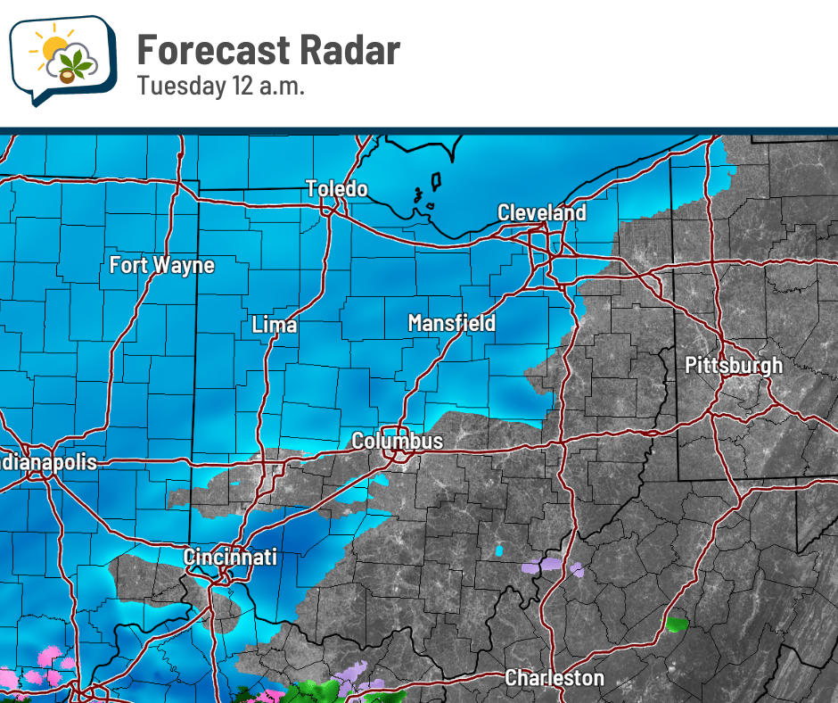
It looks like the bulk of the snow will happen from about midnight through 8 a.m., quickly heading out thereafter. Snow will probably be falling during the morning commute; even if it’s tapering off, there will have been several hours of snow beforehand. If you have a commute tomorrow morning, plan on it taking extra time.
As far as how much snow to expect, 2–3” looks quite likely with the potential for 3–4”. The National Weather Service forecast as of yesterday afternoon puts us in that latter category. Fortunately, we will not have blustery winds making this more troublesome.
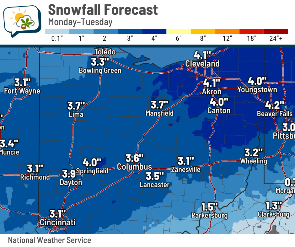
With temperatures rising a little above freezing in the afternoon, some of that will melt/compact.
🧣 Cold week ahead
The average high the first week of December is in the mid-40s. We’ll be nowhere near that.
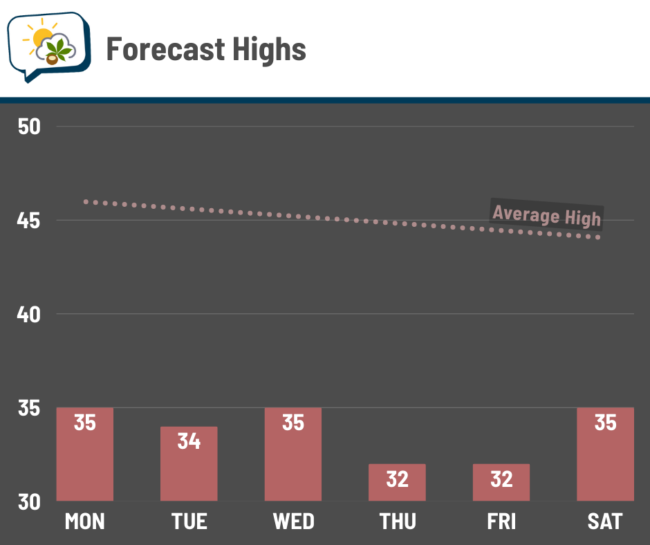
Highs will be stuck in the lower to middle 30s all week, about 10 degrees short of normal. While winds won’t be as gusty as some recent days, it doesn’t take much to make it feel extra brisk. I think that’ll especially be the case Thursday into Friday morning.
📊 Today’s almanac
Normal low/high: 31 / 46
Record low/high: 7 (1964) / 67 (1970)
Sunrise/set: 7:34 a.m. / 5:07 p.m.
🎄 December’s averages
Here’s how things shake out in December.
🌡️ Normal high and low temperature
-
December 1: 46 / 31
-
December 31: 38 / 24
🌧️ Precipitation
-
Rain + melted snow: 3.13”
-
Snow: 5.1”
🌇 Sunrise and sunset
-
December 1: 7:34 a.m. / 5:07 p.m. (9 hours, 32 minutes of daylight)
-
December 31: 7:53 a.m. / 5:16 p.m. (9 hours, 23 minutes of daylight)
📊 Average number of days with highs…
-
60 or warmer: 2
-
50s: 6
-
40s: 9
-
30s: 10
-
Cooler than 30: 4
🌭 For the weather weenies
-
Lake Erie’s displaced water uncovers shipwreck likely from 1800s, historians say (Detroit Free Press)
-
As the 2025 Atlantic hurricane season ends, the future of forecasting is AI (NPR)