The 614cast
Today’s tl;dr
🌥️ Snow ends early, mostly cloudy, high in the mid-30s.

Forecast highlights
🌨️ Another (small) snow chance in a couple days
The latest snowmaker quickly heads out this morning, which means the evening drive will be much better than the morning. Well, at least from a weather standpoint; I can’t make any promises about the drivers.

A little area of high pressure scoots through heading into tomorrow, giving us a short-lived round of quiet weather before the next weather system arrives.
That one will come through with little fanfare in the snow department. I expect little, if any, accumulation Wednesday night into early Thursday… chances of snow aren’t that great.
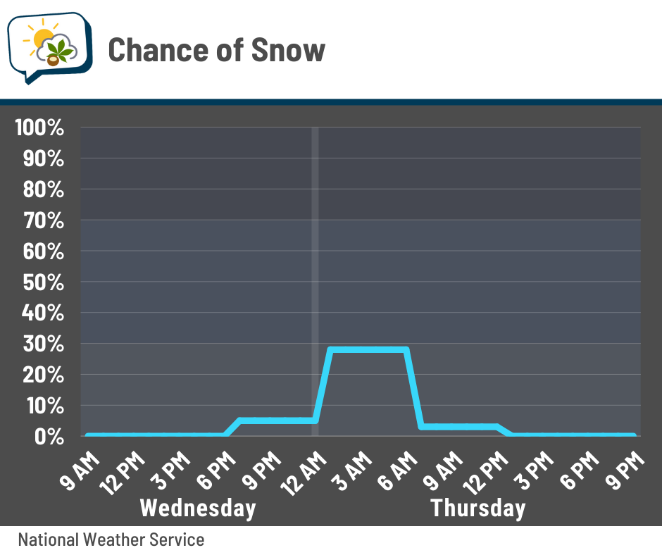
If we do have anything, it’ll be a low-impact event. However, the cold front with that system will make itself known in another way…
🧤 Coldest of the season so far
We’ll get a couple more days in the mid-30s before a quick shot of cold air. Temperatures behind that cold front on Thursday will probably be fairly steady most of the day and may fall a bit at times.
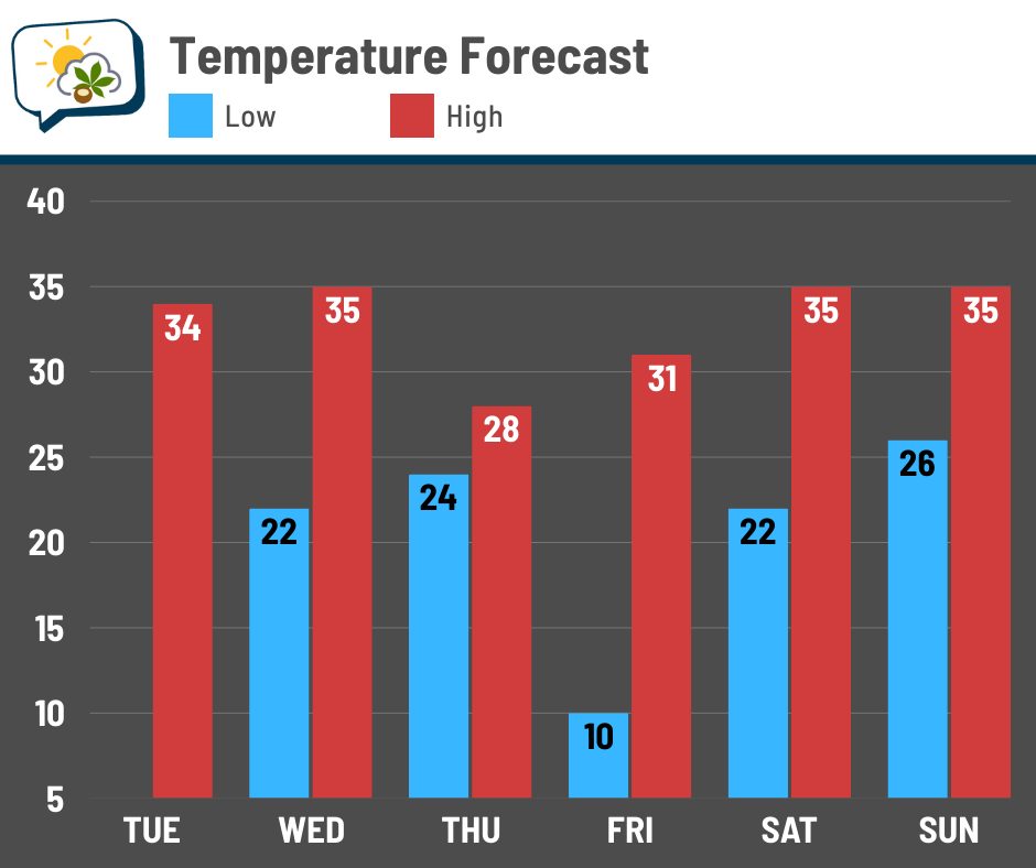
And then the bottom drops out Friday morning. If we fall all the way to 10, it’ll be the coldest morning since February 18. (Sure beats what’s happening back in my ol’ Iowa stomping grounds… -10 or so Thursday morning, easily beating record lows. And they just got a foot of snow. Yikes.)
📊 Today’s almanac
Normal low/high: 31 / 46
Record low/high: 1 (1886) / 72 (1982)
Sunrise/set: 7:35 a.m. / 5:07 p.m.
⏪ November & climatological fall review
Let’s start off with November, which was fairly run-of-the-mill, on average:
-
Average high: 51.6° (0.7° below normal)
-
Average low: 34.1° (0.9° below normal)
-
Average temperature: 42.9° (0.8° below normal)
-
Precipitation: 2.32” (0.47” below normal)
-
Snowfall: 1.8” (0.6” above normal)
The superlatives:
-
Warmest high: 67° on the 5th
-
Coolest high: 33° on the 10th
-
Warmest low: 49° on the 15th
-
Coolest low: 19° on the 29th
-
Rainiest: 0.70” on the 25th
-
Snowiest: 1.3” on the 10th
And a couple other numbers…
-
Coldest wind chill: 11° on the 10th
-
Highest wind gust: 43 mph on the 5th and 26th
And now climatological fall, which ran from September 1–November 30:
-
Average high: 67.3° (2.1° above normal)
-
Average low: 45.9° (0.5° above normal)
-
Average temperature: 56.6° (1.3° above normal)
-
Precipitation: 8.16” (0.67” below normal)
-
Snowfall: 1.8” (0.4” above normal)
The superlatives:
-
Warmest high: 89° on 9/15, 9/19, 9/20
-
Coolest high: 33° on 11/10
-
Warmest low: 68° on 9/21
-
Coolest low: 19° on 11/29
-
Rainiest: 1.84” on 10/7
-
Snowiest: 1.3” on 11/10
Plus…
-
Last 70-degree high: October 19 (tied for 9th earliest date on record)
-
No fall 90s: 3rd time in the past 10 years, first since 2022
🌭 For the weather weenies
-
How to properly measure snow (National Weather Service)
-
Interactive snowfall report map (National Weather Service)