Columbus managed to hit 48 on Wednesday thanks to bonus sunshine. It was the first day in the 40s in a week, and the warmest day in three weeks — yes, the day before Thanksgiving.
The 614cast
Thursday’s tl;dr
🌥️ Increasing clouds with rain developing late. Windy with a high in the lower 50s.

Forecast highlights
☔ A period of wet, but not too wintry
A sign of the warmer weather: We have rain coming.
Most of Thursday will be dry. A few showers could develop in the afternoon, but it really looks like the bulk of the rain will be in the evening through early overnight hours — say, roughly 6 p.m. to midnight.
Here’s the timing from one high-resolution model. It brings the line of heaviest rain through around 8 p.m., which might be a bit earlier than reality. Regardless, it’ll come well after the evening commute.
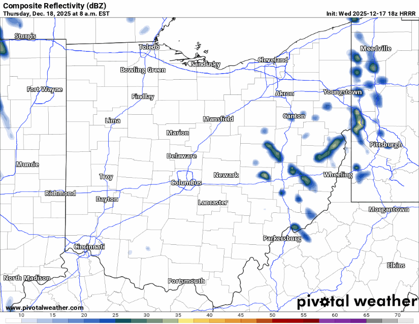
I wouldn’t be surprised if there’s some thunder along with that line.
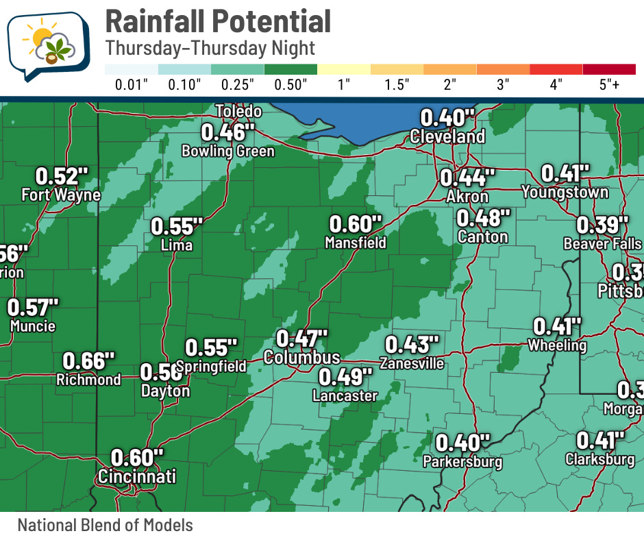
Rainfall amounts look to be roughly around a half-inch or a bit higher. This will be an efficient little rain-maker for mid-December.
The rain will probably change to a little wet snow Thursday night before moisture mostly shuts down. Scattered nuisance snowflakes remain possible into Friday, but they won’t be an issue.
However, be mindful of patchy slick spots for the Friday morning commute if there’s leftover wet pavement that the wind hasn’t dried up. Temperatures will fall into the 20s, and bridges/overpasses will be most susceptible to any refreezing.
🎢 Up, then down, then moderating again
The idea of hitting 50 seems so strange, even after the milder weather on Wednesday. CMH last reached the 50s the day before Thanksgiving (it was 56 that day).
Don’t get used to 50s, though, as we have a sharp drop for Friday.
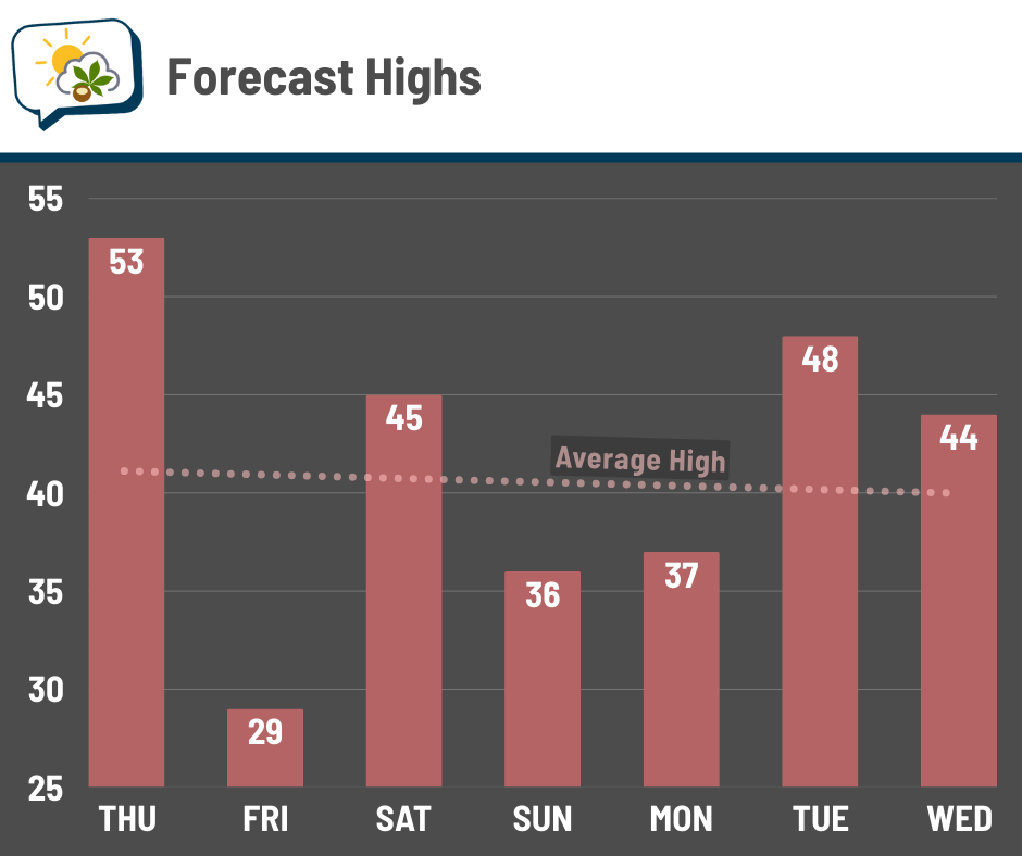
You’ll notice we recover nicely, with readings hanging out close to or above average this weekend into next week.
I would be remiss if I didn’t mention the wind, though. That breeze will cut into what would otherwise feel like a mild day on Thursday, and it’ll make Friday have an extra chill.
We’ll probably have gusts peaking around 30 mph, while sustained winds blow around 10–20 mph. Holiday inflatables in the yard should probably be kept turned off the next couple of days…
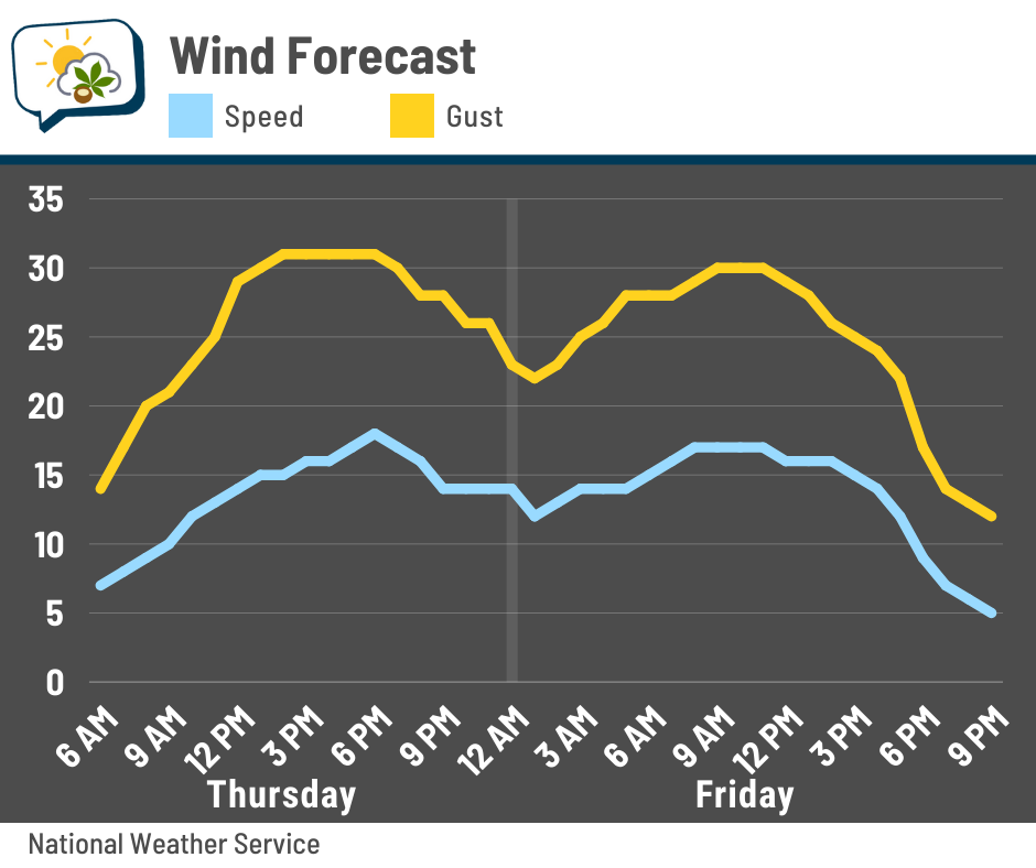
That’ll keep wind chills in the middle to upper teens for most of Friday.
📊 Thursday’s almanac
Normal low/high: 27 / 41
Record low/high: -7 (1989) / 63 (1967)
Sunrise/set: 7:48 a.m. / 5:08 p.m.
🎅 Dreaming of a white Christmas
Will central Ohio have a white Christmas this year?

We already melted most of the snow, and the upcoming rain and mild temperatures will take care of the rest. I don’t see any promising sign of it being replenished before next Thursday.
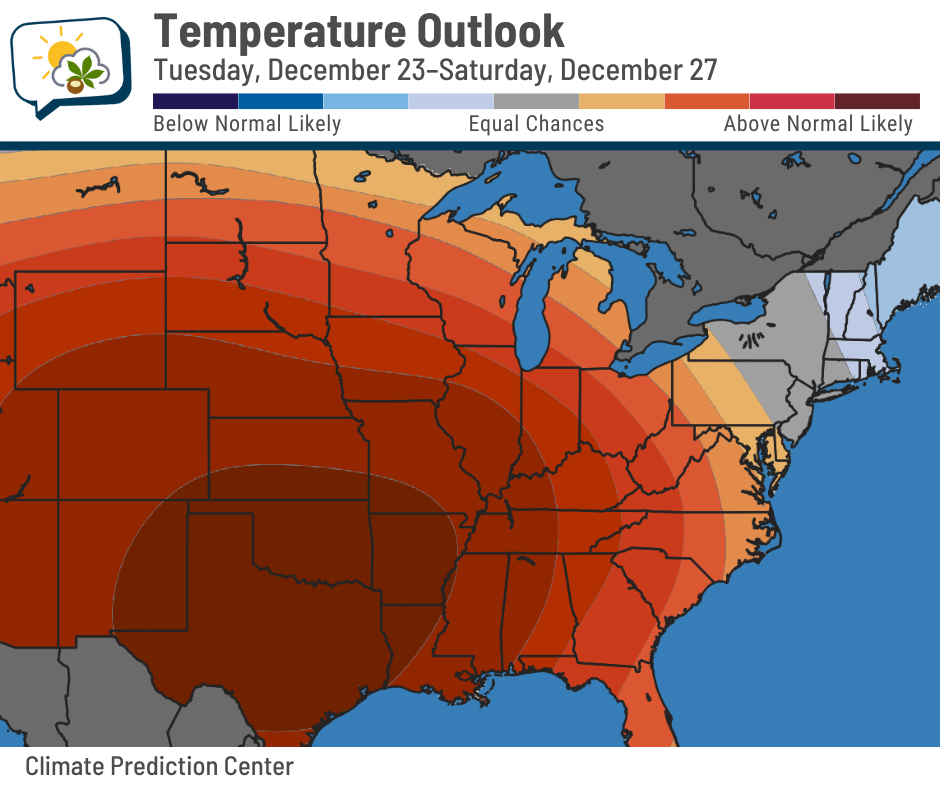
In fact, most days coming up feature above-freezing highs, including multiple 40s next week. The Climate Prediction Center’s temperature outlook for next week has us in pretty good odds of above-average temperatures, overall.
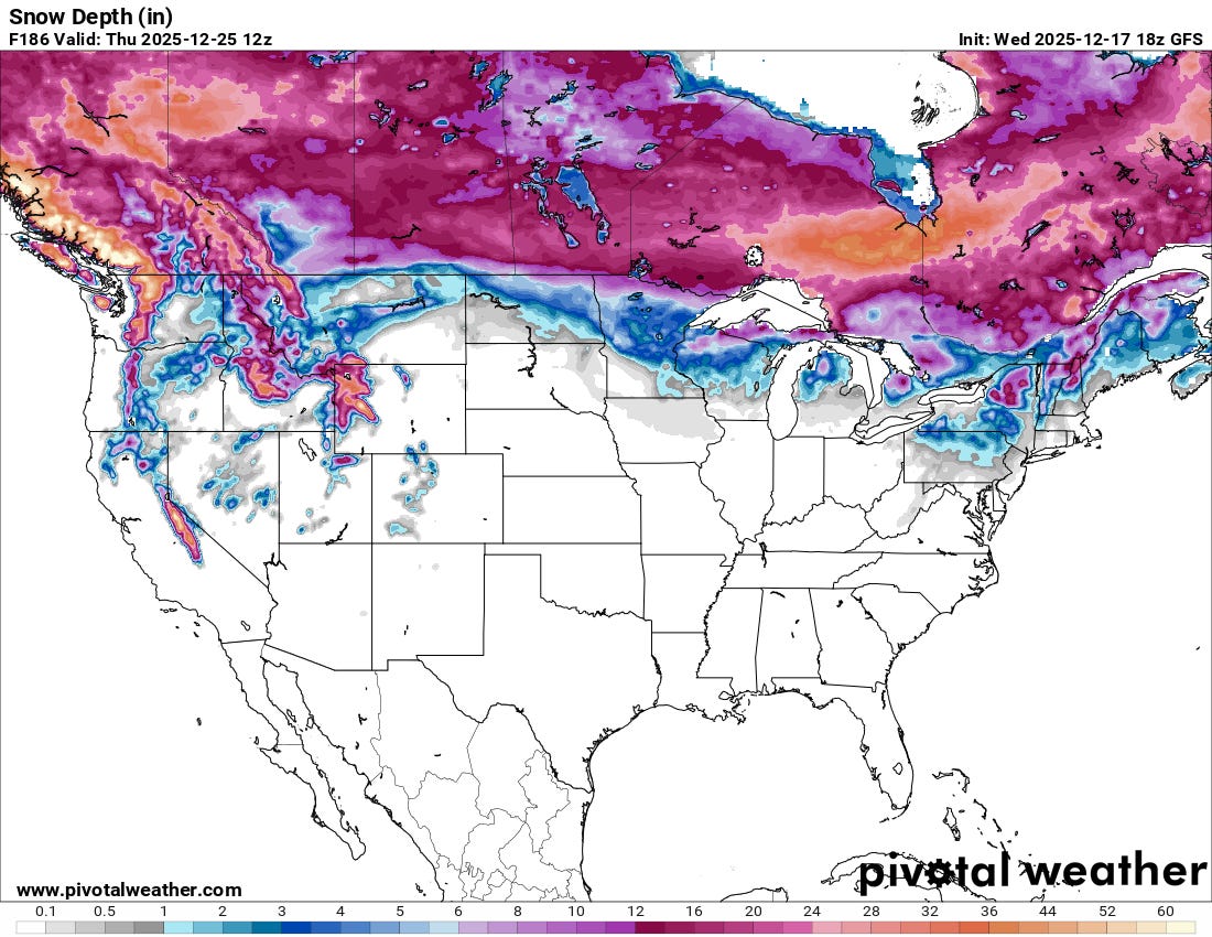
Only the places you might expect have a good shot at having snow on the ground in a week. Here’s the forecast snow depth from the main American forecast model; the European model is similar.
The past two years didn’t have any snow on the ground on Christmas… although 2023 would have been especially difficult since the high was 62. 😉 2022 had a 4” snow depth, tied for second deepest on record since 1948.
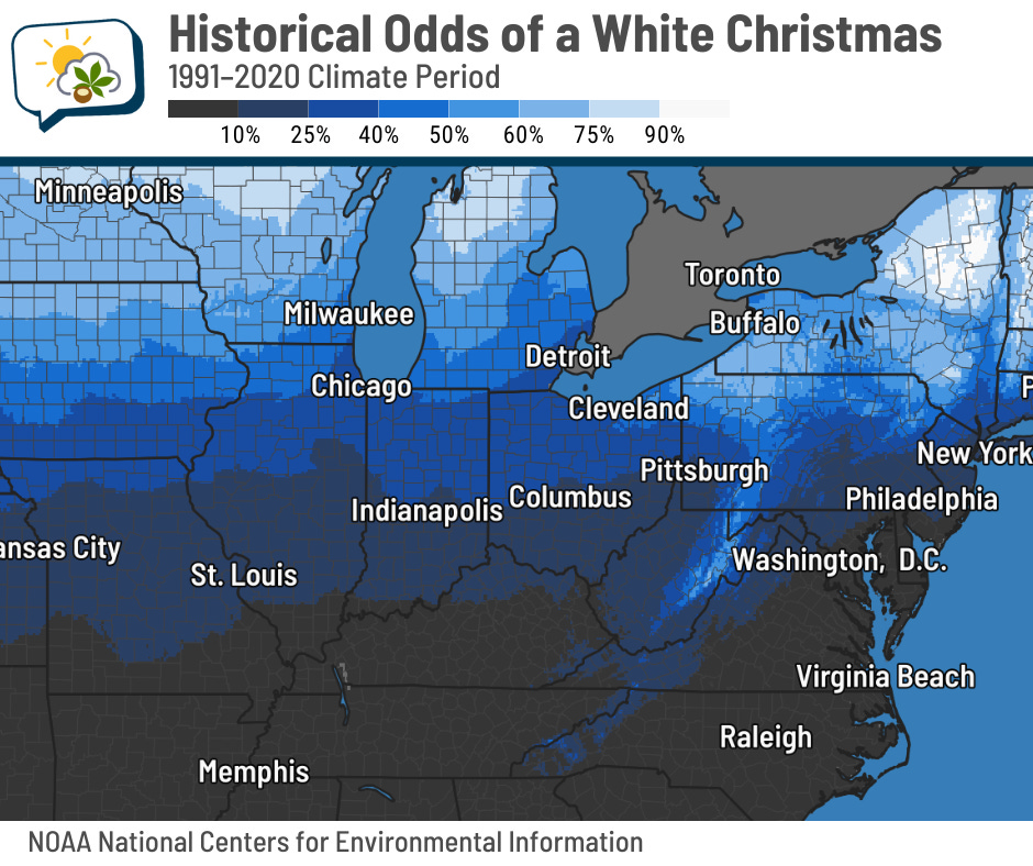
In any given year, climatology says central Ohio has about a 25% chance of a white Christmas — at least one inch of snow on the ground in the morning.
You can play around with an interactive map of this data here.
🌭 For the weather weenies
-
NOAA deploys new generation of AI-driven global weather models (NOAA)
-
Dr. Zack Labe on climate risks, impacts, and communication (Science Talk/YouTube)