For those reading this on Sunday, a line of storms is possible Sunday night along the cold front. It looks like that’ll happen somewhere between about 10 p.m. and midnight. There’s a low-end chance of strong to severe gusts with that.
⚠️ A wind advisory is in effect from 8 p.m. Sunday evening to 6 p.m. Monday evening.
The 614cast
Monday’s tl;dr
💨 Very windy. Cloudy with flurries possible. Steady temperatures in the upper 20s.

Forecast highlights
⬇️ Back into the chill
Monday’s high, probably around 60, will happen near midnight and won’t be at all reflective of what we experience during the day.
By the time most of us get going for the day, readings will be around 30 and should drop a little further before leveling out in the upper 20s. The wind will make it feel even colder.
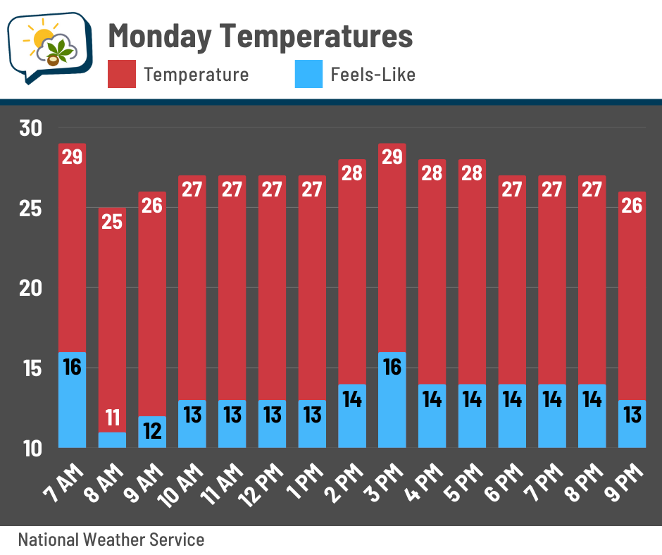
Yeahhhh that’s a sharp drop from Sunday’s 68°, which tied the record set in 1984.
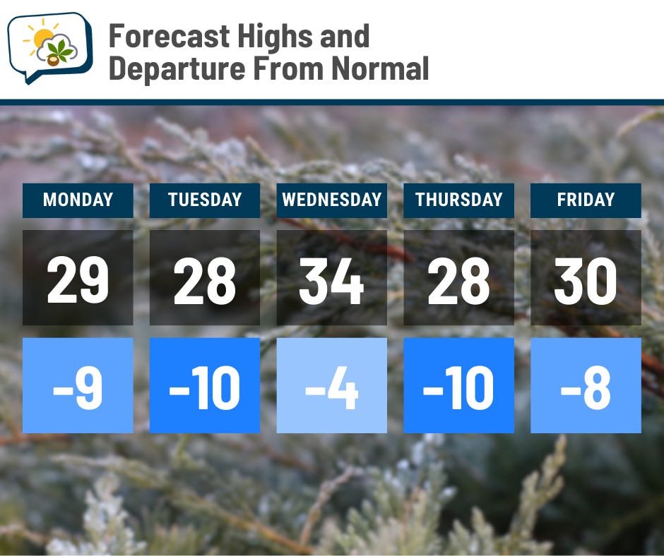
This week features below-average temperatures, with a couple of days probably stuck in the upper 20s.
🌬️ Windy to start the week
Winds pick up ahead of the Sunday night cold front, and boy will they be up there straight into Monday. Sustained winds will be around 20 mph, and gusts should top 40 mph from time to time.
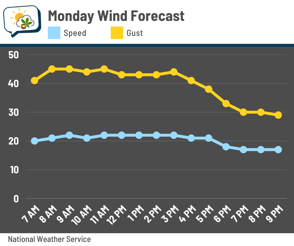
If it’s your garbage/recycling day… well, you might lose some of the contents of your bins. If you have extra boxes and such that you’re planning to set next to the bins, you might want to consider holding onto them for another week so they don’t blow away and litter the neighborhood. Or the next neighborhood over, for that matter. 😅 Same goes for the inflatables! Have those turned off or else you might have some issues.
Tuesday won’t be as windy, but with gusts still around 20–25 mph, it’ll still be quite brisk.
🌨️ Occasional snowflake chances
Persistent troughing over the eastern U.S. and Canada this upcoming week keeps us not just chilly, but sends sends occasional weak disturbances sliding through.
Timing them in the northwest flow is not exactly straightforward, but my best estimate now is maybe some flurries Monday in the wake of the current system, Tuesday night, and Wednesday–Wednesday night.
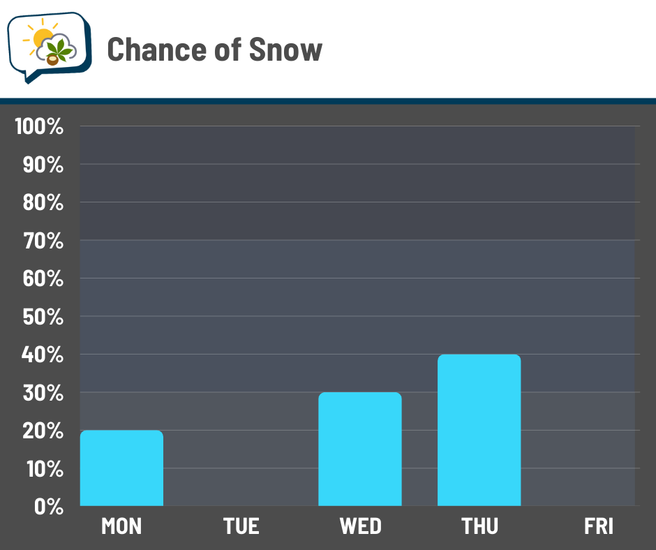
Yes, snow is possible for New Year’s Eve. However, it appears amounts should be light, if we have anything.
From Monday morning through Thursday morning, here’s the National Blend of Models’ chances of getting at least an inch of snow.
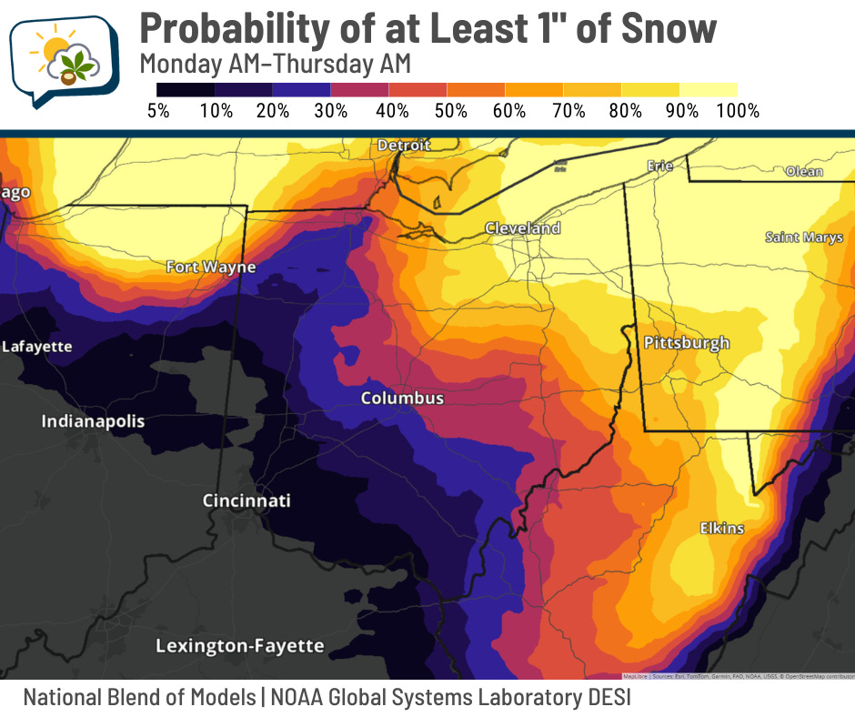
For the time being, odds greatly favor north of us. We’re only in about one-in-three odds. Even so, if you do have plans for Wednesday night, keep up with the forecast just in case things shift toward better odds of some slick roads.
📊 Monday’s almanac
Normal low/high: 25 / 38
Record low/high: -10 (1880) / 67 (1889)
Sunrise/set: 7:53 a.m. / 5:15 p.m.
❄️ Let’s talk blizzards
No, not one of these, sadly.

My wife’s family in northern Iowa is currently in their second blizzard warning of the season. Meanwhile, the Wilmington National Weather Service office (which covers the Columbus area) hasn’t issued a blizzard warning in over a dozen years.
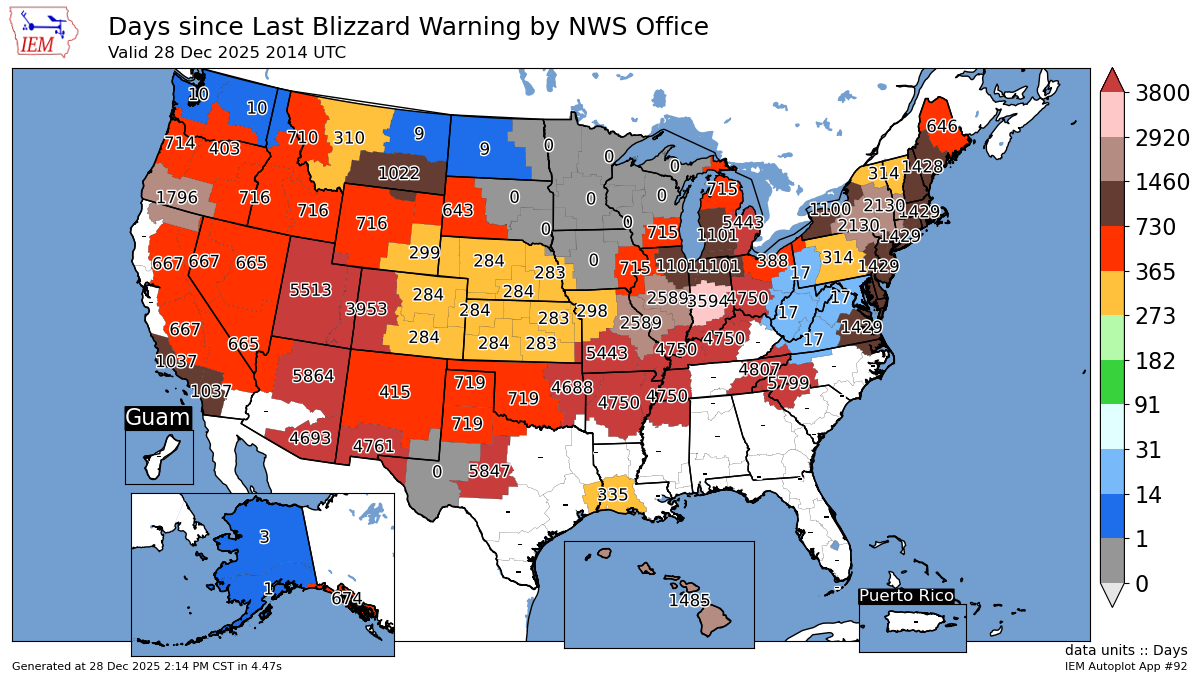
The last one was 4,750 days ago as of Sunday. It was just west of Columbus proper:

The last one to include Franklin County was in 2008.
Going back to January 1, 2006, the Wilmington NWS office has issued just three blizzard warnings. Meanwhile, the Des Moines office has issued 38, and Grand Forks has issued 90! You can see a clear geographical pattern on this map.

Blizzards require not just falling or already-fallen snow, but strong winds (35 mph or higher), reducing visibility to a quarter-mile or less. Those conditions are most common in the Northern Plains, adjacent areas of the Upper Midwest, and the Rocky Mountains.
🌭 For the weather weenies
-
Warmest Christmas on record for the contiguous U.S. (Brian Brettschneider/Bluesky)
-
The moon and sun figure big in the new year’s lineup of cosmic wonders (Associated Press)
-
Google Flood Hub (Google) — h/t to Matt Lanza