It’s another Tuesday night special this week, since I’ll be doing family holiday stuff later tomorrow.
Also, I put together a 2025 Wrapped: Columbus Weather Edition over on my Insta:
The 614cast
Wednesday’s tl;dr
🌨️ Mostly cloudy with light snow late. Turning windy, high in the lower 30s. New Year’s Eve temperatures fall into the mid-20s with wind chills in the mid-teens.

Forecast highlights
❄️ Two bouts of light snow
One batch of light snow comes through overnight Tuesday night and should be out by daybreak Wednesday. It’ll be followed by another round of snow New Year’s Eve.
Between the two of them, we could pick up around an inch or two in total. Here’s the National Weather Service forecast…
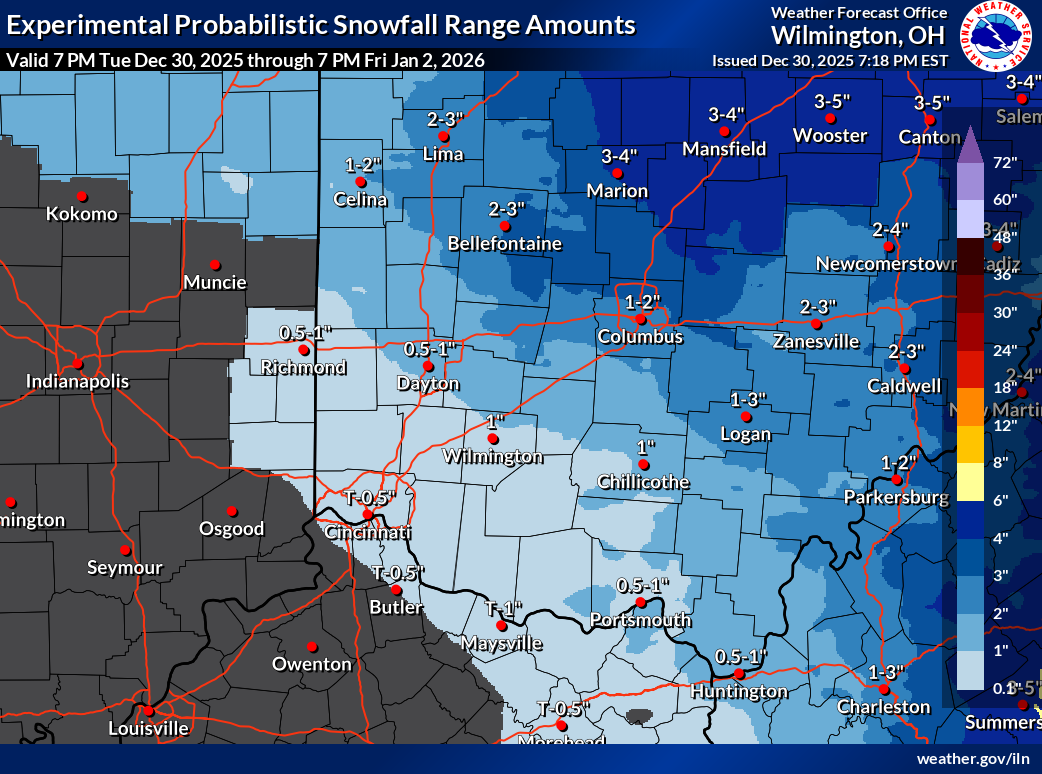
… and the National Blend of Models.
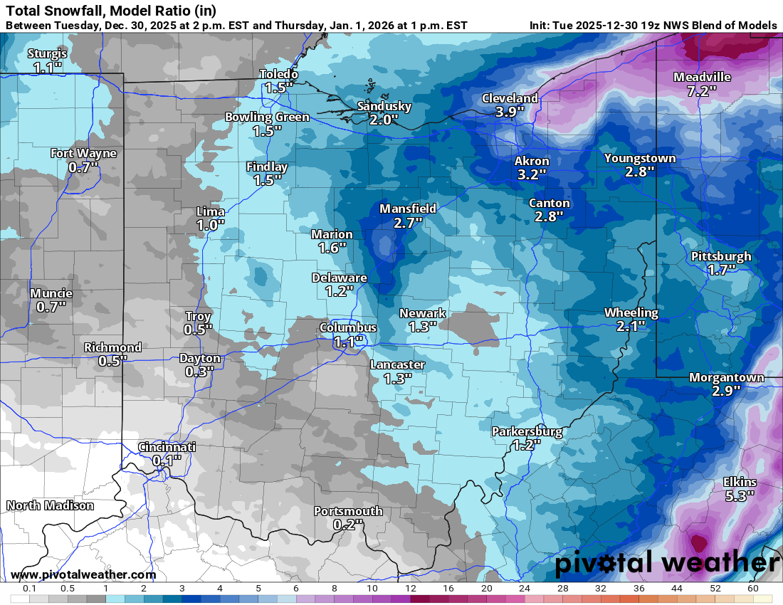
Higher amounts are definitely favored to our north. It’ll be significantly lake-enhanced up in far northeastern Ohio.
If you’re working Wednesday morning, assume there’ll be some leftover slick spots, even though snowfall amounts will be minor.
And for those going out New Year’s Eve, it looks like the primary window for snow should be roughly 6 p.m. to 1 a.m. We’ll have wind gusts over 20 mph accompanying the snow showers, so visibility may be reduced at times — in addition to roads probably having some snow on them.
🧣 Staying chilly into the new year
Not much to say here… things stay chilly, but not unreasonably so, for a while. Highs should stay below average until perhaps Monday.
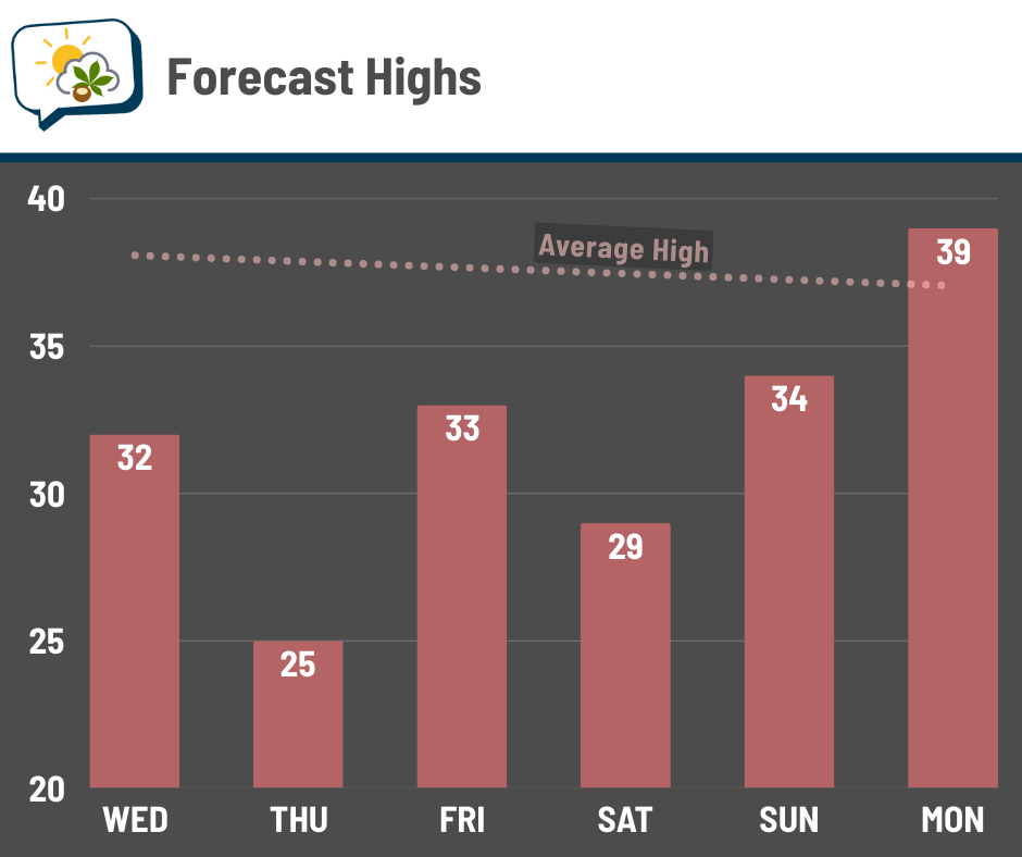
The primary forecast guidance does suggest that we’ll continue moderating next week. No, don’t hope for 50s and 60s again. 😜 But 40s are certainly a possibility. We’ll see if that trend holds.
📊 Wednesday’s almanac
Normal low/high: 24 / 38
Record low/high: -5 (1976) / 68 (1951)
Sunrise/set: 7:53 a.m. / 5:16 p.m.
🍾 New Year’s Day weather history
-
Warmest high: 67° (1952)
-
Coldest high: 8° (1928)
-
Coldest low: -6° (1968)
-
Wettest: 1.34” (2022)
-
Snowiest: 5.2” (1964)
🌭 For the weather weenies
-
Lake Erie sloshed like a bathtub Monday; here’s why this seiche happened (The Weather Channel)