I think I heard robins while walking the dog Wednesday afternoon. You know what that means for spring?
Nothing. It means nothing. 😁 Not all robins migrate. This is one of my long-standing rants that my college weatherfriends, without fail, bring up every year in the form of telling me about their robin sightings.
The 614cast
Thursday’s tl;dr
🌥️ Increasing clouds, high in the mid-50s.
Forecast highlights
🏆 Warm enough to challenge records
Temperatures will be way above normal the next few days.
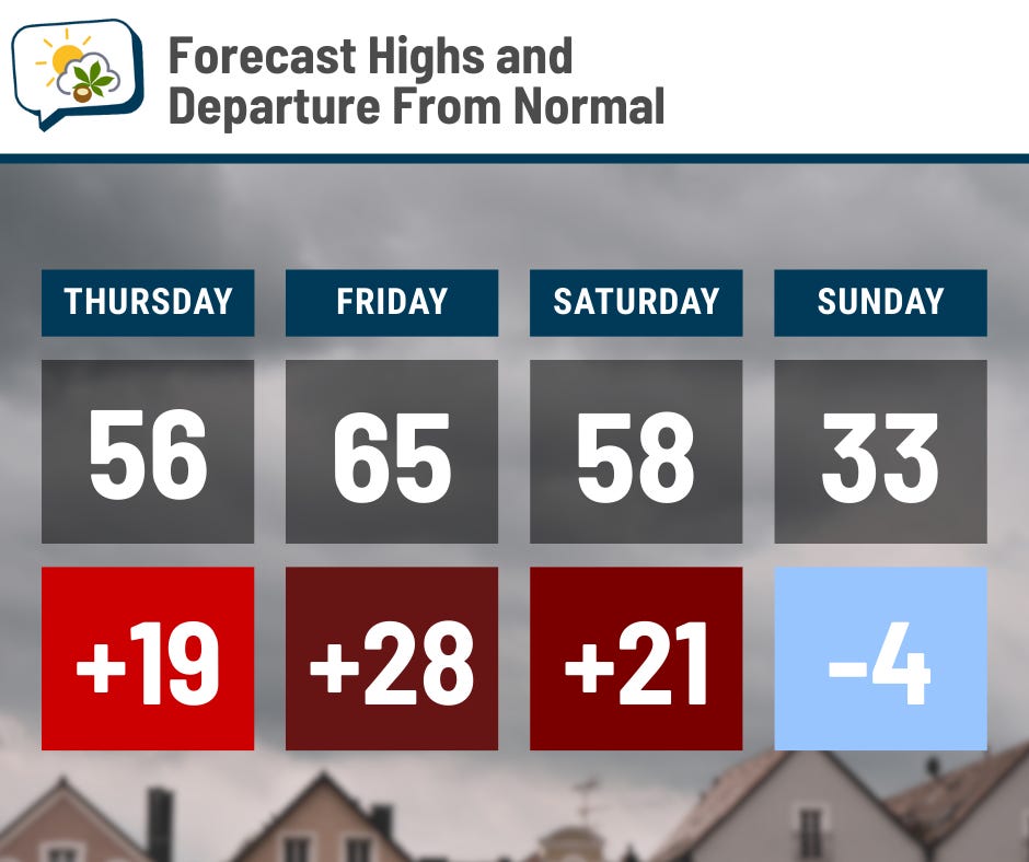
While Thursday’s record high of 68° is safe, it looks like Friday’s record high of 62° will fall. The big cold front is coming later than previous expected, so Saturday will also be quite mild. The record high that day is now also in jeopardy; it’s the lowest record high of the month at 59°.
Friday morning will also be very mild, starting in the lower 50s. That’s well above the average high for the day, of course, and ought to set a new record warm low. The current record is 50°.
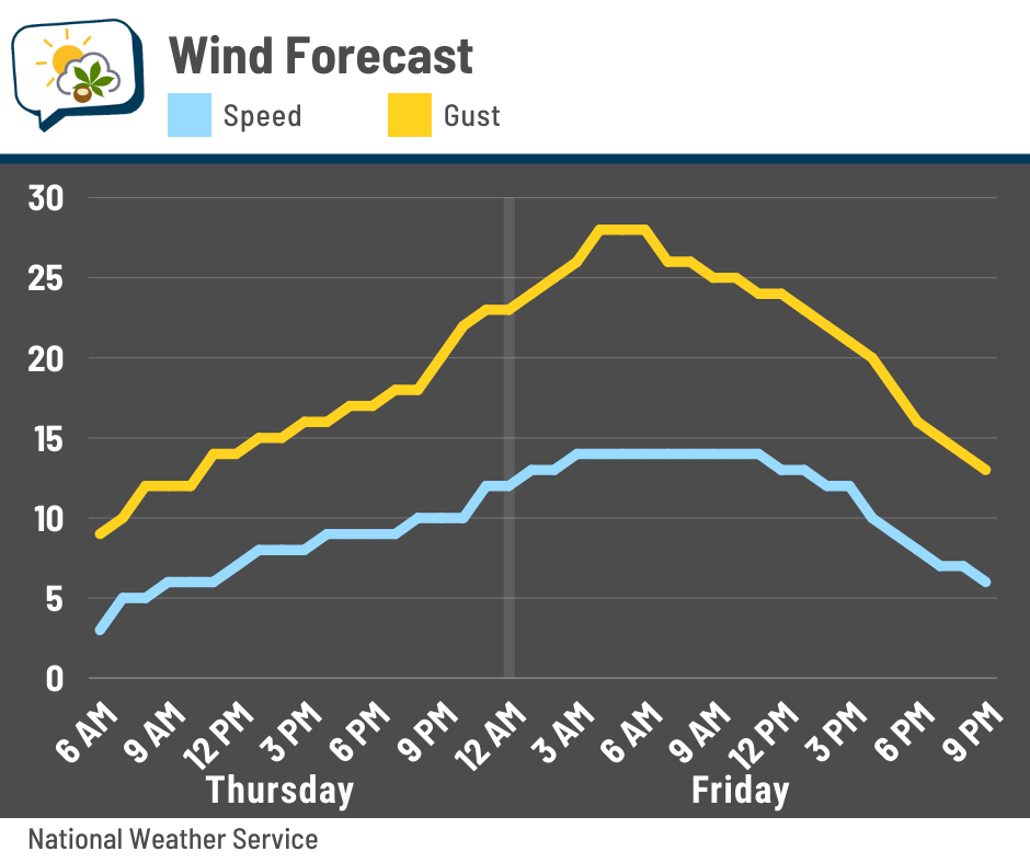
Dew points rise well into the 50s on Friday, which is humid for early January.
All this is possible because of southerly winds, which gradually pick up on Thursday. They’ll be fairly breezy Thursday night into Friday, with the gustiest winds coming late Thursday night into early Friday morning.
🌧️ Periods of rain to end the week
Our next system is digging across the far southwestern U.S. as of Wednesday evening.
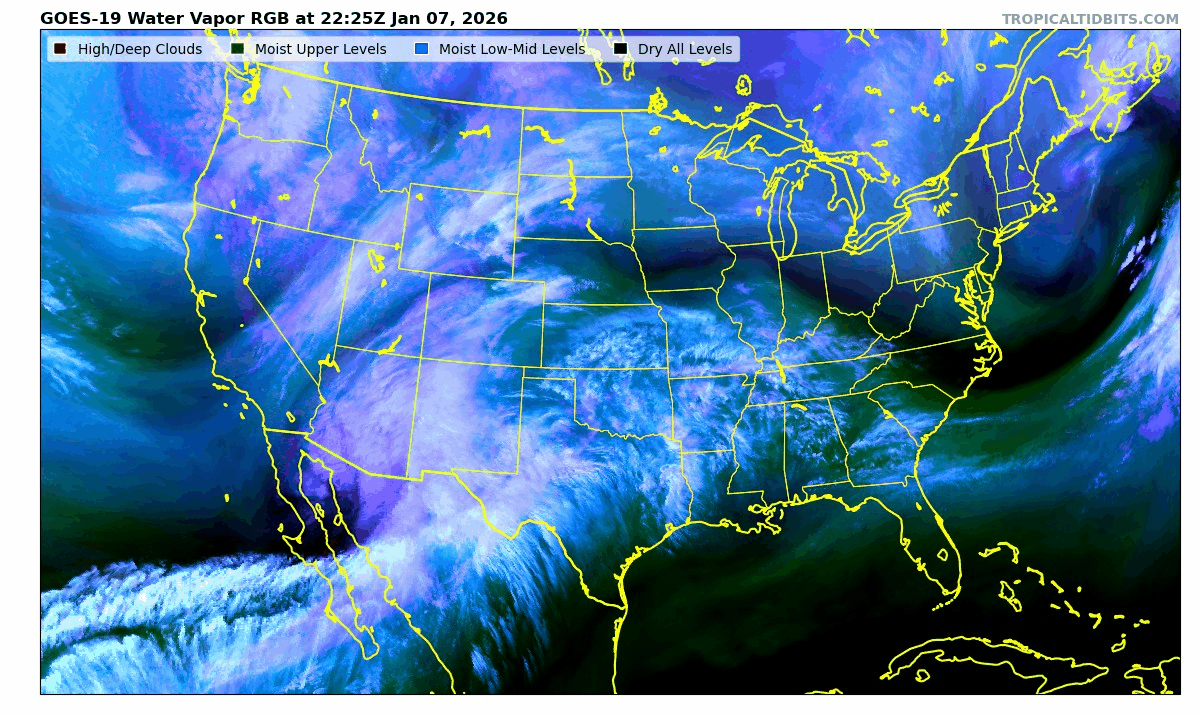
It’ll hook to the Midwest and Great Lakes Thursday into Thursday night and brings us our first round of shower chances. A separate, larger system comes in from the north afterward, keeping us in rain chances into Saturday before dumping in colder air.
Showers will be intermittent Thursday night (maybe as early as the evening, but probably not) through Saturday. It looks like the best chances should be Thursday night through midday Friday, then again early Saturday through the early afternoon. Timing, may shift a bit, but that’s where things are currently lining up.
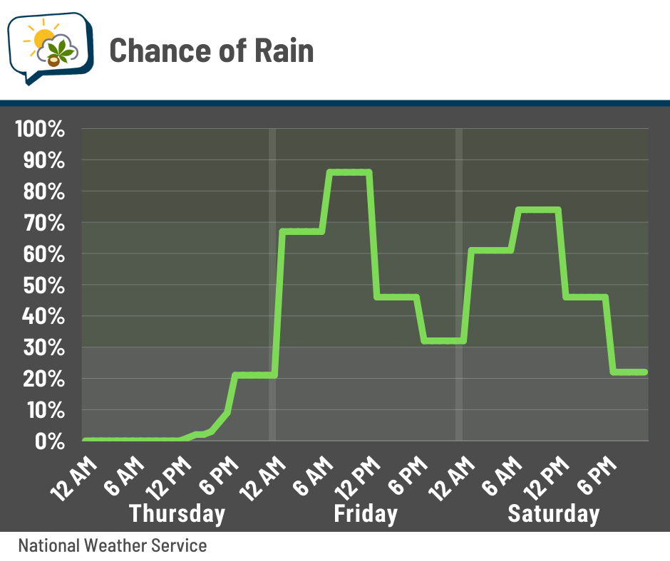
There could even be some thunder to accompany the rain.
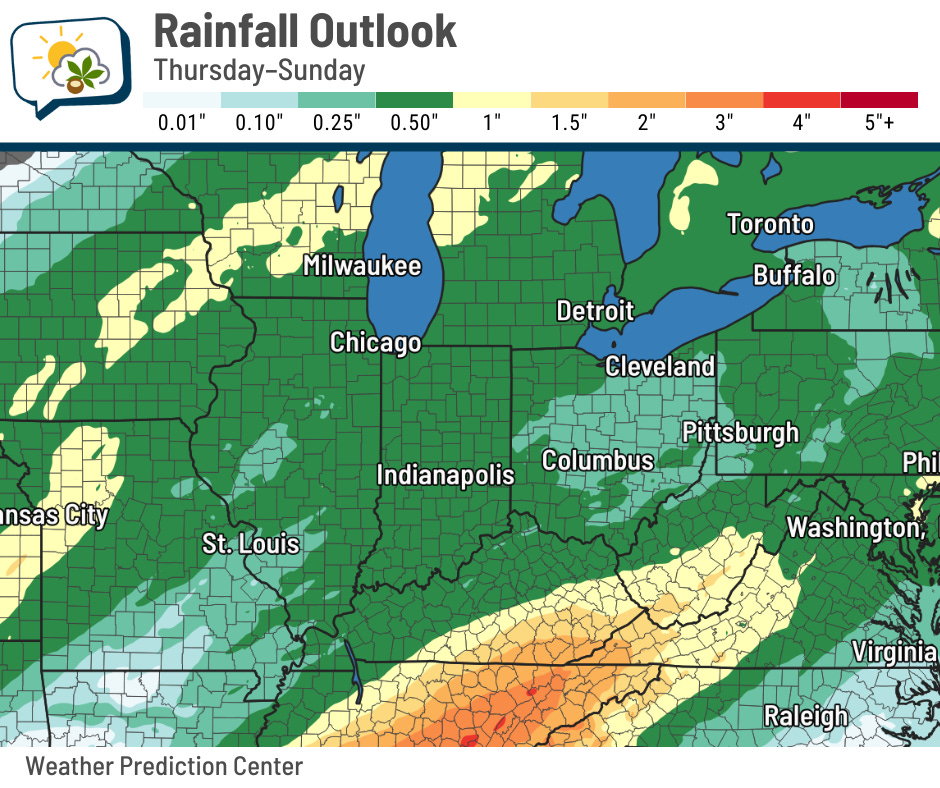
The highest rainfall will lie well to our northwest and southeast. It doesn’t look like we’ll have any prolonged steady rain, so amounts will probably be near or less than a half-inch.
With all the moisture around, some of the forecast guidance is hinting at the potential for fog Saturday morning.
📊 Thursday’s almanac
Normal low/high: 23 / 37
Record low/high: -9 (1968) / 68 (2008)
Sunrise/set: 7:53 a.m. / 5:24 p.m.
☁️ Winter is cloudy, but not that cloudy
I subscribe to the Axios Columbus daily newsletter, and generally like the very digestible format of their news briefs. But as I’ve seen with the Columbus Dispatch, sometimes you should really tap a meteorologist if you’re going to talk about weather.
Wednesday’s newsletter included this assertion: “It’s not uncommon to go weeks at a time without a sunny day this time of year.”
I immediately perked up at that, because it did not pass my smell test. And because I’m a meteorologist, I knew right where to look.
Let’s look at the cloud amounts and levels in January 2025. Anywhere the column is entirely blue, that means a fully clear sky. Grays indicate partial cloudcover, while black is overcast.

Okay, we had multiple times of fully clear sky last January. Let’s try 2024.

Still no weeks-long gaps between clear sky. How about 2023?

Same.
… 2022?

By now, I imagine you’re sensing a theme — that no, we never go weeks without a sunny day, a far cry from the notion of it being “not uncommon” — so I’ll stop there.
Yes, wintertime is cloudier here, but we’re not unique.
I’ll discuss why this time of year is cloudier in a future newsletter.
🌭 For the weather weenies
-
Ohio Sea Grant releases 2025 report on harmful algal bloom research (The Crescent-News)
-
Snow and ice wreak havoc across Europe, causing deadly accidents and travel chaos (Associated Press)
-
Vaisala Xweather Annual Lightning Report 2025: U.S. lightning hits eight-year high (Vaisala Xweather)
-
The Blizzard of ‘96 in retrospect (National Weather Service Heritage)