The 614cast
Monday’s tl;dr
🌥️ Scattered light snow ends, then decreasing clouds. Blustery with a high near 20 early, then falling temperatures.

Forecast highlights
🐧 Brief arctic blast
Okay, I realize that having a penguin emoji next to a headline about an arctic blast doesn’t make sense because they don’t even live in the Arctic. But it’s my newsletter and I can use creative license as an excuse.
A cold front plows through the state Monday morning, and boy howdy does it mean business.
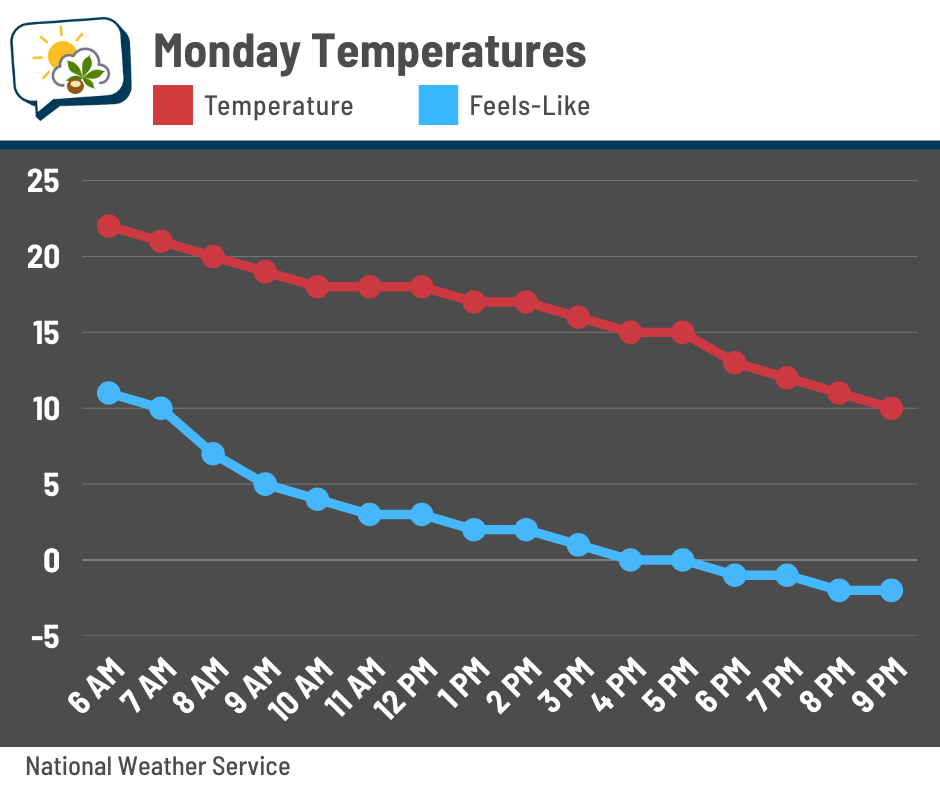
The warmest part of the day will be… *checks notes* …before sunrise. Temperatures steadily fall through the teens thereafter, and the wind chill will follow suit. They’ll dip below zero in the afternoon and stay there through about midday Tuesday.
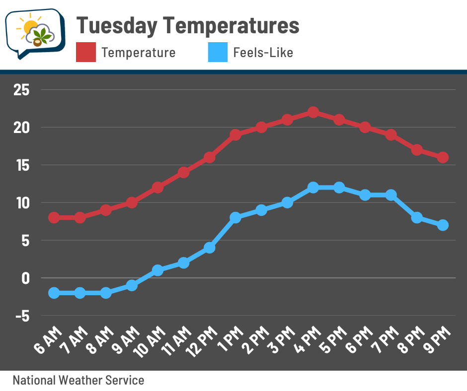
After a cold start in the single digits Tuesday morning (again, with wind chills at least a few degrees below zero), readings recover for the afternoon. Granted, highs in the lower 20s are still 15ish degrees below average, but it’s something, right?
These wind chills aren’t in “danger” territory where frostbite happens in, say, 15 or 20 minutes… but it’s still going to be quite unpleasant.
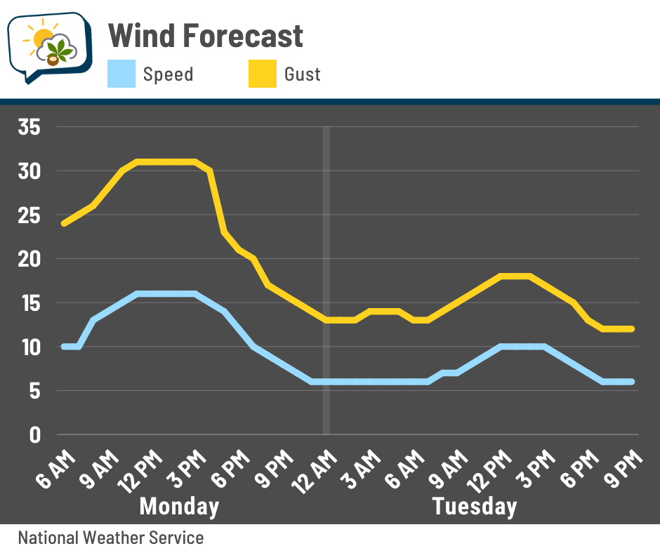
Monday will also be the windiest of the two days. Sustained winds should be around 15 mph for much of the day with gusts around 30 mph. It’s not going to be very nice, even with sun coming out in the afternoon.
Winds will be lower on Tuesday, but still brisk.
🌨️ Couple of minor snow chances
A weak disturbance brings scattered snow showers to central Ohio Sunday night into early Monday. With the cold temperatures, this will be a fluffy snow, and so it won’t take much to get some accumulation. Even so, amounts look minor… probably in the neighborhood of a half-inch or less. The better chance of approaching an inch will be north of Columbus.
Another Alberta clipper swings by in the Wednesday–Thursday period. This, too, looks like it’ll be mostly a scattered-and-light event.
I haven’t paid attention to see if there’s been chatter about a big ol’ blockbuster storm next weekend… if so, it’s awfully premature. The American model (the GFS) was showing something noteworthy on earlier runs, but has since backed off on doing much here. Guidance is showing something is possible somewhere in the eastern U.S. next weekend, but trying to get into specifics would be foolhardy at this juncture.
📊 Monday’s almanac
Normal low/high: 21 / 37
Record low/high: -22 (1994) / 67 (1907)
Sunrise/set: 7:49 a.m. / 5:35 p.m.
🥶 Coldest low on record
The record low for January 19 is -22°. That also happens to be the coldest temperature on record in Columbus.
It was part of a bitterly cold blast that encompassed much of the central and eastern U.S. for several days.
It was already cold several days beforehand, with two mornings dropping below zero. Then a winter storm dumped over 6” of snow in Columbus on the 17th, amplifying a secondary punch of bitterly cold air that surged in thereafter.
Here’s the weather map from the morning of January 19, 1994. A big ol’ high pressure is centered near Cincinnati.
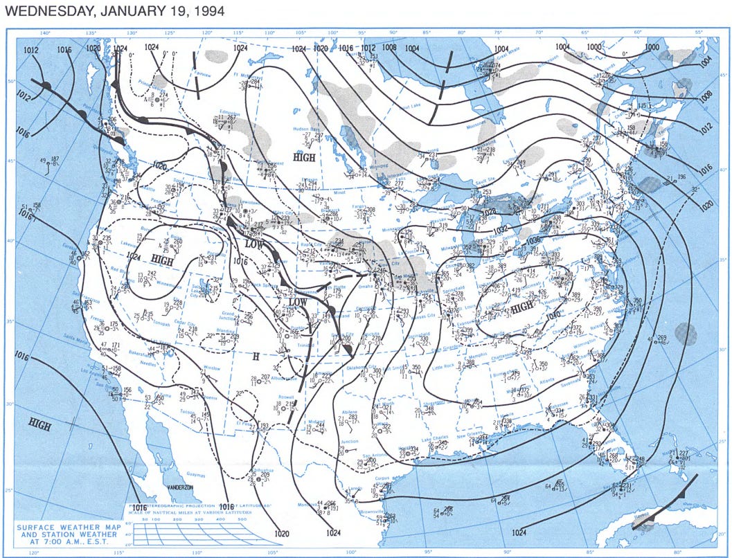
The high on January 19 only made it to -1°, which meant the average temperature for the day was an astounding 40.5° below average.
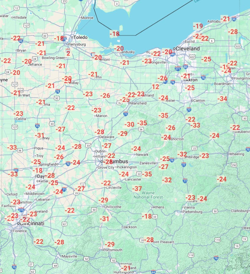
The coldest temperature in the state from that event was -37° in Logan, down in the Hocking Hills area.
The Columbus Dispatch has photos from that cold wave, and of course there are recordings of The Weather Channel.
🌭 For the weather weenies
-
Rare snowfall dusts Florida Panhandle (The Weather Channel)
-
The long-term health impacts from the LA wildfires are just becoming clear (NPR)