Before we get to the all-important snow…
Has it been stupidly windy lately?
Yes. Yes, it has.

Wind gusts have peaked at 30+ mph nine of the past 12 days. The average daily wind speed has also been above the long-term average 10 of the days.
This newsletter might be on hiatus for the next two issues (Sunday and next Wednesday). I’m tentatively going to the American Meteorological Society Annual Meeting in Houston, as long as weather doesn’t screw up those plans.
The 614cast
Thursday’s tl;dr
🌤️ Turning partly to mostly sunny, breezy at times with a high in the mid-30s.

Forecast highlights
☃️ Weekend snow
First things first: There’s still quite a bit of uncertainty about the big ol’ winter storm that’ll be tracking across the country later this week into the weekend.
Look at the territory covered by winter storm watches.
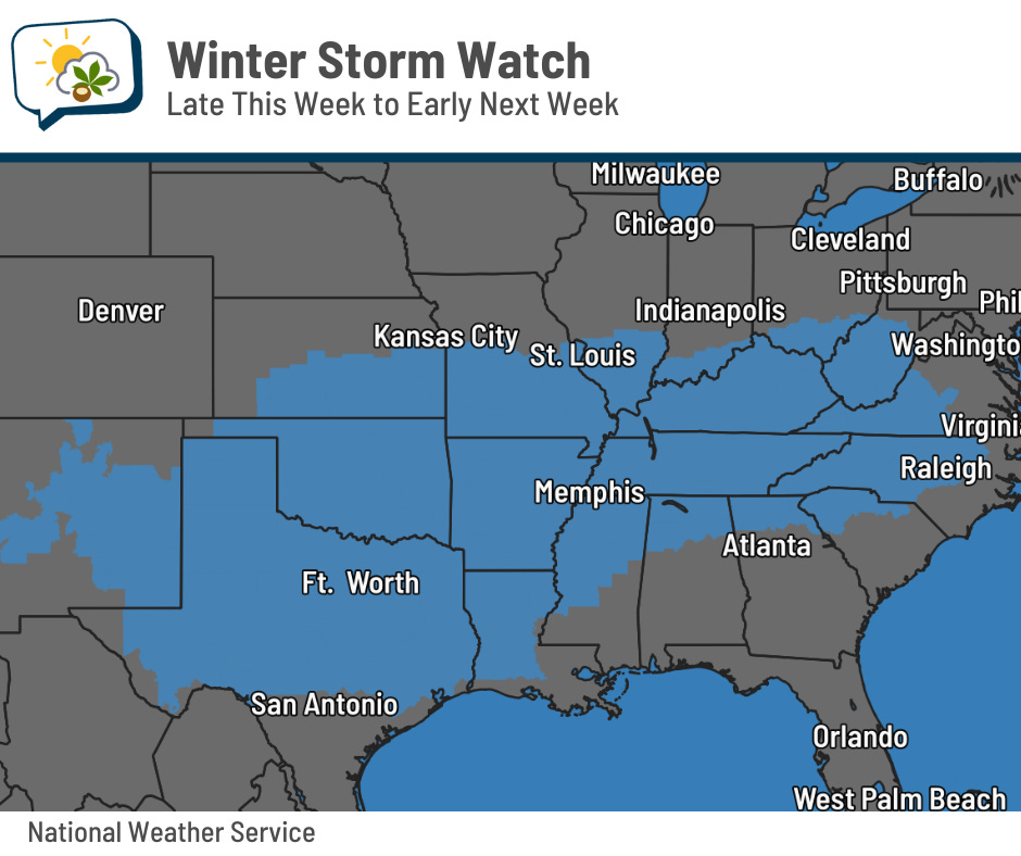
Those watches cover about 736,000 square miles, about the size of 16 Ohios! They also include a population of about 74 million people.
Locally, it appears the heaviest snow in Ohio will be in the southern part of the state, rather than in our area. Even so, I expect we’ll have enough to shovel. This will be a fluffy snow, given the cold temperatures.
Timing: I expect snow to begin later Saturday, probably after mid-afternoon. Arctic high pressure will keep the low-levels of the atmosphere dry until approaching moisture can finally overcome that, and it’ll take most of the day for that to happen. The snow should be heaviest Saturday night into early Sunday, then taper off in the afternoon.
Amounts: Anybody who’s giving specific numbers with a lot of confidence is… well, either they’re exceptionally talented or they haven’t been humbled by challenging forecasts enough times. I suspect it’s more the latter.
I don’t want to just regurgitate model data, but it does help illustrate what we’re dealing with. I’m sharing the forecast snow depth rather than snow accumulation:
-
GFS (primary American model): 1.5”
-
GFS Ensemble average: 4.4”
-
European: 8.0”
-
European Ensemble average: 6.7”
-
National Blend of Models average (snow accumulation; snow depth not available): 8.7”
The National Blend of Models’ middle 50% of forecast outcomes runs from 4” to 13”. That’s a big range for leaving out the lowest 25% and highest 25%.
Here’s another way of looking at the NBM data.
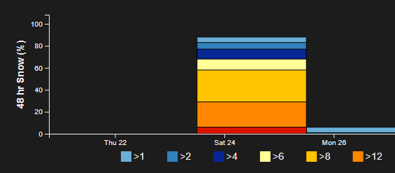
Its Wednesday afternoon run has an 88% chance of at least an inch of snow, and a healthy amount of 6” isn’t far behind at a 77% chance. Even a foot is clocking in at 29%. IMO, I’m skeptical of that outcome, but it’s worth noting as a possibility, even though I have a tough time believing it.
Meanwhile, the plot below tries to illustrate the “confidence” in the forecast of the AI flavor of the European Ensemble. Basically, it’s saying “what’s the spread in the forecast, relative to the amount?” For example, a 2” spread when it’s only predicting 2” is significant; a 2” spread when it’s forecasting a foot is not worth fretting over.
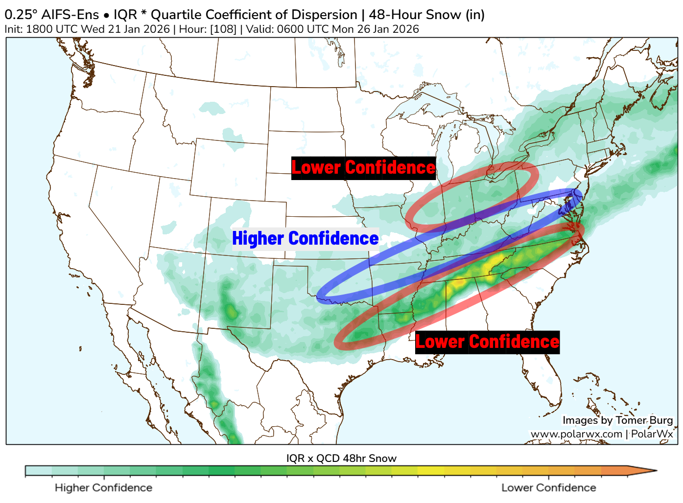
You can see that Ohio is in an area where that model has somewhat lower, or moderate, confidence.
As we get closer, the range of outcomes should tighten, partly because that’s the tendency in a chaotic realm like the atmosphere, and also because we’ll have more data. In fact, a Hurricane Hunter aircraft is out gathering data this evening.
What I suggest: Stay updated with forecasts from sources that are trustworthy. Plan for a shovel-able snow, with snow picking up Saturday evening and conditions being unpleasant through lunchtime Sunday. But remember that even as weather conditions improve Sunday afternoon, road conditions will lag behind, so have patience. Fortunately, temperatures will be warm enough Sunday for road treatments to be reasonably effective, and we will not have strong winds causing blowing/drifting issues.
🧣 Persistent cold
Oh yeah, it’s going to be cold, too.
Highs from Friday through next week will likely only be in the 10s and 20s. If we can manage any 30s, it’ll be just barely. We’ll also have numerous mornings in the single digits.
Wind chills should bottom out in subzero territory late Friday into Saturday morning, perhaps Monday, probably Tuesday…
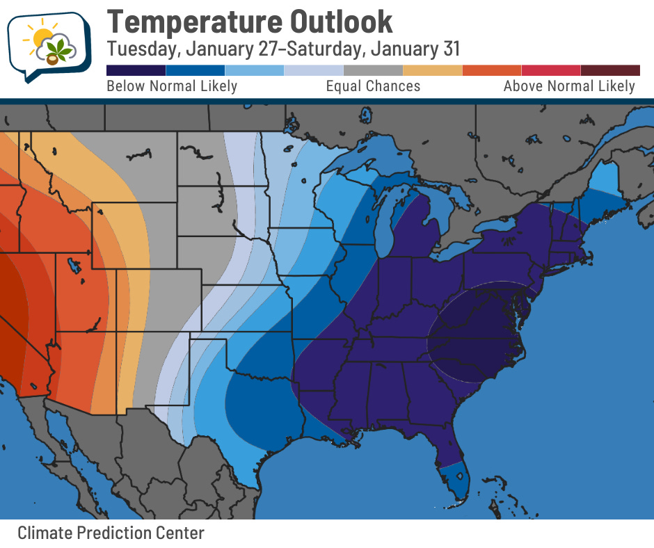
The Climate Prediction Center has pretty high chances of having below-average temperatures throughout next week.
📊 Thursday’s almanac
Normal low/high: 21 / 37
Record low/high: -16 (1936) / 71 (1906)
Sunrise/set: 7:48 a.m. / 5:39 p.m.
☀️ Gaining daylight!
I’m ending on a short but celebratory note.
The winter solstice was December 21, one month ago. Since then, we have gained 31 minutes of daylight. Pretty much all of that has been at the end of the day. (The “shortest” day of the year doesn’t have the latest sunrise and earliest sunset; those dates are offset.)
By the end of the month, we’ll be gaining more than two minutes of light every day.
🌭 For the weather weenies
-
Freezing rain accumulation model maps are misleading (Chris Vagasky/Bluesky)
-
Here’s how to best prepare for winter driving — and what to keep in your car (NPR)