The format of this newsletter will be different since it’s off-cycle and I’m slowing down after a 3 a.m. alarm this morning (I helped out 10TV WBNS on their morning show before coming home to do my day job).
If you’ve been following updates from local sources like the TV stations or National Weather Service, it seems to me that you have very good information, given what we know. I’ve seen a lot of consistency across sources, so I think we’re all pretty much aligned in our expectations.
The disturbances that will join up to make the winter storm are still a ways apart from each other; in fact, the southern chunk is still off the coast of Baja California. The northern chunk is still diving down western Canada.

❄️ First off, the snow.
How much?
I think 8–12” is a reasonable estimate at this point. That could shift, but I feel pretty good about ending up in that range.
When will it start and end?
Some light snow is possible late Saturday afternoon or evening, but this winter storm will be battling a lot of dry air in the lower levels of the atmosphere thanks to the arctic high that’s in place. It’ll take some time for the incoming moisture to overcome that.
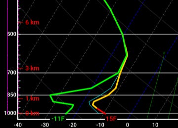
This is a forecast sounding for 4 p.m. Saturday, showing what a weather balloon would indicate if it were launched at that time and the model was right. Left is lower temperatures, right is higher temperatures, and there’s a big gap between the dew point (green) and temperature (red/yellow). Yes, things are saturated aloft, but there’s gobs of dry air below it.
Snow should really get going after midnight Saturday night and will continue apace throughout Sunday, winding down in the evening and largely ending early Sunday night. Some flurries are possible Monday.
When will the heaviest snow fall?
During the day Sunday.
Will it be fluffy snow or wet snow?
Kind of in between, leaning fluffy. Even though temperatures on Sunday will go from the teens to lower 20s, temperatures aloft will be a little warmer. Not enough to cause a changeover to sleet, but enough it’ll “wet” the snow a bit compared to what you might expect for surface temperatures.
The line graph below is the National Blend of Models’ expectation for snow-liquid ratio (ignore the bar graph). You can see that it dips down, indicating a shift from fluffy flakes to somewhat wetter snow (higher ratios are fluffy snow, lower ratios are wetter snow). But I don’t think we’ll get into snowball-snow consistency.
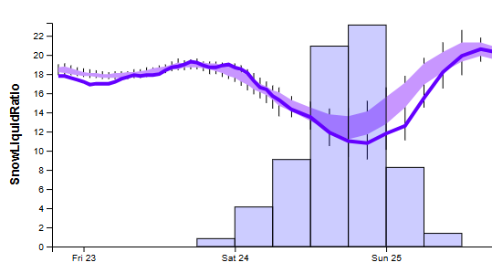
Wet snow is usually around an 8-to-1 ratio, “average” is 12-to-1, and fluffy is more like 18-to-1.
What could change?
Hopefully, not much. 😅 But I’ve done enough winter storms to know that they can have tricks up their sleeve. Even though we have a lot of data, we’ll know even more once the disturbance that’s offshore moves over land and we can sample it a bit better.
Anyway, two things come to mind: 1) Temperatures aloft will dictate the snow ratios, which has implications on amounts. If it’s a little colder aloft, amounts would be on the higher end; warmer aloft could cut into amounts a bit. 2) Narrow banding of heavy snow would produce locally higher amounts, and those fine-scale details are very difficult to predict more than several hours in advance.
I’m always nervous about high-end events because it’s really hard to get the really big amounts to materialize. But frankly, if we get 7” vs. 11”, does it really matter? Yeah, that’s a four-inch difference, but when talking actual impacts… it’s gonna be a mess, regardless.
How should I measure snow?
This guide and this guide should help you out.
🥶 Now let’s talk about the cold.
When will this snow melt?

lolz. Guidance doesn’t show much promise for that until maybe later in the first week of February. Suffice it to say, it’s not going anywhere anytime soon.
So when should I shovel?
If you can help it, don’t let it go past Monday. If the snow keeps getting driven and walked over, it’s going to just compress into ice and you’re going to have a heck of a time getting rid of it.
I plan to clear our driveway and sidewalk Sunday afternoon, then do another post-storm pass on Monday. I’d rather not do it all at once.
What will wind chills be like?
Single digits below zero until early Saturday afternoon, then single digits above zero through Sunday night. Single digits below zero all day Monday. -15 to -20 first thing Tuesday morning, not getting to zero until evening. Single digits below zero each morning the rest of the week.
Ugh I hate the cold.
Samesies, although check out the minimum wind chills from back where I used to live.
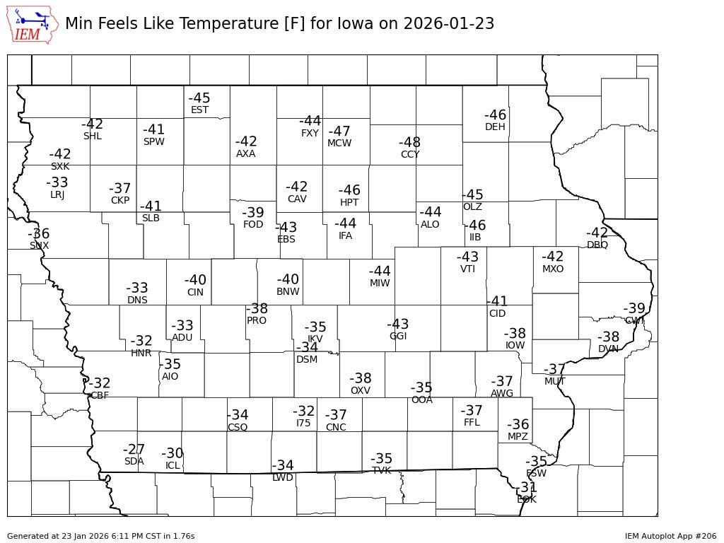
-40s wind chills in Iowa Friday morning. No idea how I lived there.
If you have to be out in the cold, you’re better off doing several thin layers under your coat rather than one or two thick ones. The air that gets trapped between each layer is a relatively warm insulator. Well, as much as it can be.
When wind chills get down to about -20, frostbite can occur in 30 minutes.