The 614cast
Today’s tl;dr
🌤️ Passing high clouds but still bright, high in the mid-80s.

Forecast highlights
🏜️ Have you ever seen the rain?
The only things happening with our weather are “warm” and “dry,” and since I covered the warmth yesterday, let’s talk about the dryness today.
One reason we’ve been dry the past few days, and will continue to be, is a blocked-up weather pattern. (After typing out a joke involving prune juice, I chose to remove it. You’re welcome.)
Here’s the pattern of the jet stream, which is the river of wind roughly 30,000 feet up:
There’s an upper-level high pressure over the western Great Lakes, and it’s “amplified,” meaning it goes way north-south. That’s something that doesn’t tend to move very quickly. Sometimes these manifest as an “omega block,” named because they resemble the Greek capital letter omega.
Complicating matters is a non-tropical low pressure system near the Mid-Atlantic that’s just going to drift around for a couple more days before finally weakening and kicking northeast. (This disturbance is sending over the high, thin clouds we’ll see today.)
And while dew points at the surface have come up, the mid-levels are still very dry. Not that there’s anything to kick off any rain, but that’s not helping.
So… when might we see rain? I wouldn’t hope for anything until early next week. Here’s the National Weather Service’s rainfall probabilities:
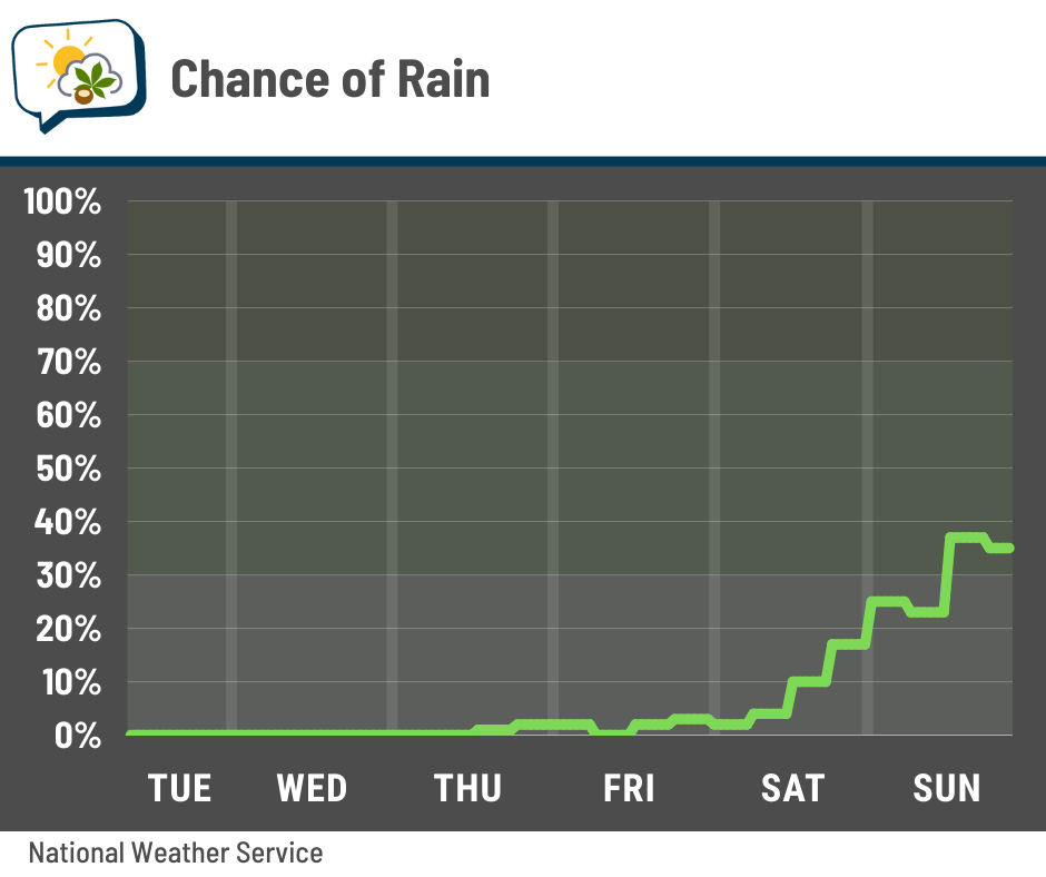
Not much to write home about until Sunday… and even then, it’s a far cry from a guarantee. And for the forecast models that do put down some rain early next week, it sure ain’t much. This is the National Blend of Models, through next Tuesday evening:
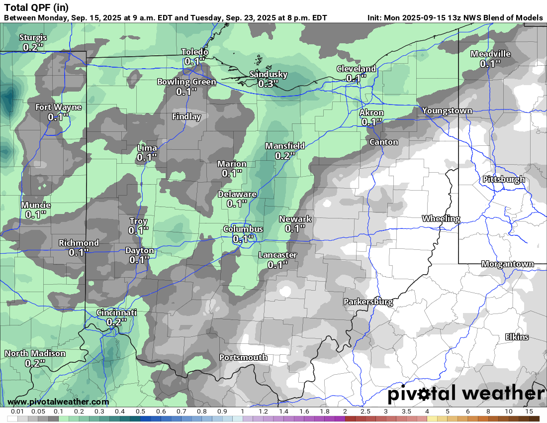
I want to emphasize that this isn’t gospel, especially since the particulars of rainfall are hard to pin down more than a few days in advance. But broadly, I don’t currently see signs that offer a reasonable promise of decent rain over the next week.
📊 Today’s almanac
Normal low/high: 57 / 78
Record low/high: 40 (1916) / 96 (1939)
Sunrise/set: 7:14 a.m. / 7:38 p.m.
🌧️ Summer rainfall
Not surprisingly, people are talking about how dry it’s been. There was a little conversation about it on the Columbus Weather Discord; one user felt this summer was just as dry as last summer, while another pointed out that this summer wasn’t really that dry until more recently.
Of course, I happened to know the latter is indeed correct. So I dug into it a little further.
Here are the key stats off the top:
-
June’s rainfall was almost 2″ above average (6.19″ vs. 4.33″)
-
July was just 0.01″ off the 30-year average of 4.67”
-
It wasn’t until August that we dried out (0.61″, normal is 3.74″)
-
This summer’s rainfall was 11.46″, close to the middle for the distribution of summer rainfall
-
Last summer had 5.07″, less than half of this summer and the third-driest on record
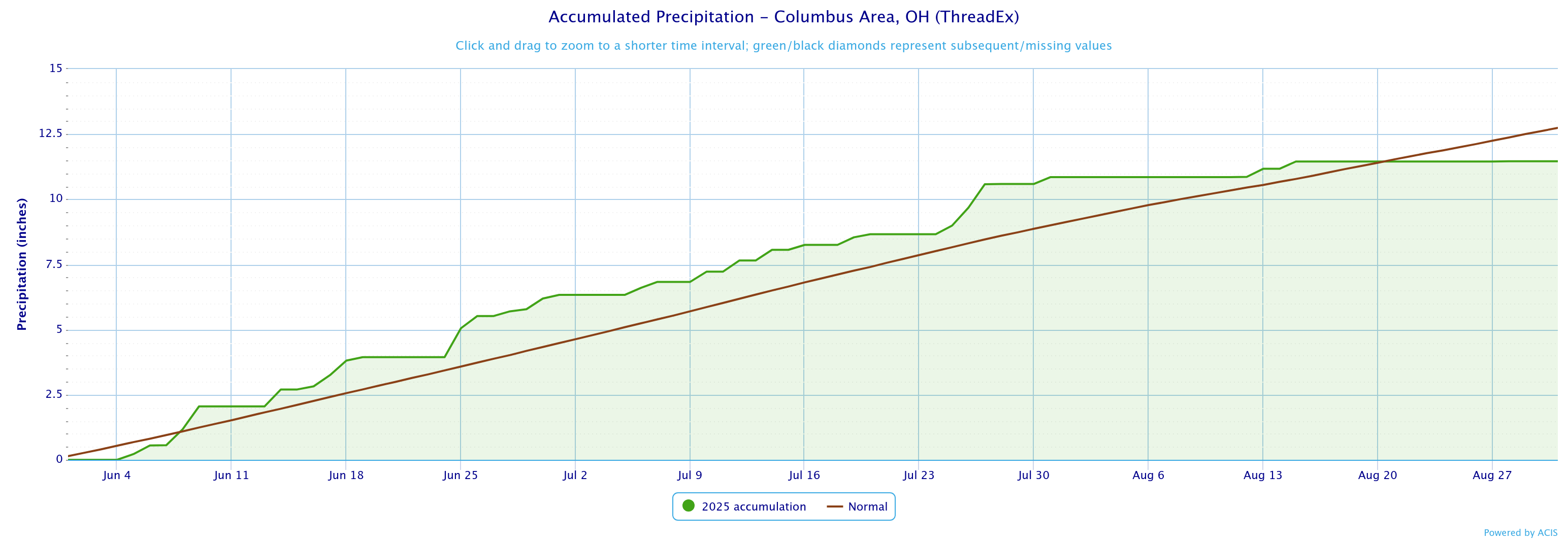
Here’s an accumulation graph of this summer’s rain (June 1–August 31) compared to average:
And here’s summer 2024:
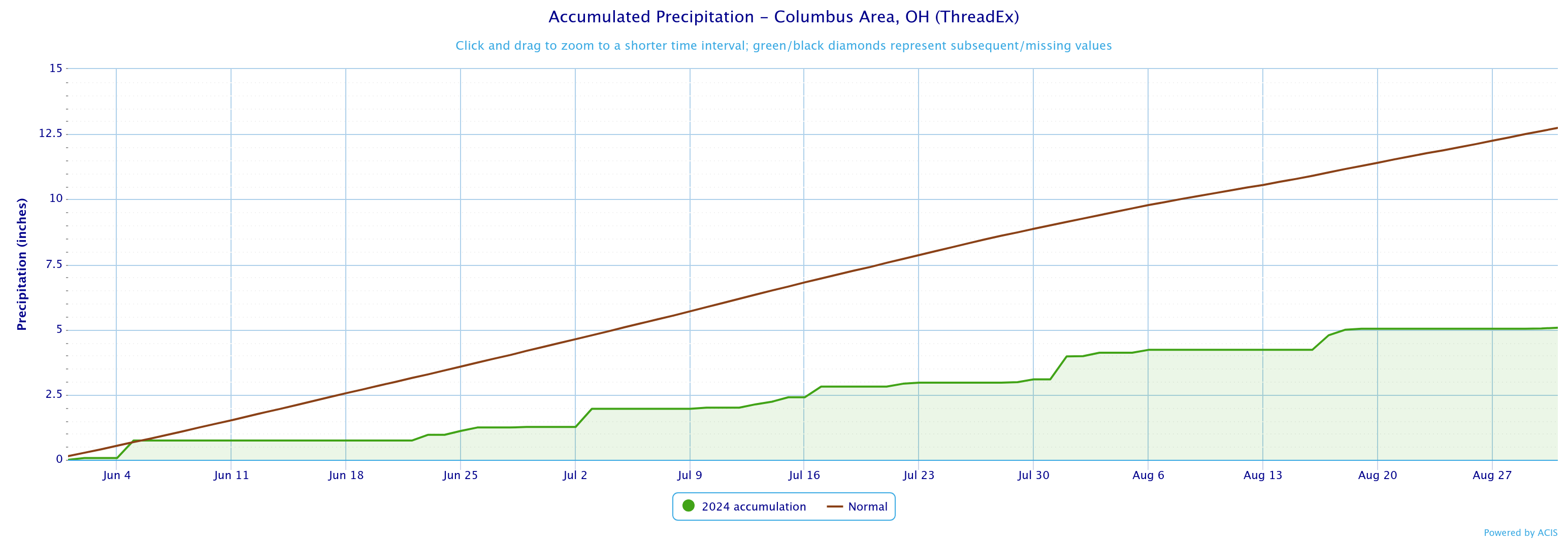
There’s a clear difference between the two. This past summer, we were in a surplus for most of the season and any lengthy stretch of dry weather didn’t happen until August. But last summer, we had numerous runs of little to no rain. We fell behind right away and never came close to making up for that lost ground.
That’s not to diminish just how dry it’s been recently. From August 1–September 15, we’ve officially had just 0.87” of rain, the driest on record for that period.
🌭 For the weather weenies
-
Sea surface temperatures and the quiet 2025 September tropics (Writers on the Storm)
-
Unusual tornadoes and flash flooding in North Dakota (Balanced Weather)