Columbus officially got past 20° on Sunday, which means our streak of highs below 20° ended at eight days. That ties the longest streak on record, which occurred in both 1893 and 1899.
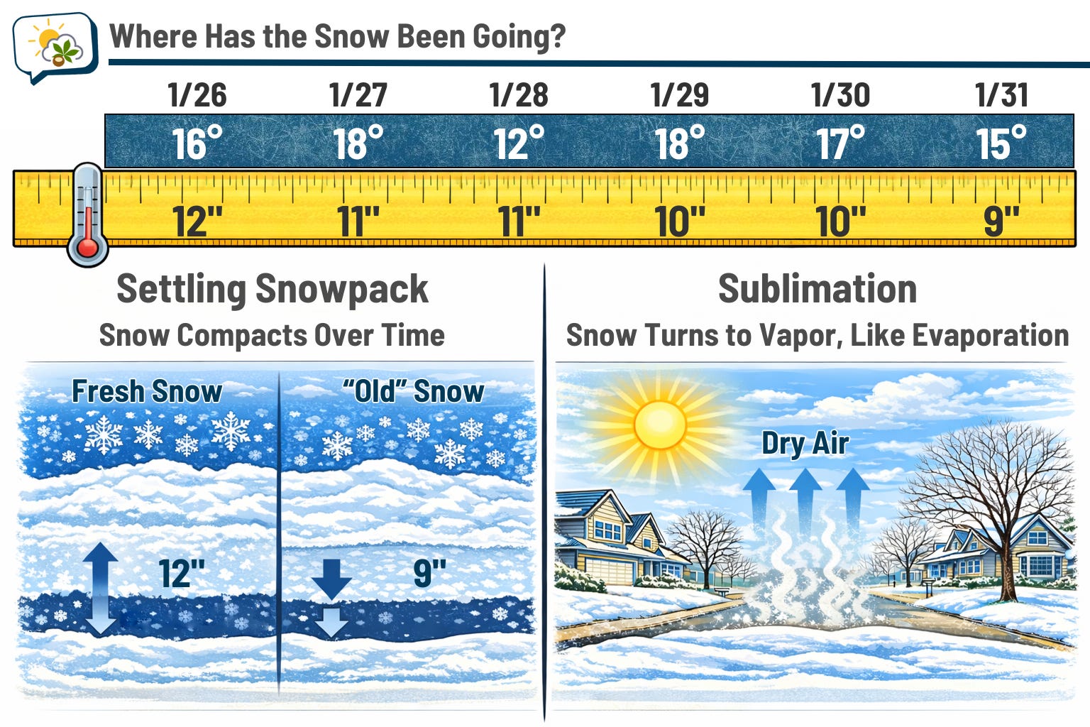
But even with the continuously cold temperatures, the snow depth has been decreasing. There are two reasons for that: the snow settles over time, and it’s also sublimating (which is like evaporation, but instead of liquid to gas, it’s solid to gas).
The 614cast
Monday’s tl;dr
🌨️ Mostly cloudy with flurries possible, high in the upper 20s.

Forecast highlights
🧊 Still waiting to thaw out
I wish I’d been wrong about this particular prognostication, but at least we’ve finally made it to the other side.
Unfortunately, “the other side” isn’t plastered with highs in the 40s and 50s. But as my grandma used to say, beggars can’t be choosers. We’ll make a run at the upper 20s on Monday, the warmest it’s been in about a week-and-a-half. Morning wind chills will probably be a smidge below zero, but they’ll quickly recover.
And while the week ahead is (mostly) warmer than we were over the past week, highs will still fall well short of average.
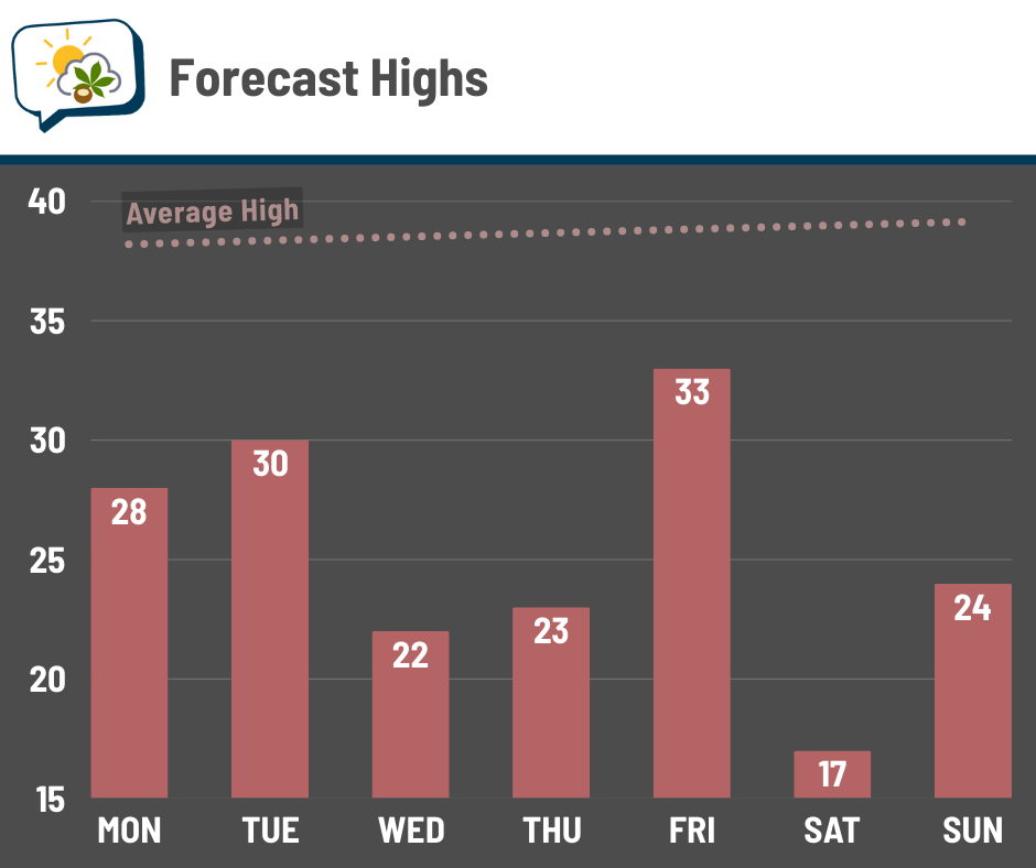
You’ll notice some ups-and-downs. We have a couple of Alberta clipper systems swinging through the region, and in the wake of each one, colder air dives in. It appears we’ll be brushed by some arctic air again next weekend, but it ought to be short-lived.
❄️ Clippers bring snow chances
I wouldn’t be surprised if Monday’s clouds squeezed out some flurries or even a bona fide snow shower, but a somewhat more organized disturbance comes through on Tuesday. Light snow favors southern Ohio with this one, although we could see some minor accumulation here.
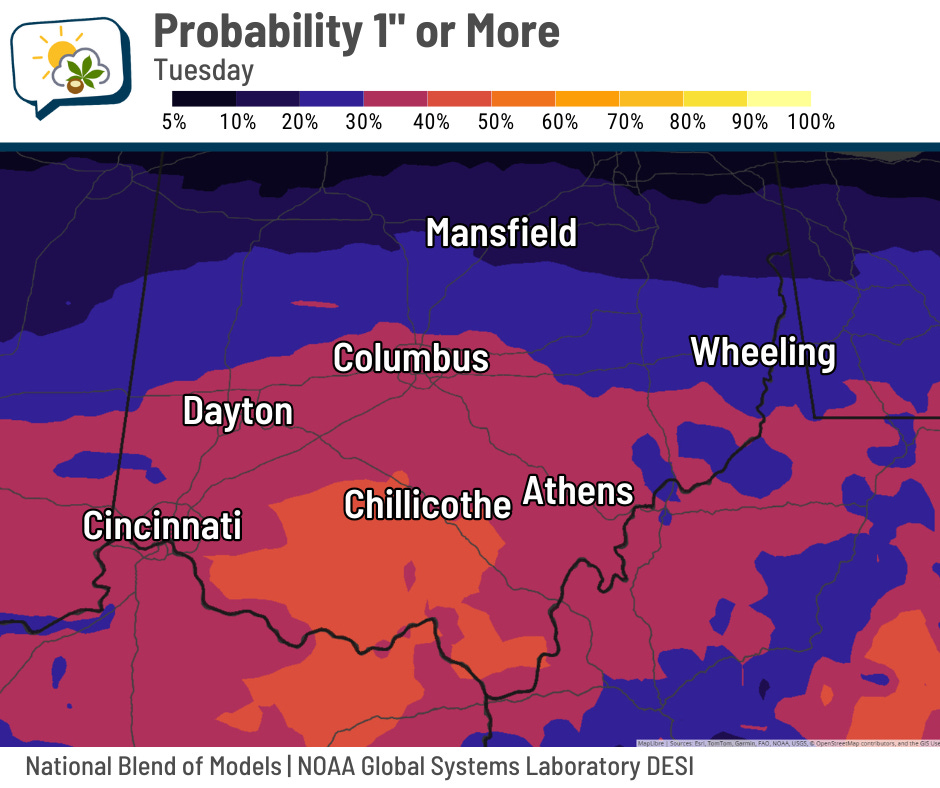
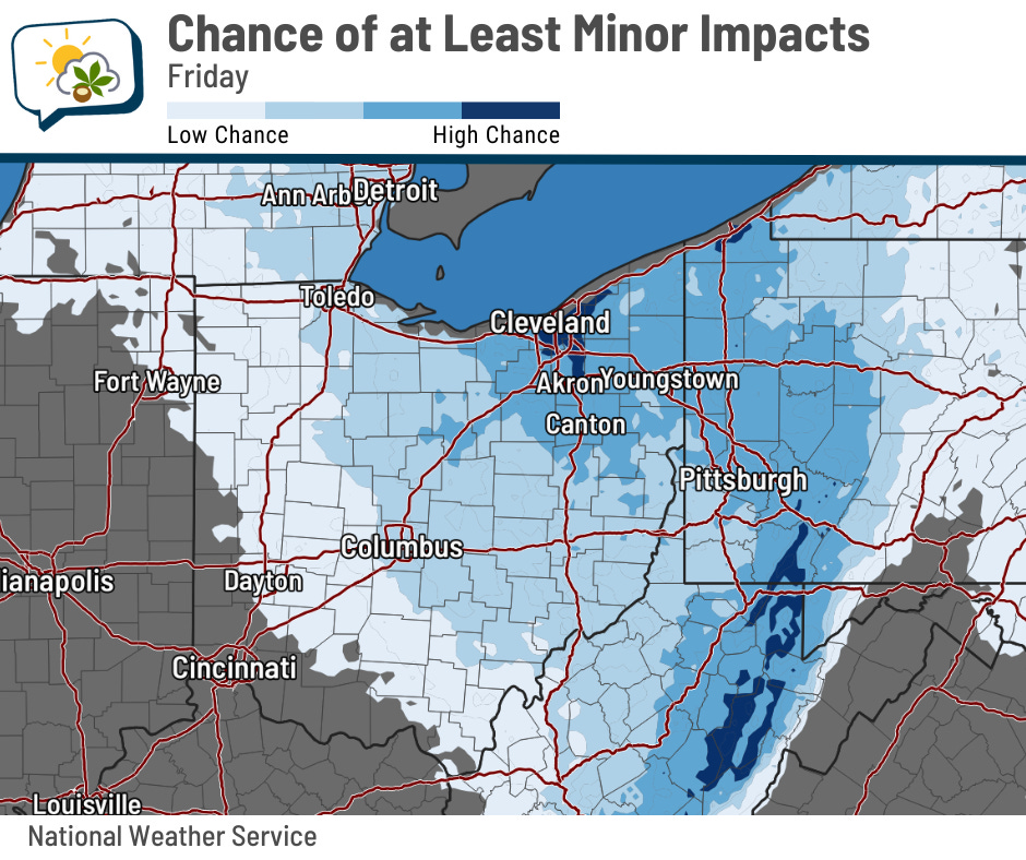
Another one comes through late Thursday night into Friday; that one takes a more northerly route. The Probabilistic Winter Storm Severity Index shows that northeastern Ohio currently has better odds of having at least minor impacts, but because it’s a ways out, keep tabs on it. At this point, I think it has a better chance of bringing some accumulation than the Tuesday system (but at least I’m not seeing signs of something significant).
📊 Monday’s almanac
Normal low/high: 22 / 38
Record low/high: -13 (1951) / 64 (1903)
Sunrise/set: 7:39 a.m. / 5:52 p.m.
🌕 Full Snow Moon and Groundhog Day
February’s full moon is the “Snow Moon,” and it was fullest at 5:09 p.m. Sunday evening. As is always the case, it’ll appear pretty full for another day or so… but with clouds thickening up soon, Sunday night’s pretty much our only night. If you do get a chance to see it, look for Jupiter above the moon.
A couple of the Native American names for the February full moon are “Midwinter Moon” and “When the Bear Cubs are Born Moon.”
Speaking of furry animals, our phine phriend Phil from Punxsutawney emerges from his burrow Monday morning.

The tradition’s roots go way back. An English folk song said that the weather on Candlemas (February 2) was a sign of winter either continuing or ending, and Germans later added a hedgehog into the lore. However, the groundhog took the place of the hedgehog when the tradition came to the United States (since, you know, we don’t really have hedgehogs here).
Of course, meteorologists have a history of being annoyed by Groundhog Day. Phil’s predictions aren’t accurate, and why do people hang on a rodent’s word but ignore our fancy science and knowledge? The thing is… I suspect almost everybody doesn’t actually believe that Phil’s a great forecaster. It’s just a fun tradition that is pretty harmless, and if some goofy tradition brings a little bit of joy or whatever, then maybe we should stop yucking on people’s yums.
In case you’re wondering, spring begins on March 20.
🌭 For the weather weenies
-
Storm Prediction Center interactive climatology data viewer (SPC)
-
2025 in Rewind: A year of NSSL innovation in severe storm science (National Severe Storms Laboratory/YouTube)