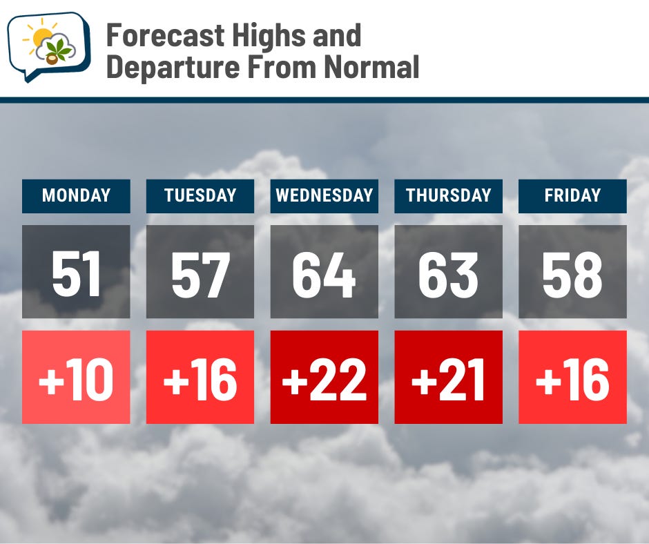
It’s as though a flip got switched. We’re in the beginning of what will be at least a nine-day stretch with highs of 40 or warmer — the longest such streak since November.
The 614cast
Monday’s tl;dr
⛅ Fog and clouds early, then some clearing in the afternoon. High around 50.
Forecast highlights
😶🌫️ Foggy Monday morning
The snowmelt plus Sunday morning’s rain have put a bunch of moisture in the air, and that should lead to areas of fog Sunday night into Monday morning. I would expect it to be pretty dense in places, too.
Here’s the visibility forecast from the National Blend of Models.
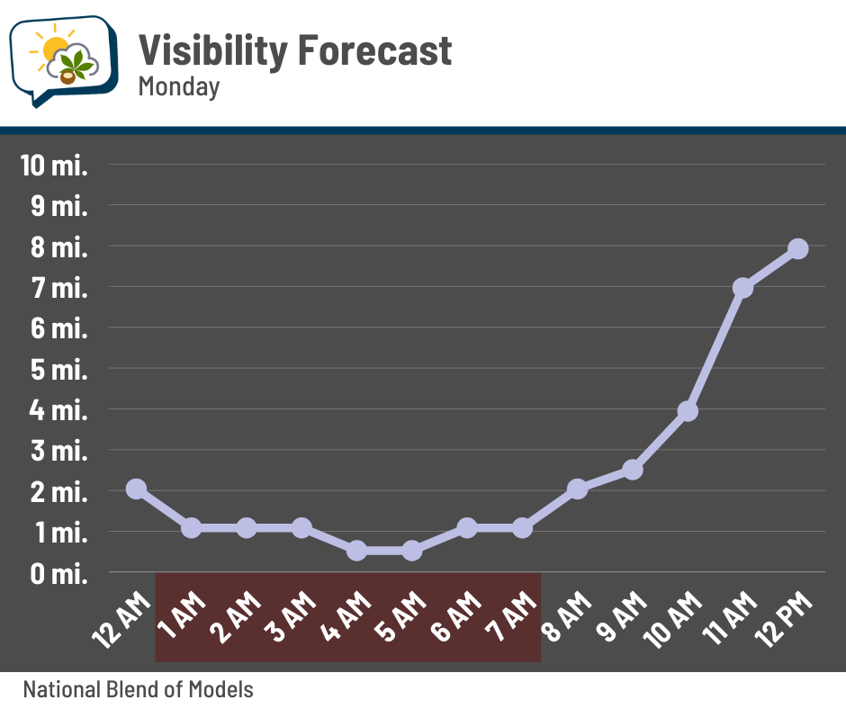
I noted in red the period in which it’s predicting visibility of a mile or less. Plan on a slower drive Monday morning. If you have an early flight out of CMH, be aware of the potential for delays.
Conditions should improve quite a bit after mid-morning.
🌡️ A stretch of mild weather
The pattern changed to allow more southwesterly air flow into the region last week, which has done a number on our snowpack. And now that the warmth won’t have to go into melting the snow and will instead work on warming the ground, we really start to see what that pattern change can do for our temperatures.
If clouds break up earlier than expected Monday, highs will probably be a few degrees warmer than my going forecast… but if they hold on, I’d expect them to stay in the 40s.
Regardless, every single day this workweek will be warmer than average. Wednesday’s record high is 66°, which could be in danger if things come together just right. It’ll be a breezy day, so we’ll see if there can be enough sun and warmth pushing in to get the job done. Thursday’s record of 70° ought to be safe, though.
Lows will be in the 40s Wednesday morning through Friday morning, which is considerably warmer than our highs were for an entirely-too-long stretch.
Colder air drops in this weekend through early next week, but it lasts only a few days before moderating yet again. Winter’s grip is forced to ease as we slide ever closer to spring.
☔ Intermittent rain chances later this week
Several disturbances bring us rain chances starting Tuesday night or Wednesday, lasting through the end of the week. We could even hear a rumble of thunder.
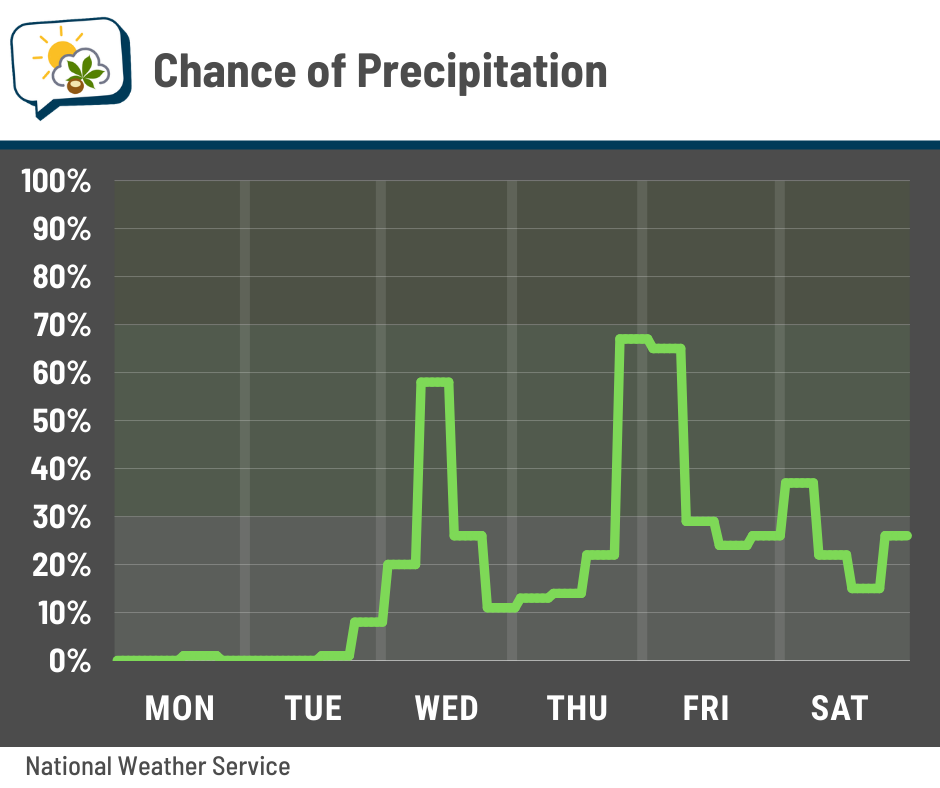
Timing the rain at this point is tricky, since it’ll accompany multiple waves of disturbances coming through. You can see that some of the current timing leans toward the nighttime hours. Even if things shift, the main thing to remember is that, even with several opportunities for rain, there will also be quite a few dry hours in there.
If temperatures get cool enough, there could be some snow in the mix on Saturday.
📊 Monday’s almanac
Normal low/high: 24 / 41
Record low/high: -4 (1904) / 72 (1883)
Sunrise/set: 7:23 a.m. / 6:09 p.m.
🧊 Still some cold to go
This week’s weather will definitely have us longing for spring. And while the upcoming temperatures are quite mild for mid-February, they’re hardly unheard of for this time of year.
But we also are still in winter, so even though spring is not far off, we still inevitably have cold temperatures ahead of us.
This graph shows the frequency of the last spring date with a temperature below 36° (frost), 32° (freeze), 28° (hard freeze), and 20° (just an arbitrary number).

I’ll help you navigate this. Let’s look at 20° or colder (red line): On February 1, every single year on record had its final 20° on that date or later. Following it forward to March 1, just over 80% of years still had their final 20° ahead. On March 15, half of the years on record had their final 20° reading behind them and half still were waiting for it.
Another way of thinking it is this: Climatologically, you have about an 80% chance of having at least one more low of 20° or colder after March 1, but only a 50/50 chance after March 15.
Let’s check 32° (orange). You can fully expect a freeze straight through about April 1, and you don’t even get to the 50/50 mark until April 19. If you feel better about planting only when there’s a 10% chance of a freeze (climatologically speaking), you have to wait until May 5.
🌭 For the weather weenies
-
What the National Center for Atmospheric Research means to the atmospheric sciences (Physics Today)
-
Trump admin is pulling supercomputers out of key weather and climate research center (CNN)