Our magnolia is starting to blossom. This is our fifth spring here, and this is the earliest it’s happened, beating 2024 by a couple of days. Typically, it’s been more like the third week of March. Our hardy perennials have really been pushing out of the ground pretty fast this week, too. I’ll have to clear away last season’s dead growth this weekend.

The 614cast
Thursday’s tl;dr
🌤️ Partly to mostly sunny and breezy, high in the mid-40s.

Forecast highlights
🎢 Big temperature swings
Thermometers are going to have some whiplash in the coming days. Look how much we bounce around…
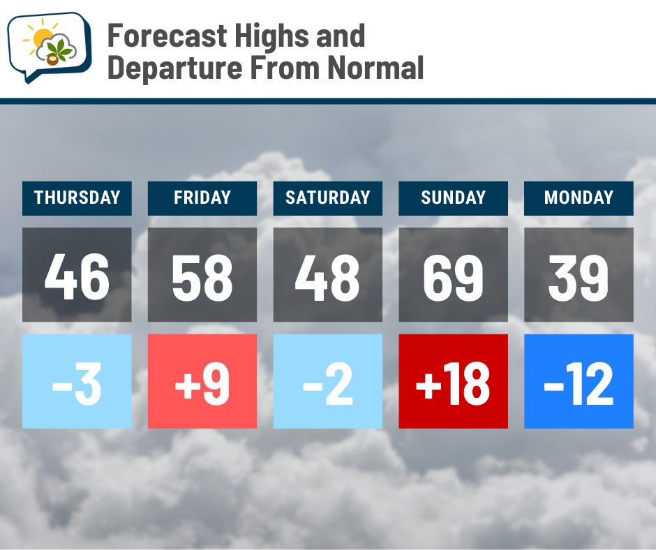
Thursday and Saturday will feel chilly, even though highs will actually be pretty darn close to average. That drop from Sunday into Monday, though… 😱
(BTW, if your weather app is showing a high in the 50s or something for Monday, it looks like we’ll have our high very early and the daytime hours will have temperatures in the 30s. If the front slows down quite a bit, then that’d change, but there’s very good agreement among the models on the timing.)
Guidance strongly indicates early next week is going to be relatively cold with temperatures stuck well below average Monday and Tuesday, with some recovery on Wednesday.
Unfortunately, morning lows will fall into the 20s, so we still have hard freezes ahead.
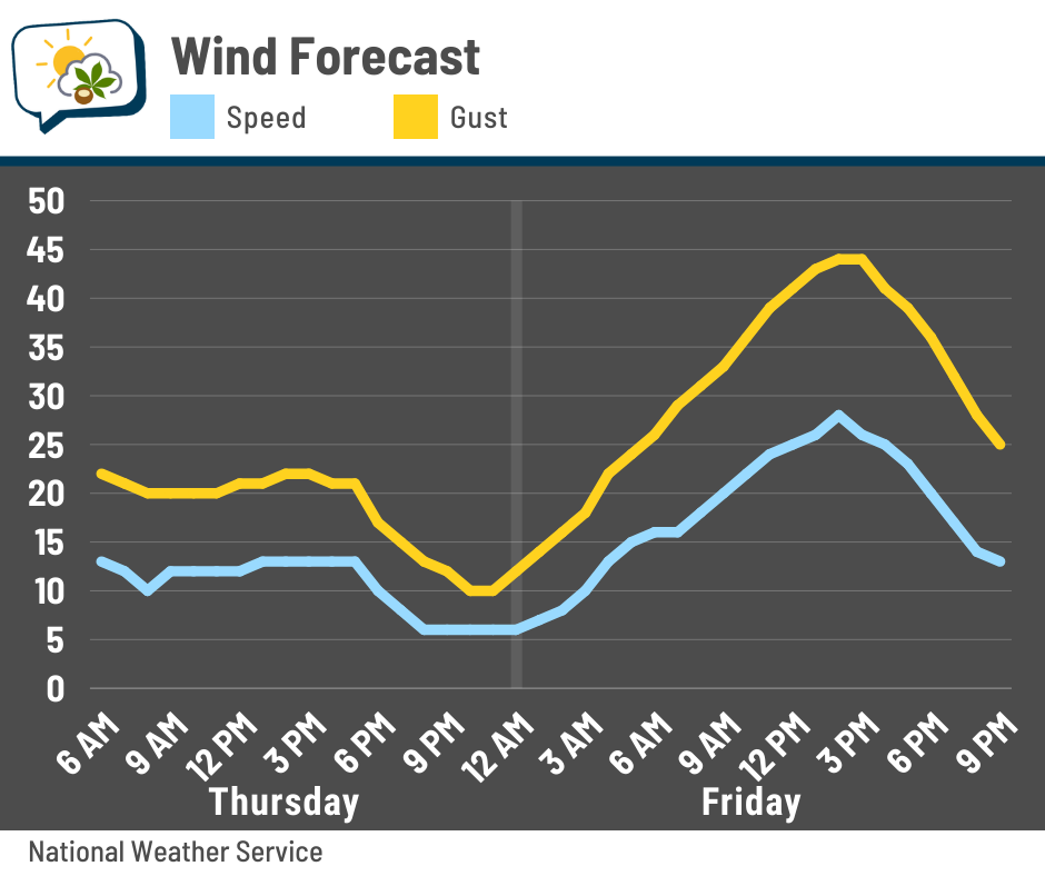
💨 Blustery end to the week
Thursday’s going to be a run-of-the-mill breezy day with gusts between 20–25 mph. Friday, though, ought to be much windier. Peak gusts should exceed 40 mph. If that’s your garbage day, keep that in mind…
✌️ Tracking two systems
A clipper system could brush us with light precipitation (perhaps a wintry mix?) early Friday. However, the the next notable system should come Monday morning, based on current data.
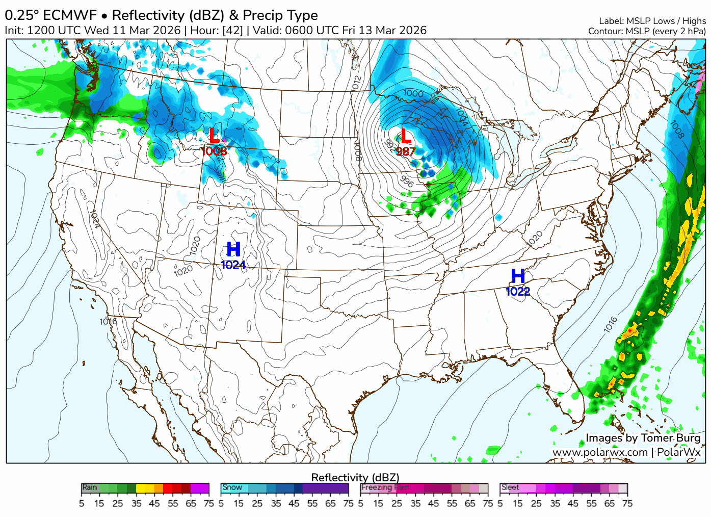
It’s a pretty sharp line of rain and perhaps thunderstorms along a cold front. It’s the same one that knocks temperatures down into the 30s.
📊 Thursday’s almanac
Normal low/high: 31 / 49
Record low/high: 1 (1948) / 75 (1990)
Sunrise/set: 7:48 a.m. / 7:35 p.m.
🌨️ Last snows of the season
Thinking spring? While snow becomes less and less common this time of year, we’re not necessarily out of the woods yet.
Using the 1991–2020 climate period, the average date of the last inch of snow is March 1. The average date of the last measurable snow (at least 0.1”) is March 27. Only about a quarter of the years on record have already had their final measurable snow by now, and the vast majority of years still have at least a handful of snowflakes in April, even if it’s not enough to measure.
The latest date with at least an inch of snow was April 25, 2005, when 3.0” occurred. The latest date with measurable snow was May 7, 1989. 0.8” fell that day.
Snowfall data for Columbus go back to 1947.