A quick note about Friday’s wind gusts and how they ranked…
The 614cast
Monday’s tl;dr
🌨️ Cloudy, windy, spotty snow showers. Daybreak temperatures in the 40s fall into the 30s.

Forecast highlights
⚡ Line of nighttime rain/storms
A powerful cold front is on track to blast through a few hours before daybreak Monday morning. It’ll bring a line of rain/storms along with it, probably around 3–4 a.m. in the Columbus area.
The severe risk is pretty low, but we could have locally enhanced gusts that cross the “severe” threshold of 58 mph. Energy for robust storms will be lacking to begin with, and dew points have been lower than model expectations. That’ll make it even harder to get much in the way of storminess.
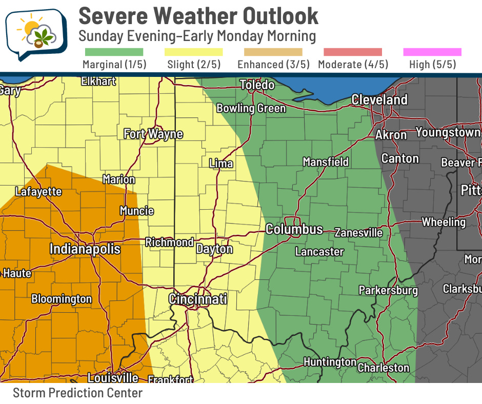
Here’s the Storm Prediction Center Outlook; you can see odds favor severe weather back to our west.
Rain/storms will be long gone by the morning commute.
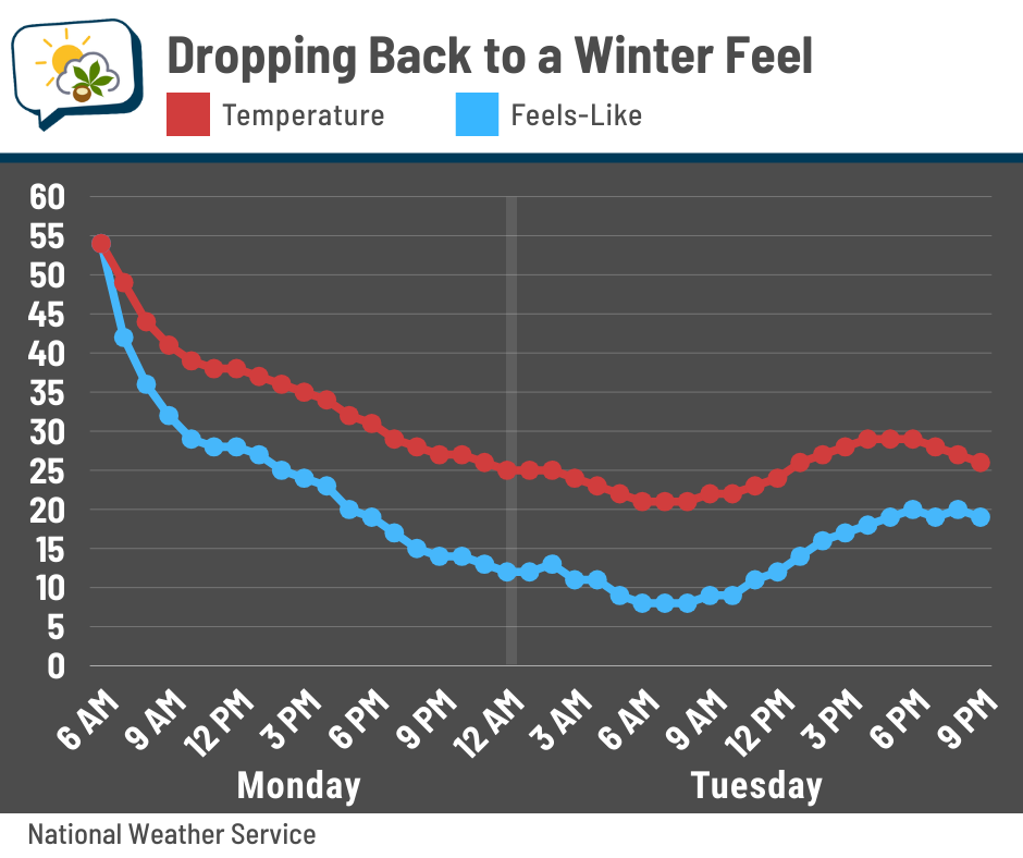
🌡️ Wintry to start the week
That cold front means business with temperatures. Early risers may catch the very fleeting 50s, but most of us will be heading out the door when temperatures have fallen to the 40s… and they’ll continue slipping from there, dropping into the 30s before lunchtime.
Wind chills will be in the 20s in the afternoon, then the 10s for the evening.
Spotty snow showers are possible Monday, mainly in the afternoon and evening. While these should be small if they do develop, they may briefly drop visibility, including during the PM commute. Accumulation is not likely, although a bit could stick to pavement if the snow showers persist after sunset.
Tuesday will be a cold one! Morning lows will be close to 20 along with wind chills edging into the single digits. We’ll have trouble getting out of the 20s for an actual high temperature.
Thankfully, this is a short-lived chill. Here’s how the full week looks.
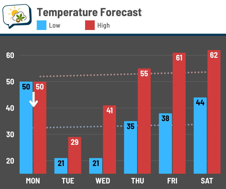
If you have perennials that tend to show up in March, you’ve probably noticed they’ve emerged. With a hard freeze Tuesday and Wednesday morning, sensitive plants will need to be protected. I imagine that most of the stuff that’s started showing up is pretty hardy, though.
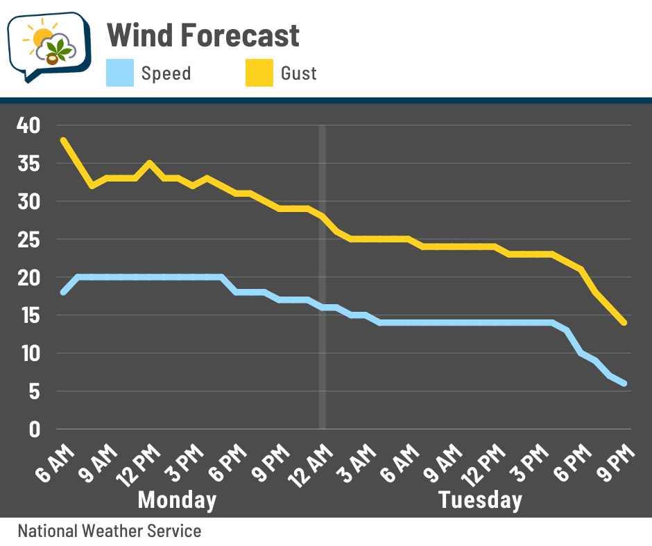
💨 Gusty breezes continue
While the winds aren’t nearly as strong as they were on Friday, thank goodness, they’re still up there overnight into Monday. They’ll gradually back off during the day Tuesday.
📊 Monday’s almanac
Normal low/high: 32 / 51
Record low/high: 4 (1900) / 79 (1945)
Sunrise/set: 7:41 a.m. / 7:39 p.m.
🌪️ Severe Weather Awareness Week
This is Severe Weather Awareness Week in Ohio. Each day has a theme:
-
Sunday: Overview & Preparedness
-
Monday: Watches, Warnings, and Outlooks
-
Tuesday: Receiving Alerts/WEA
-
Wednesday: Tornadoes & Sheltering (Statewide Tornado Drill at 9:50 a.m.)
-
Thursday: Thunderstorms & Lightning
-
Friday: Flooding
-
Saturday: Become Involved/Be in the Know
The Ohio Committee for Severe Weather Awareness has this page with links to resources and information. They also explain the various weather words that you might encounter during significant weather.
🌭 For the weather weenies
-
Hawaii storm shatters rainfall records dating to 1951. More rain is coming (San Francisco Chronicle)
-
Woman dies fleeing Nebraska wildfire; governor surveys damage across the state (KOLN/KGIN)
-
El Niño is set to take hold this summer, driving up global temperatures (NPR)